Category Archives: Places

Marshalls and Hinkles in PB

The Hinkle house, built in 1896 on a lemon ranch a half-block to the east and moved to 1576 Law Street in 1926

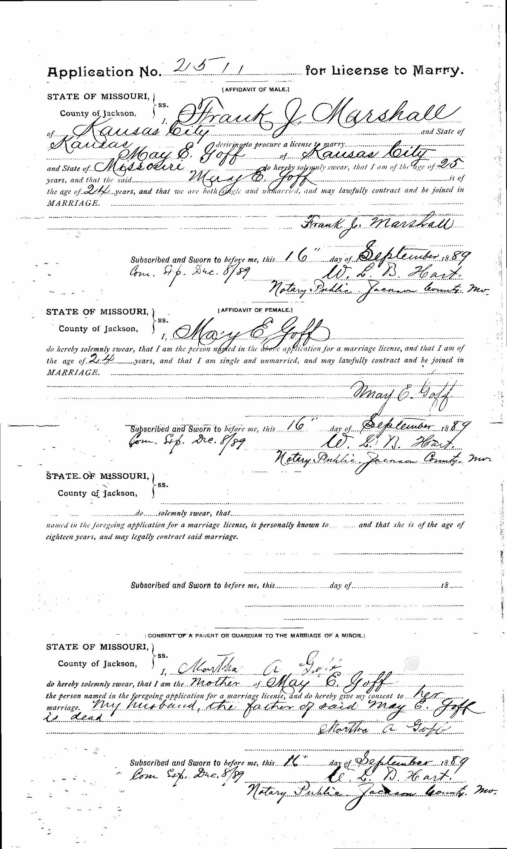
On September 16, 1889, two sisters appeared before a notary in Kansas City, Missouri, to sign applications for marriage licenses. Application No. 2511 was filled out for May E. Goff, who solemnly swore that she was of the age of 24 years, single and unmarried, and could lawfully contract and be joined in marriage to Frank J. Marshall, who was also 24, single and unmarried. Application No. 2512 was for Carrie Goff, who swore she was 22, single and unmarried, and could lawfully marry Victor A. Hinkle, who was 32 years of age. The brides were stenographers or ‘typewriters’, living in Kansas City with their widowed mother. The grooms were both salesmen for the Mosler Safe Company, where Frank’s older brother Thomas B. Marshall was manager.

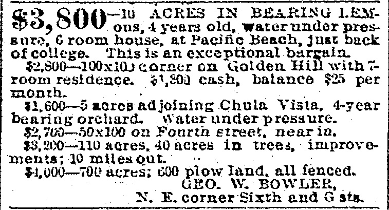
In March 1894 the San Diego Union reported that Frank J. Marshall of Kansas City had bought two ten-acre blocks in Pacific Beach and had them plowed, piped and planted to trees; 1400 lemon trees and also prune, orange, peach, pear and apricot trees. A hedge of Monterey cypress would also be set out all around his land. Mr. Marshall would be returning to Kansas City in April but would return to Pacific Beach early next fall. He would bring his brother with him and each would build a handsome residence. The Union explained that Mr. Marshall had come from Kansas City to Los Angeles and wrote to a San Diego resident for information regarding climate, land, etc. He was advised to come and see for himself and was fully satisfied with what he saw in Pacific Beach.

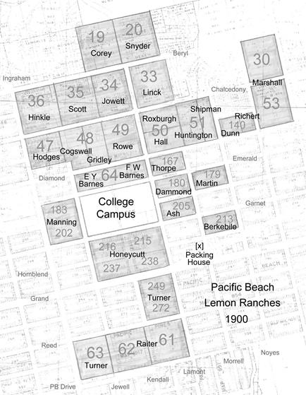
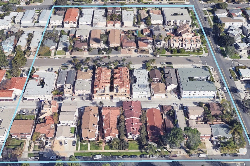
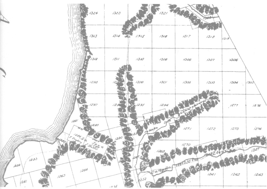
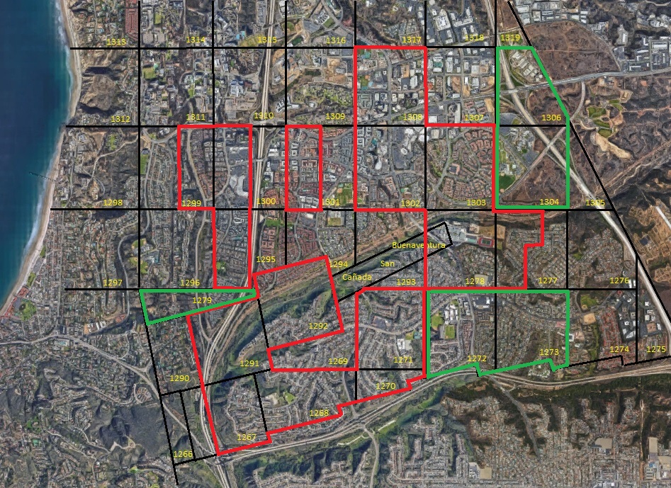
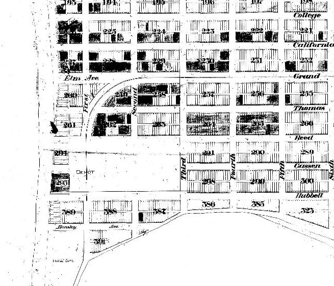
The ‘ten-acre blocks’ that Frank Marshall purchased in February 1894 were laid out in the amended Pacific Beach subdivision map of 1892, on which the area north of the College Campus (now Pacific Plaza) and Alabama Avenue (now Diamond Street) had been divided into ‘acre lots’ of about 10 acres each, intended for agriculture. Mr. Marshall had paid $2150, or $125 an acre, for acre lots 30 and 53 (which were actually 8.6 acres each). On the map these lots were between 14th (now Olney) and the northern projection of 15th (Pendleton) streets and were separated by Idaho Avenue (Chalcedony Street), with lot 30 extending north to Georgia Avenue (Beryl Street) and lot 53 south to Alabama (Diamond; although the area is now part of the Admiral Hartman Community, where this street no longer exists).

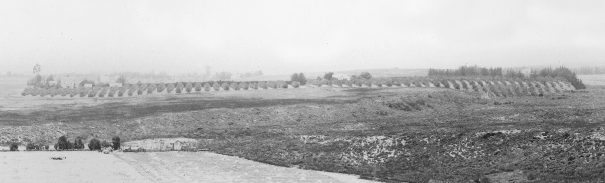
In 1895 the San Diego Directory contained only 37 listings in Pacific Beach, half of whom were described as farmers or ranchers, many of them growing lemons on ranches developed on the acre lots. Lemon ranching was the principal economic activity in Pacific Beach and the Union’s weekly column of news from Pacific Beach regularly reported on developments affecting the lemon business. In February 1895 the column announced that the Marshalls, who owned twenty acres of fine lemon ranch at this place, were preparing to come to California and build on their ranch and make their homes there. In May the news was that the Marshalls expected to have their arrangements completed for removal to this place shortly. Their 20-acre ranch was looking well. They arrived in Pacific Beach in June and the Union reported that they had rented the Wilson house until they could build on their lemon ranch; ‘They come fully equipped for business and pleasure, having brought with them no less than four vehicles, and an abundance of home-making necessities’.

The Marshall lemon ranch on acre lots 53 and 30 of Pacific Beach from the east (San Diego History Center Photo #283)

The Wilson house was the lemon ranch house on Acre Lot 33, a few blocks west of the Marshalls’ property, but the Marshalls didn’t occupy it for long. In September 1895 the Union reported that Mr. Marshall’s new house made a fine showing against the hills (and that Gen. Stearns, an ex-United States senator, had purchased the Wilson place). A few weeks later the paper reported that the Marshalls were moving into their new house and added that Mr. Marshall’s brother and brother-in-law were making arrangements to come to California and would locate at this place. The two families expected to reach Pacific Beach before winter.

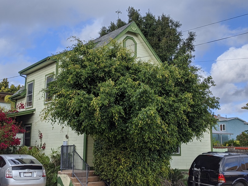
Mr. Marshall’s brother arrived in January 1896; according to the San Diego Union T. B. Marshall and family of Kansas City had arrived from the east and were at the Horton House hotel downtown. The February 1, 1896, Union announced that T. B. Marshall was building on his ten-acre tract. Construction must have been rapid because by February 24 the paper noted that several artistic cottages had been built at this place during the year but the architecture of T. B. Marshall’s new house was a decided change. In April the report was that T. B. Marshall had moved his family into his new residence and a month later that Mr. T. B. Marshall’s new home was ‘the finest in our colony’. Photos of house, located at the corner of Olney and Diamond streets, do indicate that the architecture was a decided change from the plain frame houses on other lemon ranches at the time, such as the one built in 1892 on acre lot 34 and still standing at 1860 Law Street. The T. B. Marshall home included Queen Anne-style design features like bay windows and a square tower topped with a decorative widow’s walk.

Thomas B. Marshall home on acre lot 53 (Pacific Beach Historical Society Photo)

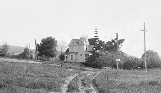
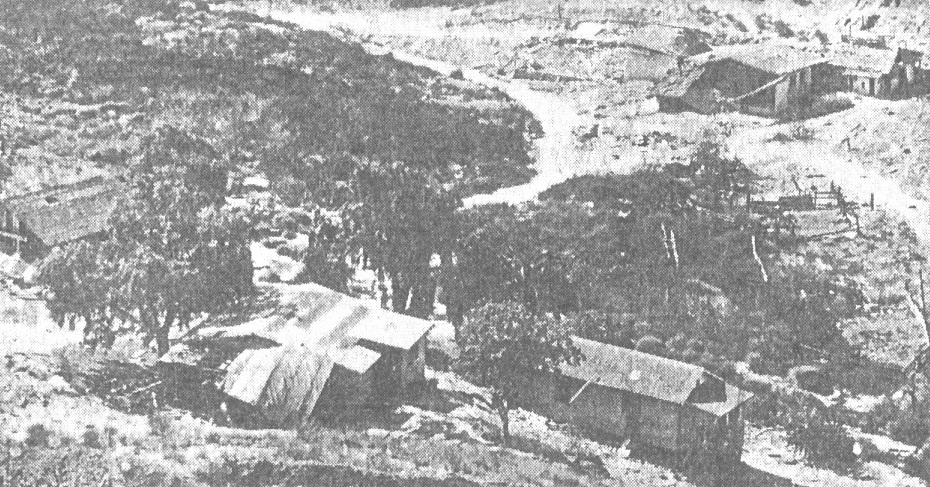
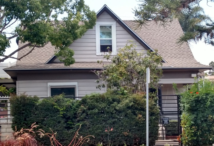
Frank Marshall’s brother-in-law, Victor Hinkle, with his wife Carrie, May Marshall’s sister, were the other family that had made arrangements to locate at ‘this place’ and expected to arrive before winter. In December 1895 the Union reported that Mr. and Mrs. Hinkle had moved into the Will Wagner cottage (on Diamond Street a half block west of where the T. B. Marshall house would be built). In February 1896 the Hinkles purchased acre lot 36, 10.2 acres lying between what today are Chalcedony, Ingraham, Beryl and Jewell streets, paying Alzora Haight $2000 or nearly $200 an acre for a developed lemon ranch. Acre lot 36 had originally been purchased by George Tutton in January 1892 but had been owned by Mr. and Mrs. Haight since September 1892. The Haights apparently never built a home on their property; a news item from 1894 reported that Mr. Haight and family had been ‘camping’ on their ten-acre ranch. In May 1896 the news was that Mr. Hinkle, who had bought the Tutton ten acres set to lemons, was building a fine residence there. Early photos show that the architecture of the Hinkles’ new residence was also in the Queen Anne style of the T. B. Marshall home, including a square tower with a decorative widow’s walk.

Frank and Thomas Marshall were joined in Pacific Beach by another brother later in 1896 when Clifford Marshall and his wife took up residence in Martha Dunn Corey’s cottage, also on Diamond Street in the block west of the new T. B. Marshall home. Like most Pacific Beach residents, the extended Marshall family and the Hinkles joined the Presbyterian Church and participated in church and community activities. When Miss Marian Thresher, the soprano in the church choir, departed for Jamul for a year in November 1896 Mrs. Clifford Marshall gave her a farewell party and her place in the choir was taken by Mrs. Hinkle (Miss Thresher was a former student at the San Diego College of Letters in Pacific Beach). Choir practice was held every Saturday afternoon at Mrs. Clifford Marshall’s residence.

Frank Marshall had purchased two Pacific Beach acre lots and had them plowed, piped and planted to trees while he returned to Kansas City, leaving the ranch in charge of Ed Barnes, another local lemon rancher (and another former College of Letters student). It was more than a year later that Frank and his brother Thomas moved from Kansas City with their families and built impressive homes on the ranch, and still much of their time was spent away from Pacific Beach, leaving day-to-day operations of the lemon ranch to others. In April 1897 the local news was that T. B. Marshall and family had returned to their beautiful home and young lemon grove after a prolonged stay in Los Angeles. They had also come down from Los Angeles to spend the holidays at their Manjessa ranch (presumably named for their two daughters, Maude, or Mandy, and Jessie). In July 1897 the news was that T. B. Marshall and family were to leave for Los Angeles for a year and in January 1898 Mr. Dorst and wife moved into T. B. Marshall’s elegantly furnished house. In April and again in July 1899 T. B. Marshall spent a few days in Pacific Beach looking after his interests before returning to Los Angeles, where he was listed in the 1900 census as general agent for Mosler Safe Co.

The lemon business depended on growing and harvesting lemons but also on curing, packing and shipping them to distant markets, mostly in the Midwest. In December 1896 Sterling Honeycutt, also a lemon rancher, made a deal with the Pacific Beach Company in which he acquired the north half of block 239, south of Hornblend between Lamont and Morrell streets, and also the company’s hotel and dance pavilion on the ocean front near the foot of Grand Avenue. The agreement required Honeycutt to move the hotel and pavilion from the beach to block 239, where the hotel ended up at the corner of Hornblend and Lamont and the pavilion at the corner of Hornblend and Morrell, adjacent to the tracks of the San Diego, Pacific Beach and La Jolla railway, which then ran along what is now Balboa Avenue. Honeycutt refurbished and reopened the hotel, but the dance pavilion was converted to a facility for curing and packing lemons and loading them onto railroad cars at the adjacent siding. In November 1897 Honeycutt sold the northeastern quarter of block 239, including the packing plant, to F. J. Marshall and F. W. Barnes, who each acquired an undivided half-interest in the property (F. W. Barnes was Ed Barnes’ father and was also a lemon rancher).

Although Frank Marshall owned a lemon ranch and a half-interest in the community lemon packing plant, he also remained connected to the safe company in Kansas City and at the end of 1897 he returned to resume his former position there (the 1899 Kansas City directory listed Frank and Thomas Marshall, both working for Mosler Safe Co. and living at the same address). Clifford Marshall moved from Dr. Corey’s house into Frank Marshall’s house in January 1898. The Union reported that Mrs. Marshall and daughter Verna would spend the winter in San Diego and would remain until spring, then would return to Pacific Beach to make their future home. In October 1898 Frank Marshall returned from Kansas City to ‘make quite a visit’ and in April 1899 he returned once again ‘with the intention of making his home in San Diego’ (the 1900 federal census listed Frank Marshall, rancher, living with wife May and daughter Birdie at 1460 3rd Street in San Diego). In the absence of the Marshall brothers Mr. Lewis Martin had been in charge of the ranches in 1899 and Mr. Jacobson took over their care in 1900.

In December 1900 Frank and May Marshall sold acre lot 30 as well as their undivided half-interest in the packing plant in block 239 to Robert M. Baker and in 1901 Mr. Baker also bought the adjoining acre lot 53. The Frank Marshalls moved to Los Angeles and later to Riverside. The Thomas Marshalls remained in Los Angeles, although in September 1904 the Evening Tribune reported that T. B. Marshall of the Mosler Safe and Lock Co. was in San Diego to oversee the work of hanging the four big doors upon the vaults of the National Bank of Commerce building. And when T. B. Marshall’s automobile won a prize in the floral parade at the Los Angeles Fiesta in 1906, Mrs. Hinkle of Pacific Beach was a passenger.

Unlike the Marshalls, the Hinkles had adapted to the semi-rural lifestyle of late nineteenth-century Pacific Beach and continued living in their ‘commodious and elegant’ home on acre lot 36 well into the twentieth century. A Horticultural Notes column in the Union in 1899 noted that V. A. Hinkle of Pacific Beach was one of the ranchers who ‘lives on the ranch’ and the result was deep cultivation, fine fruit and clean trees. When lemon ranching became uneconomical after the turn of the century Mr. Hinkle transitioned into general farming but also specialized in beekeeping. In 1911 the city council amended the city bee ordinance to allow hives to be kept to within 100 feet of highways after V. A. Hinkle appeared before it and declared that bees did not use their stingers on people except to protect against interference. It was necessary to bother them at their hive before one could experience the ‘stinging rebuke’ which made them so feared. He placed ads in the Evening Tribune offering to sell ‘strong and healthy’ bees, in addition to ads offering a Jersey cow cheap, a large ranch horse – bargain, and two fine young milk cows.

Mrs. Hinkle became a member and later an officer of the Pacific Beach Reading Club, and often hosted meetings at the Hinkle home. In 1914 the reading club opened the library in its club house to the public and made its collection of books available for circulation. Mrs. Hinkle was appointed to oversee the library and is considered the community’s first librarian. The Hinkles had two daughters, Lucille and Mildred, who went to the Pacific Beach school and, like their parents, were active in community affairs. Lucille, born in 1896, entertained Reading Club meetings with mandolin and guitar selections and later attended Stanford University. Mildred, born in 1899, played the violin and sang and went on to Northwestern College in Chicago.

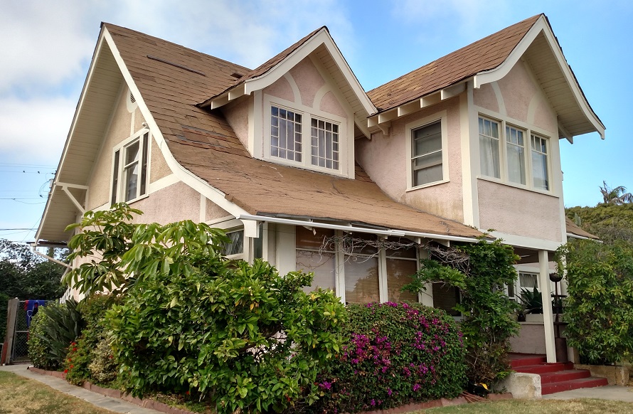
A January 1921 ad in the San Diego Union listed a house of 8 rooms, bath and sleeping porch for sale – $3000, easy terms, Mrs. V. A. Hinkle, telephone Pacific Beach 264. The home faced south, had a good garage, gas, electricity, fireplace and a fine view. The home did not sell in 1921 but Mr. Hinkle died in January 1922 and in September 1922 Mrs. Hinkle sold acre lot 36, with the Hinkle home, to Lawrence Adams. Mrs. Hinkle moved to New York City where in 1927 Mrs. F. T. Scripps, embarking for England on the Leviathan, spent a few days with friends, among them Mrs. Carrie Hinkle, an oldtime resident of Pacific Beach.

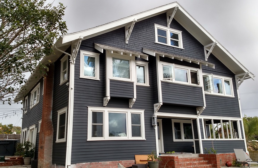
In January 1924 Mr. Adams also bought lots 21-24 of block 87 of Pacific Beach, the northwest corner of Ingraham and Law streets, and in 1926 he had the Hinkle house moved there, where it is still standing today, one of the oldest and best preserved historic homes in Pacific Beach. Adams sold both properties in 1928. In 1947 the portion of acre lot 36 now facing Law Street was subdivided as Chalcedony Terrace and the portion facing Beryl Street became Chalcedony Terrace Addition. The southerly 125 feet, the portion facing Chalcedony Street, has not been subdivided and lots there are still described as portions of acre lot 36, although the lemon trees and bees have long since been replaced by houses and apartments.

The Marshall ranches in acre lots 30 and 53 were among the properties in the eastern portion of Pacific Beach that were taken by the federal government and incorporated into the Bayview Terrace federal housing project for defense workers in 1941. They are now within the Admiral Hartman Community for military families, and although the Frank Marshall family’s house on acre lot 30 is no longer standing the site is still marked by a huge Moreton Bay fig tree that once stood over it. The T. G. Marshall house on acre lot 53, once considered the ‘finest in our colony’, is also no longer standing. It burned to the ground after being struck by lightning on Christmas Eve in 1940.

Pacific Beach Driving Park

Grandstand and clubhouse at the Pacific Beach racetrack about 1906. The central section of Pacific Beach is visible in the background beyond the track, with the former college buildings at top left (San Diego History Center photo #344)

In July 1887 the Southern California Breeders’ Association acquired San Diego Pueblo Lot 1797, a 160 acre half-mile square lot extending from what today is the intersection of Garnet Avenue and Mission Bay Drive at its northeast corner to the southwest corner of the Mission Bay High School campus. At the time this lot and Pacific Beach Company’s property to its west were entirely undeveloped, although the Pacific Beach Company would draw up a subdivision map and hold an opening sale of lots by the end of 1887. The Breeders’ Association announced that its lot would be developed as a racetrack and by September 1887 the San Diego Union reported that they were ‘pushing along operations lively’ in construction of their track and buildings.

Eastern section of 1887 Pacific Beach subdivision map showing location of racetrack and the railroad line to Pacific Beach

The buildings would include a grandstand with a frontage of 150 feet and a depth of 32 feet, a three-story judges’ stand and a club house, a very fine and convenient structure 45- by 32-feet in size, with an attic, two towers and two large bay windows giving the front a very showy appearance. There would also be a shed 100 feet long for the accommodation of teams and fifty stables, each 14 by 14 feet in size. A tight board fence, eight feet high, would surround the track. A month later, in October, the Union reported that the grading of the track and the fence were almost completed, 30 stables had been finished, the grandstand was ready for painting and work would begin the next week on the club house.

Detail from the map shows the locations of the clubhouse, grandstand, judges’ stand and stables

The grandstand had apparently been painted by November 15, 1887, when the Pacific Beach Driving Park was the scene of a baseball game between the San Diegos and the Philadelphias, or Phillies, the same National League franchise that plays there today. That morning’s Union reported that the boys from Philadelphia had arrived on the evening train and the San Diego club would cross bats with them at the Pacific Beach racetrack.  The home team had been in training for several days and the game promised to be an interesting one.  Round trip train tickets and admission to the grandstand, with special accommodations for ladies, would be 75 cents. A special train would leave the California Southern station at 1 o’clock for the park.

The November 16 Union reported that the Philadelphia and San Diego baseball clubs had crossed bats the previous afternoon and the home team was most woefully beaten, 31 – 7. The paper explained that the visitors were athletes who made a profession of playing ball while the San Diego club was a new organization only lately put in the field and the members had practiced together but once. The game was played at the new driving park at Pacific Beach and about 300 lovers of the National game witnessed the exhibition, among the spectators being a number of ladies. The game was interesting only from the fact that the spectators had an opportunity to see a first-class club play on a San Diego ball field.

Pacific Beach Driving Park had been built for racing, however, and in April 1888 the San Diego Union reported that it was being put into condition for the spring meeting. The track, built entirely of ‘made ground’, had been pronounced a good track by prominent horsemen.  The clubhouse, a three-story building of 22 rooms, was just about finished. The Grand Opening of the Pacific Beach Driving Park under the auspices of the Breeders’ Association of Southern California would include three days of racing, May 1, 2 and 3, and $1,250 in purses.

According to the Union, opening day at the new racetrack was a good day for horses, and by noon a large crowd was ‘off for the races’:

The procession which passed through the gates at Pacific Beach Driving Park was a jolly and good-natured, and expectant throng of well-dressed admirers of horse-flesh – and the pools.  They were there, all of them.  Gentlemen of leisure and gentlemen of business.  Ladies too, in their brightest array of spring colors sat in their carriages, and the throng which filled the grandstand was a lively and interested one.  The broad track over which the racers were to fly was smooth as a floor, firm, fast and in fine condition as any race-course could be.

The Union’s report on the second day of racing also emphasized the makeup of the crowd, especially the ‘fair’ members:

From early morning until afternoon the motor trains bore out their loads of merry freight, and the road to the north along the bay, was lined with carriages laden with business men, beaux and beauty, bound for the races at Pacific Park.  Every man who could get away from the busy duties of city life and evade the rules of domestic remonstrances against the seductive attractions of the uncertain pool box, donned his brightest plaid, and with dustproof hat, departed for the track.  Many there were who pleased their wives and at the same time avoided all danger of a cross-examination by taking with them the fair members of the family to enjoy the pleasures of the day.  Long before the bell had sounded the summons for the contending steeds, the carriage space of the Driving Park was well filled with a variety of gay equipages, a happy throng of pedestrian spectators moved to and fro and the grand stand presented a picture of fashion and feminine beauty.  In fact, if not in name, it was “Ladies’ Day” at the races, and the fairest of San Diego’s fair were out in all their style and bright colors of spring costumes.

The third and final day of the first race meeting at Pacific Beach Driving Park proved irresistible, according to the Union, and found the largest crowd of the season at the Pacific Beach Driving Park:

Everybody was there that could get there, and they went without much regard to the manner of their going.  They came in the closed coaches, and in the open cars of the motor, and even crowded upon the flat-cars and came out with the band. Vehicles of all descriptions were brought into use, and a constant stream of carriages poured through the gates of the Park.  There were buggies, phaetons, tandems and more than one four-in-hand in the procession, and even the “one-horse shay” was not missing, while manly equestrians and lovely equestriennes added their skillful grace to the scene of motion.  It was a great day and all had come prepared to enjoy it, so that not a cloud arose to cast its shadow over the field of pleasure – at least not until the unforeseen contingencies of the race course began to drop like a moist blanket upon the spirits of the heavy losers.

A second race meeting was scheduled for the Fall of 1888 and as that meeting approached an advertisement appeared in the Union promoting not only the Fall Race Program!, Four Days of First-Class Racing! Including running races, trotting and pacing, but also Two Extraordinary Special Days!, a Ladies’ Day and the People’s Day, which promised to be ‘the two greatest days in the annals of sport on the Pacific slope’.

As the San Diego Union had promised, People’s Day on Sunday, October 28, 1888, was a great day in the annals of sport, at least for Pacific Beach.  According to the Union, nearly 7,000 people were in attendance (out of a total San Diego population of perhaps 25,000 in late 1888). The crowd first watched a series of footraces and a blindfold wheelbarrow race before a recess was taken at noon for luncheon, ‘served in excellent style in the clubhouse’.  After lunch there were a couple of quarter-mile horse-races before the ‘event of the day’, a mounted sword combat between Captain Wiedemann and the woman who called herself Jaguarina.

Captain Wiedemann was from Germany and a leader of the local Turnverein, a gymnastic movement popular among the German immigrant population in the nineteenth century.   According to the Union he weighed 185 pounds with a chest measurement of 43 inches and biceps measuring 15 inches, and had received a thorough training in fencing. Jaguarina was described as a famous swordswoman now at Ensenada who had participated in (and generally won) similar battles in the past (her fine French military cuirasse, of brass and copper, ‘still bears deep indentations, as marks of respect from Captains Davis, Jennings and Marshal, received in former contests’).

The Union provided a blow-by-blow description of the resulting battle, which was tied after twelve rounds, each contestant having scored five points (no points had been scored in two of the rounds):

When the trumpet called the contestants to the charge for the thirteenth and last time the score stood five to five, and this final attack ended with Wiedemann aiming a cut at Jaguarina in high carte, which she parried and, before he could protect himself, ‘the sound of Jaguarina’s blade was heard on his cuirasse from a vigorous and unmistakable cut in carte’ which ended the contest with a score of six to five in favor of Jaguarina. The victor at once doffed her helmet and cuirasse and received round after round of applause from those present, many of her more enthusiastic friends throwing their caps high in the air.  After a gallop round the track with her second, Jaguarina returned to her dressing room receiving the congratulations of her friends en route.

Pueblo Lot 1797 is located at the foot of Rose Canyon, which drains a wide area extending upstream to beyond Miramar. Rose Creek normally carries the runoff from this area through Pueblo Lot 1797 and into Mission Bay but the racetrack’s location on the banks of the creek made it vulnerable to flooding from winter storms. A particularly severe storm on December 16, 1889, caused extensive flooding that washed out bridges over Rose Creek and wreaked havoc on the track.  According to the December 17 Union:

The Pacific Beach racetrack was demolished by a stream that came down Rose’s Canyon and was deflected across the north side of the grounds across the track, in the neighborhood of the Judges’ stand.  It is estimated that fully one-fourth of a mile of the track has been washed away on the east side, and several hundred feet more on the west side at the grandstand.  The water at one time was five feet deep and backed up the hill to the Pavillion.  Several of the lower sheds, down near the private gates, were also washed down.

The Pacific Beach racetrack was never fully repaired after this flood and racing never entirely recovered, but crowds still came to the grandstand to enjoy other forms of entertainment.  In November 1891 the Union reported that fully 1,000 people visited Pacific Beach to watch as a great balloon flew skyward about 2,000 feet and ‘from that giddy height a woman and monkey descended by means of parachutes’.  A triple parachute jump involving a man, a woman and a monkey and a ‘monstrous’ balloon 75 feet high and 41 feet in diameter was held at the Pacific Beach racetrack on Christmas Day 1891.

In 1890 the Breeders’ Association’s title to Pueblo Lot 1797 was challenged in court and in 1893, after a number of judicial proceedings, the property came under the control of Frederick Schulenburg, a retired lumber magnate from St. Louis. However, Schulenburg died in 1894 and in 1897, apparently in response to unpaid debts, the court ordered his estate to sell it. The Evening Tribune noted what it called ‘A Rare Opportunity’ in January 1898:

Attention is called to the legal notice in this paper offering for sale the 160-acre tract known as the ‘Race Track’ in this city.  The sale, by the administrator of the Schulenburg estate, affords the opportunity of securing a fine acreage adjoining the elegant suburban ranch homes and lemon orchards of Pacific Beach. This land is capable of producing as equally fine orchards, and a portion has been pronounced the best of alfalfa land.  The improvements alone cost more than is asked for the place.

The Union reported in September 1898 that the administrator had sold 160 acres of land belonging to the estate to a Los Angeles man, Dr. J. Mills Boal, who intended to ‘plow up’ the racetrack and set out the property to trees.  However, in November 1898, the news was that Col. A. G. Gassen had outbid Dr. Boal and became the owner of the Pacific Beach racetrack. Gassen had been involved with the Breeders’ Association and also owned other property in the area, including the brickyard in Rose Canyon. The Union added that he would spend about $2,500 for improvements intended to make the racetrack and neighboring property a pleasure resort and summer home for himself and his family.  He was expected to set out about 2,500 eucalyptus trees, build a five-board fence around the track, clear willows and other unnecessary trees and bushes from the creek bed and put part of the land into grain and alfalfa.

In May 1903 the San Diego Union reported a rumor that Col. Gassen had sold the track to A. G. Spalding, the sporting goods magnate then living in Point Loma, noting that the track had at one time been one of the finest speedways on the Pacific coast but had fallen into disrepair and would have to be wholly rehabilitated to become what it once was. Albert Goodwill Spalding was a former professional baseball player who in 1876 had founded the A. G. Spalding & Bros. sporting goods company which made baseballs and, in 1877, the first baseball gloves, which he was one of the first players to wear. Spalding and his second wife, an ardent Theosophist, moved to Point Loma in 1903 to participate in Katherine Tingley’s Lomaland Theosophical community.

Although the rumor of the track’s sale was false, or at least premature, Spalding’s interest apparently inspired Gassen to consider rehabilitating the track. In June 1903 the Union reported that he was having the track overhauled and more stalls built in anticipation of reopening in the fall and winter.  Fifty or sixty fine animals from Kentucky and Illinois would winter there, with the possibility of many more joining them during the cold season. Gassen said it was ‘not improbable’ that there would be a number of meets involving the eastern and local horses. He did not expect that the track would require a great deal of work to put it in proper shape and the fence, which had been out of repair for some time, had been repaired and painted and the grandstand and judges stand had also been fixed up. A new organization, the Belmont Breeders Association, was incorporated and Gassen tried to convince the Santa Fe Railroad to build a siding to the track so that horses could be unloaded at the stables.

The first shipment of the eastern horses arrived in September 1903, but the big news, a few weeks later, was that Spalding had taken over the Belmont Breeders’ Association and the track and stables of the Pacific Beach racetrack. The name was to be changed to the American Saddle-Horse Breeding Farm and the track to be hereafter known as American Park.  The Tribune noted that Mr. Spalding had always been an admirer of the American or Kentucky type of combination gaited saddle and driving animals and ‘the breeding of this high class of horses will be the special purpose of the establishment’. However, the saddle-horse breeding venture was not successful and was abandoned later the same year. Although the newspapers had referred to Spalding’s take-over of Gassen’s Belmont Breeders’ Association as a purchase or buy-out, the transaction apparently did not include the racetrack property itself and there is no record of any actual transfer at the San Diego County Recorder’s office. Gassen had retained ownership and in November 1904 granted ‘all of that certain property known as the Pacific Beach Race Track’ and other property at the mouth of Rose Canyon to U. S. Grant, Jr., son of the Civil War general and former president.

The track continued to be neglected, although in March 1906 the Union reported that while not much had been done with the track of late years it was still in good condition. There was a club house and grandstand on the grounds, the latter having a good seating capacity, and the accommodations at the track were first class in every respect. However, in October of that year another Union headline announced that the Pacific Beach Track had been sold For $75,000.00; this time U. S. Grant, Jr. had sold Pueblo Lot 1797, popularly known as the Pacific Beach race track, and other adjoining property to Archibald Hart, who intended to divide the property into villa lots and city lots. In November 1906 Hart and others incorporated the Mission Bay Park Company to lay out, improve and beautify their acquisition, particularly that part known as the Pacific Beach Race Track. The racetrack itself was to be eliminated; beginning in early 1907 the railroad that had serviced Pacific Beach since 1888 and had originally circled around the track via what today are Mission Bay Drive and Garnet and Balboa avenues (all then called Grand Avenue) was realigned along the route of today’s Grand Avenue (then called Ivy Avenue), cutting through the area where the track had once been.

The map of the Mission Bay Park tract filed in February 1907 subdivided the property in much the same grid pattern as that of the Pacific Beach subdivision to its west, including extensions of Hornblend, Ivy, Thomas, Reed, Oliver and Pacific Avenues from Pacific Beach and new streets like Figueroa Boulevard, Magnolia Avenue and Bond Street. Curiously, the Mission Bay Park subdivision map did not include Rose Creek, a stream which flows through the center of the tract and during wet winters in the recent past had inundated much of it. Today the Rose Creek flood control channel runs through the subdivision on what was originally laid out as Pico Street.

However, the Mission Bay Park Company failed to effectively develop or market its tract and the only property sale recorded was for lots 6, 7 and 8 of block 29 and lots 1, 2, 3 and 30 to 33 of block 32, the locations of the actual structures remaining from the former racetrack; the judges’ stand, club house and grandstand. This parcel was sold in March 1907 to Ye Olde Mission Inn Company, a corporation set up in February 1907 by James H. Babcock and others. The clubhouse became known as the Mission Inn and a year later, in February 1908, it narrowly escaped destruction when volunteers using a garden hose and bucket brigade prevented fire at a nearby shed from spreading to the hotel ‘formerly used by the racetrack people as a club house’. One of the volunteers was former San Diego fire department chief A. B. Cairnes, who lived in a home overlooking the racetrack property and who naturally responded to the sight of smoke and flames. However, the Mission Inn caught fire again later the same year, in November 1908, and was completely destroyed.

Unable to interest prospective buyers in their tract, the Mission Bay Park Company transferred it back to U. S. Grant, Jr. in November 1908, minus the 1.25-acre Mission Inn property, which was auctioned at the courthouse door in February 1912. The structures remaining on the site were abandoned and fell into disrepair. The San Diego Sun reported in 1931 that the ruins of the grandstand and the stables were still to be found ‘almost hidden by the rank vegetation of two score years’.  Aerial photos of the area from 1941 show the outlines of some of the streets laid out in the Mission Bay Park subdivision map but little actual development and no trace of anything resembling the former mile-long oval racecourse.

The Federal Public Housing Authority took over much of the property of the Mission Bay Park tract in 1941 and parts of the Bayview Terrace Project for wartime defense workers and Bayview Terrace (now Barnard) Elementary School were built on the western portions.  The southern portion of Pueblo Lot 1797 eventually became Mission Bay High School, the Mission Bay Athletic Fields and the back nine of the Mission Bay Golf Course.  One structure from the track itself, a three-story wooden judges’ stand, remained standing and was incorporated into the Rancho 101 Motel on Pacific Highway (Mission Bay Drive) in 1947.  The motel (and judges’ stand) was finally demolished in 1968, eliminating the last remaining trace of the former racetrack in Pacific Beach. The block west of Mission Bay Drive between Magnolia Avenue and Hornblend Street where the club house, grandstand and judges’ stand once stood and where thousands of nineteenth century San Diego sports fans once gathered to enjoy races, baseball games, mounted sword combat and parachute drops is now (2020) occupied by an automobile dealership.


Hidden History in Acre Lot 50

Acre Lot 50, Pacific Beach, in the 1930s (San Diego History Center 83:14603-1)

In February 1892 R. C. Wilson and G. M. D. Bowers, brothers-in-law and business partners from Henning, Tennessee, purchased Acre Lots 34 and 50 of Pacific Beach and in March 1892 added Acre Lot 33, lots that met at the corner of what are now Chalcedony and Lamont streets. The price was $100 an acre; $1850 for lots 34 and 50 and $990 for lot 33. These acre lots originated in an amended subdivision map recorded by the Pacific Beach Company in January 1892 that partitioned Pacific Beach north of Diamond Street (and south of Reed Avenue) into ‘acreage lots’ of approximately 10 acres, intended for agricultural use. By the end of March 1892 a six-inch water main had been laid up Lamont as far as Chalcedony and the San Diego Union reported that Wilson and Bowers were having 4,000 feet of water pipe laid over their 30-acre tract. The Union added that the property was to be put in lemons during the next few weeks. Other purchasers also acquired acre lots in the vicinity and Pacific Beach soon became a thriving center of lemon cultivation. On Acre Lot 34, west of Lamont between Chalcedony and Beryl streets, the Bowers built the first lemon ranch house in Pacific Beach in 1892, a house which is still standing at 1860 Law Street. The Wilsons built in 1893 on Acre Lot 33, on the other side of Lamont. Their ranch house was razed in the 1940s but a large Moreton Bay fig tree that once stood over it still marks its location.

In 1895, having developed their properties into a profitable lemon ranch, the partners sold them and returned to Tennessee. Lot 33, including the Wilsons’ home, was sold for $5500, lot 34, with the Bowers’ home, also sold for $5500 and lot 50, with no improvements at the time, went for $3000. The purchasers of Acre Lot 50, east of Lamont Street between Chalcedony and Diamond streets, were Lewis and Elizabeth Coffeen, recent arrivals from Michigan. They built a ‘fine cottage’ on their new possession which the city assessed at $100 and in December 1895 the Union reported that they had moved into their new house. This house is also still standing, at 1932 Diamond Street. However, the Coffeens did not live in the fine new cottage for long; he was compelled to return east for business reasons and the ranch was sold in March 1897 to Major William D. and Henrietta Hall.

According to the Union, Maj. Hall, a new arrival who spent three years in Phoenix, Ariz. seeking restoration to health, was induced to visit Pacific Beach to examine a ten-acre improved tract by an advertisement in the Union. Three days after first sight, Maj. Hall was the proud possessor of a four-year-old lemon grove, beautiful for situation, commanding a view of Mission Bay, the breakers at Ocean Beach, Point Loma, San Diego city and Coronado. He had already erected a curing house and had a hundred boxes of lemons packed therein. Maj. Hall was reportedly delighted in the soil, location, climate and environment and especially the price of water, for which he said he paid as much for his ten acres as he would have paid for an acre and a half in Phoenix. At the end of 1897 the Union reported that Maj. Hall had received $200 from the abandoned orchard that he took charge of ten months earlier and in June 1899 it reported that he netted $100 from a picking of four acres of lemons. Presumably he used the proceeds for the ‘quite important additions and improvements’ made to his house in December.

On New Year’s Day the San Diego Union regularly featured articles celebrating each of the outlying communities and on January 1, 1900, the article from Pacific Beach was written by Wm. D. Hall. According to Maj. Hall, Moses’ view of the promised land from Mount Pisgah could not be compared with the view of Pacific Beach from Point Loma, and nearly in the center of this beautiful spot were clustered about three hundred acres of lemon groves from three to seven years old and from 2 ½ to 10 acres, dotted here and there with fine residences with well kept yards, beautiful with every variety of flowers and in bloom all year round. He noted that the Pacific Beach lemon groves were not only attractive but productive; during the past year thirty carloads of lemons (and two of oranges) had been raised and shipped. However, like Wilson and Bowers, Maj. Hall apparently decided that there was more profit to be made selling the groves than the lemons and in 1899 the Halls sold about half of Acre Lot 50, the northern 298 feet, with 12 rows of trees running east and west, to A. F. and Margaret Roxburgh. In 1901 the Halls sold the other half, the southern 322 feet including their home, to R. M. Baker.

The Roxburghs were from Scotland and had come to Pacific Beach to join her brother William Kyle who had established a poultry ranch in Pacific Beach, specializing in ducks. Kyle was also an elder and Sunday School superintendent at the Pacific Beach church; the Union reported that the Santa Claus who entered through a church window and distributed gifts to the children on Christmas Eve in 1896 had a broad Scotch accent. His sister and her husband arrived in February 1899 and in June of that year Mr. Kyle’s and Mrs. Roxburgh’s mother also arrived from Scotland. Kyle, his mother and the Roxburghs initially rented rooms at the College Inn, originally the home of the San Diego College of Letters but used as a rooming house after the demise of the college in 1891. Once they had acquired their ranch in the north half of Acre Lot 50 the Roxburghs moved out of the inn and for several years lived in houses on neighboring lemon ranches including Mary Rowe’s on Acre Lot 49 in 1900, R. P. Dammond’s in Block 180 in 1902 and Harold Scott’s on Acre Lot 35 in 1903. In 1904 they built a house on their own ranch which the Evening Tribune described as both substantial and artistic looking, being built largely of stone. This house is also still standing, at 4775 Lamont, although it is set back from the street and nearly hidden by surrounding structures.

The Roxburghs did not live in their new home for long either; in 1906 they sold their portion of Acre Lot 50 to M. F. Chesnut, a real estate investor, who sold it the following year to Folsom Bros. Co. At the time Folsom Bros. owned most of the property in Pacific Beach and was engaged in improvement projects, particularly grading streets and pouring concrete sidewalks, which they hoped would attract purchasers and increase the value of their holdings. In 1912 the property was purchased by Alfred Hatch Brown, who also extended his ranch with a strip of land 125 by 250 feet just across Chalcedony Street in Acre Lot 33. Mr. Brown and his wife St. Claire Brown lived in the stone ranch house until they moved downtown in 1918, after which they rented out the house and land. The lemon boom had faded years earlier but this irrigated ranch land was ideal for vegetables and the tenants were mostly truck farmers, some of them Japanese immigrants. Arthur Yamaguchi occupied the house in 1920 and Yatoro Yamaguchi and his family lived there between 1929 to 1931, paying $40 a month rent. The Y. Yamaguchis and their American-born children were still living in Pacific Beach in 1942 and were among those sent to the Poston relocation center for ‘enemy aliens’ in Arizona during World War II.

The south half of Acre Lot 50 had been sold in 1901 to R. M. Baker, who had also acquired two other lemon ranches and a half-interest in the main lemon packing plant on the Pacific Beach and La Jolla railway line at the corner of Hornblend and Morrell streets. However, he also didn’t hold that property for long and in July 1902 sold it to Peter and Mary Vessels. In May 1908 the San Diego Union reported that Mrs. Vessels attended a city council meeting and spent half an hour asserting her rights over the removal of a hedge fence which stood in the way of the grading of Lamont Street being carried out by Folsom Bros. Co.  According to the San Diego Union she told the councilmen that she would position herself on the fence and the only way they could get her off would be to push her off and plow her under. After a ‘spicy encounter’ between the fence owner and the vice-president of Folsom Bros. and a ‘long and tiresome debate with Mrs. Vessels in the lead’, the council passed a resolution directing the city engineer to enforce the grading of Lamont Street to the full width thereof including the sidewalks (and presumably any hedge fences that encroached on it). Lamont Street was graded, apparently without injury to Mrs. Vessels, and in October 1909 cement sidewalks were laid along Lamont, including a section in front of the Vessels property between Diamond and Missouri streets that still exists today .

In 1911 the Vessels began selling off portions of their property in the south half of Acre Lot 50, first the southeastern quarter and then the northeastern corner. Unlike most other acre lots in Pacific Beach, Acre Lot 50 was not re-subdivided into blocks and lots and these transfers were described as the easterly 275 feet of the southerly 135 feet and the easterly 100 feet of the northerly 135 feet of the southerly 270 feet of Acre Lot 50 (most property within Acre Lot 50 is still described in this manner). In 1916 the Vessels granted the city a strip of land 52 feet wide at the northern edge of their property, intended as a continuation of Missouri Street. The city did not receive a corresponding grant from the owner of the north half of the lot and as a result the continuation of Missouri Street today is not aligned with the street to the west and is much narrower (also, unlike most Pacific Beach blocks, there is no alley in the south half of Acre Lot 50). In 1917 the Vessels sold the southwestern 200 feet along Diamond Street and the northwestern 455 feet along Missouri Street, about three-quarters of their property, to Jesse and Lena Pritchard, leaving the Vessels with a 105-foot lot on Diamond which went to their daughter Blanche Vessels Lane. The house originally built for the Coffeens was included in the southwestern 200 feet of the lot but the Pritchards did not live in it. Instead it was rented, including, in 1919, to Yataro Yamaguchi, the Japanese truck farmer who later moved into the Roxburgh house.

In 1920 the southwest corner of the acre lot, including the Coffeen ranch house, was sold to George and Mary Churchman, who took up residence there and remained for over fifty years. George Churchman was a San Diego police officer who began with the bicycle detail and advanced to be head of substations in Ocean Beach and La Jolla and for a time during the prohibition era was in charge of the police vice squad. In one sensational 1921 incident (‘Bluecoat shoots 2 in dark store’), Patrolman Churchman shot a pair of burglars, killing one, after being struck in the head by a tire iron and threatened by a shotgun, which fortunately wasn’t loaded. While trying to ‘dry up’ the Sunset Supper Club while in charge of the Ocean Beach substation in 1925 Sergeant Churchman found a 23-year-old woman sitting on a bottle of gin and a 26-year-old woman with a bottle of gin ‘parked’ between her feet. A 26-year-old man approached, showed him a roll of bills, and offered him $50 to ‘forget about it’. All three were placed under arrest.

In April 1929 Churchman was elevated from sergeant to lieutenant and put in charge of the vice detail. A few months later, in August, the ‘dry squad’ led by Lt. Churchman raided a storeroom downtown and seized 4500 quarts of whisky, gin and other liquors worth $27,000. The illicit beverages had apparently been brought in for an American Legion state convention and there was a widespread belief that the Legion’s ‘irrigation committee’ thought that the police had been ‘fixed’. At the trial a witness testified that ‘someone got sore at the Legion’ and gave a tip to Churchman; if the tip had gone to the mayor or the chief of police the raid would never have happened. Churchman also led a raid that uncovered an illicit 200-gallon still and two 800-gallon mash vats in a house in Loma Portal.

However, in 1931 the vice squad came under attack by the bar association after a woman was arrested and held in jail over the weekend without being permitted to post bail. The San Diego Union reported that Lt. George Churchman, head of the vice squad, had determined that she was a ‘woman of a disreputable character’ and deemed it wise to hold her without bail until he could check up on her story (she was eventually charged with vagrancy but the charge was dismissed). The bar association threatened damage suits against the vice squad members, including Churchman, involved in what it called illegal arrests. Two members of the city council joined in denouncing the police department and demanded a general vice cleanup. The police chief resigned, claiming that his job had been made impossible by political interference, and Churchman was reassigned to head the La Jolla substation. After he also resigned from the police department he continued to be involved in security work, including the security of Camp Callan, on Torrey Pines Mesa, during the war years. He also continued to live in Acre Lot 50 until the early 1970s when he moved a block down the street to the new Plaza apartments.

By the mid-1930s the south half of Acre Lot 50 had been divided into a number of separate parcels and there were 5 residences existing along Diamond, Lamont and Missouri streets. However, the northern half had remained intact with the Roxburgh ranch house as the only residence. In 1937 the northern 125 feet, including the house, was sold to a construction company, but no additional homes were built until the 1940s. In 1940 Consolidated Aircraft began production of its B-24 Liberator bomber and hired tens of thousands of workers for its factories around the San Diego airport, creating a  demand for housing in nearby areas like Pacific Beach. In 1941 the federal government built over 1000 temporary homes in the Bayview housing project just a few blocks east of Acre Lot 50 and commercial developers also began building affordable homes in the area for the new workers. There were still only 9 homes in Acre Lot 50 in 1941, 4 on Diamond, 2 on Lamont and 3 on Missouri but 6 more were built by 1945. By 1950 there were 20 homes, 9 on Diamond, 5 on Lamont and 6 on Missouri, but still none on the south side of Chalcedony Street. In 1950 Pacific Beach contractor Stanley Picard acquired this property, the northern 125 feet of Acre Lot 50 except for the 75-by-130 foot space around the Roxburgh ranch house, and in 1950 this parcel was subdivided as Picard Terrace. By 1955 eight homes had been built along Chalcedony Street in Picard Terrace and more than 20 addresses were listed in the 1900 block of Missouri. Like most of the rest of Pacific Beach, Acre Lot 50 was fully built out before 1960 and since then many of the first generation of single-family residences have been converted to multi-unit apartments and condos, but Acre Lot 50 has the distinction of having preserved not one but two of its original lemon ranch houses, even if they are well hidden.

Acre Lot 50 today (Google Maps satellite view)

The Implausible Railroad

Last month the Pacific Southwest Railroad Museum staged a reenactment of what was considered the greatest event in the history of San Diego when it took place a century ago. On November 15, 1919, in a remote desert canyon, J. D. Spreckels, founder and president of the San Diego & Arizona Railroad, drove the golden spike that symbolized completion of a new rail line linking San Diego with the Imperial Valley and points east. Speakers impersonating the dignitaries who spoke at the original ceremony emphasized the difficulties involved in building the line, which had already become known as the ‘impossible railroad’, and praised Spreckels for his determination in leading the effort that finally overcame the many challenges – for doing the impossible.

Work on the SD & A had begun in 1907 but a number of difficulties, principally the challenging terrain along the planned route, had stretched construction out for over twelve years. The most challenging section of the route was in Carrizo Gorge, north of Jacumba, where for 11 miles the SD & A right-of-way was blasted out of a sheer canyon wall, requiring 17 tunnels totaling 2 ½ miles in length and 14 wood trestle bridges. In November 1919 construction crews laying track from both ends of Carrizo Gorge finally came together and Spreckels and a trainload of the city’s leading citizens congregated there to celebrate his triumph by driving in the last spike. However, the 2019 reenactment of this historic occasion did not occur at Carrizo Gorge, which has been closed to passenger rail service for nearly 70 years, but instead at a railway museum in Campo where railroad enthusiasts can still ride in vintage coaches with SD & A lettering over the few miles of the route that are still open. The audience was well aware that the reenactors’ tributes to Spreckels for doing the impossible were ironic, and that the railroad turned out to be impossible after all.

Passenger service over the new railroad line was inaugurated on December 1, 1919, but after only six weeks, in January 1920, the San Diego Union (which was also owned by Spreckels) reported that a rock slide, not large enough to do any ‘real damage’ but just large enough to prevent temporarily the passage of trains, occurred on the SD & A in Carrizo Gorge. The landslide was just west of Tunnel No. 13 and the railway stated that this particular point had been questionable for some time and dynamiting had been considered, so the slide actually relieved the company of this trouble. The Evening Tribune (also owned by Spreckels) added that although nature had ‘saved the powder’ the line was still blocked and passengers on the westbound train No. 3 and eastbound train No. 4, which had arrived at opposite ends of the slide, had to be ‘transported’ around the slide to the other train, which then reversed course and took them on to their destinations. Despite this inconvenience, the railway company emphasized that the track through Carrizo Gorge was becoming more settled each day and was in a very satisfactory condition, and there should be no trouble from this time on. This optimistic assessment was reinforced a month later, in February 1920, when the Union reported that rainfall in the mountain regions was heavy enough in Carrizo Gorge to put the new roadbed to the test that had been awaited by railroad officers. The many precipitous water courses that the rails passed over flowed strongly during the storm but since the many tunnels, cuts and trestles successfully withstood the forces of the first big storm no future trouble of any kind was looked for.

Future trouble occurred anyway, and it was of the kind that did cause real damage. The Union reported in May 1920 that a slide on the side of a mountain over tunnel No. 7 in Carrizo Gorge would probably put the San Diego & Arizona railway out of commission temporarily; although the tunnel was open and trains could be operated through it that was not considered advisable until the part that had given way was removed, which would require several days. Arrangements had been made to transfer passengers between Campo and El Centro by automobile. According to the railway this was the only tunnel through the gorge that had given trouble of any consequence. Two days later, however, the report was that a rift in the rock formation had caused a shift of a huge mass of rock and earth bearing down on the west end of tunnel No. 7. A section of the mountainside 590 feet long, 200 feet high and 200 feet wide at the west portal of the tunnel was unstable and was sliding downhill, crushing 128 feet of the tunnel and 480 feet of track leading to the tunnel. Blasting would be required to break down practically the entire side of the mountain. This would close down the line for a period of five weeks and cost the company approximately $250,000 but, on the plus side, would make impossible any recurrence of the trouble and make the tunnel absolutely safe for all time. A big steam shovel with a force of about 100 men was already at work on the west end of slide. Another shovel with its crew, based a few miles west of the slide, had started a roundabout trip of about 430 miles via Colton and El Centro in order to reach the east end of the slide.

Blasting off the side of the mountain required miners to sink three shafts 25 to 35 feet deep near the top of the slide and oil-drilling rigs to drill six holes 50 to 60 feet deep near the roadbed.  These were filled with 50 to 60 tons of black powder and dynamite and in early June J. D. Spreckels himself made the trip to Carrizo Gorge by special train to throw the switch setting off the blast. According to the Evening Tribune, there followed a heavy roar with a concussion that rocked the ground. Vast clouds of dust were sent skyward and thousands of tons of rocks and boulders went hurtling and bounding into the canyon below. Good results were obtained, although not entirely up to expectations, and no accidents of any kind were recorded. A film crew was on hand when the big blast occurred and a few weeks later citizens of San Diego were able to watch it on the big screen; the ad in the Union read ‘Blown Up! A Whole Mountain to Make Carriso Gorge Safe on the S. D. & A. Railroad. See the Big Blast at the Cabrillo. Now — This Week.

However, debris from the Big Blast and a subsequent shot still had to be cleared away and the tunnel rebuilt and two months later the railroad reported that progress had been much slower than expected. Four steam shovels were working two full shifts and the obstruction had been cleared up to approximately 100 feet from the tunnel portal. The railroad predicted that the line should be handling traffic by the end of August and denied a statement in the Los Angeles Examiner that the blasts had been a complete fiasco since the many tons of earth and rock thrown clear of the roadbed had reduced the material to be handled by the steam shovels. The end of August came and went and in October the railroad announced that although the slide had been cleared and the roadbed widened it would still be necessary to drive 166 feet of new tunnel to connect with the present tunnel, possibly by mid-November.  When the line did reopen on Thanksgiving Day after being closed for seven months an editorial in the Union declared that every possibility of future delay by reason of similar obstruction had been permanently removed and henceforward San Diego would serve as the Pacific terminal of a direct transcontinental railway.

Actually, other possibilities for delays still existed and in August 1921, less than a year later, the line was closed for several days after heavy and sudden rain hit the western side of Imperial Valley. The terrific downpour had caused 20 washouts along a stretch of about nine miles there leaving a much weakened roadbed in its path. After another storm in December 1921 good progress was reported on repairs to the SD & A roadbed at washed-out points between Tijuana and Carrizo Gorge, although several more days would be required to open the line to through traffic. Through service was restored early in January 1922 but trains were required to travel slowly over three of the washouts so the train making a connection with the Golden State at Yuma would have to leave San Diego an hour earlier than regularly scheduled (at Yuma a sleeper car from the SD & A train was switched to the Southern Pacific’s Los Angeles to Chicago Golden State Limited so that a passenger could go all the way from San Diego to Chicago in the same car). Closures of several days also occurred in December 1926 at the edge of Imperial Valley, February 1927 between San Diego and Tijuana, and September 1929, when 11 miles of track in Carrizo Gorge and 18 miles in the desert approach to the gorge had to be repaired after a cloudburst.

1932 turned out to be an even worse year for the SD & A. In January a fire was discovered in Tunnel No. 3, located south of the Mexican border between Tecate and Campo. Heavy smoke and heat from the flames prevented fire crews from entering and the railroad announced that all traffic would be diverted through Los Angeles until the fire burned itself out, possibly after several days. When the fire had burned out and the tunnel cooled crews began removing debris and installing new timbers, around 1,500,000 board feet of redwood, which had arrived by ship from Northern California. One shipment of nearly 1,000,000 feet from Fort Bragg, including huge squared balks of redwood, four-by-sixes and planking, was unloaded at Pier 1 in San Diego and taken to the tunnel on 50 flat cars. Tunnel No. 3 had originally been 1296 feet long but a section near the east end had collapsed as a result of the fire, ‘daylighting’ that section and dividing the tunnel into two sections, to be named Tunnels No. 3 and 3 ½. Crews finished retimbering the tunnels at the beginning of March 1932 and service was resumed after six weeks and an estimated cost of $100,000, not counting loss of revenue.

In late March 1932, three weeks after the line was reopened at Tunnel No. 3, a slide apparently due to heavy mountain rains blocked the line of the SD & A at the east portal of Tunnel No. 15 in Carrizo Gorge and traffic was again rerouted through Los Angeles. Although the initial report was that the trouble was temporary and service would soon be resumed, the mountain continued to slide and it became apparent that Tunnel No. 15 could not be repaired and the tracks would have to be realigned around it. The realignment would include a new, shorter Tunnel No. 15 and a curved trestle bridge 633 feet long and 185 feet above the canyon floor. The trestle was also built of redwood and is said by some to be the largest curved wood trestle in the world. It is certainly spectacular and has since become a symbol of the SD & A line.

Construction work on the Tunnel No. 15 realignment was completed and the line reopened in early July. However, in October 1932 the railroad experienced another tunnel fire, this time in Tunnel No. 7 in Carrizo Gorge, the same tunnel that had caused problems in 1920. Again there was no possibility of fighting the fire and instead both entrances to the tunnel were sealed in an effort to snuff it out, and traffic was rerouted through Los Angeles. Once the fire had burned out and the tunnel cooled enough for inspection, railroad officials determined that it too was beyond repair and would have to be abandoned. The roadbed was realigned in a series of sharp curves 2200 feet long that bypassed the abandoned tunnel and the line reopened in January 1933 after having been closed for more than half of 1932.

J. D. Spreckels had founded and initially owned the SD & A but had required financial support from the Southern Pacific railroad for its construction. In 1916 the Southern Pacific recovered a portion of this outlay by taking a half-interest in the SD & A. Spreckels died in 1926 and in 1932 his estate’s remaining half-interest was also acquired by the Southern Pacific. While wholly owned by the Southern Pacific, the railroad was operated as a separate unit and renamed the San Diego & Arizona Eastern Railway, or SD & AE. The sale was finalized in February 1933 and the SD & AE operated relatively successfully for a number of years thereafter, particularly during the war years of the early 1940s when there was a heavy flow of materiel and military personnel to the port and military bases around San Diego. However, more people were driving cars and more and better highways were being built, including US Route 80 which duplicated the route of the SD & AE between San Diego, the Imperial Valley and the east. Commercial aviation was also improving and attracting growing numbers of passengers. In the years after the end of the war in 1945 traffic on the SD & AE declined and in 1952 passenger service was abandoned.

Freight service continued, although not without incident, especially in Carrizo Gorge, where the rough road and sharp curves made the line prone to derailments. One particularly memorable derailment occurred in May 1965 and closed the line for several days. According to the San Diego Union, one car loaded with wine from New York state was destroyed to prevent looting and two truck trailers with 72,000 cans of beer slid from a flat car 600 feet into Carrizo Gorge (in the following months 24 persons were apprehended in quest of free beer).

In September 1976 tropical storm Kathleen drenched San Diego’s east county and the Union reported that a torrent of water ripped through Carrizo Gorge to destroy portions of three bridges supporting the SD & AE railway. Two trains had been turned back and it would be at least two weeks before rail service was restored. In fact service was not restored until December 1982, over six years later. In the meantime the Southern Pacific sold the railway to San Diego’s Metropolitan Transit Development Board which wanted the SD & AE’s suburban rights of way for the light rail system that became the San Diego Trolley. One of the conditions of sale was that the Southern Pacific had to restore the line to service, but just a week after service was restored another storm dropped 2 inches of rain on the desert approach to Carrizo Gorge near Ocotillo and blocked the route again with tons of rocks and landslides. Six months after that damage was cleared a brush fire in June 1983 burned two trestles and threatened a tunnel in Carrizo Gorge. Although the tunnel did not sustain serious damage, the trestles were destroyed. Fires in tunnels No. 16 in 1986 and No. 8 in 1988 further damaged the line in Carrizo Gorge and Tunnel No. 3 in Mexico caught fire again in 1999. This damage was eventually patched up (Tunnel No. 3 was ‘daylighted’) and the line was open for occasional freight service between 2004 and 2008, but it is now inactive except for the short excursions around Campo. The ‘impossible railroad’ still has its boosters, however, and J. D. Spreckels would have been proud to hear one of the speakers at the centennial celebration declare that the line would be open again next year.

Hauser’s Subdivision in PB

Aerial photo showing Hauser’s subdivision (and military academy barracks) in the 1930s  (from San Diego History Center photo 83:14603-1)

In October 1889 the San Diego Union reported that Mrs. Mary E. Rowe and her charming daughters Miss Mabel and Eva were stopping at the Horton House hotel downtown. The Rowes were on their way to Pacific Beach, where the girls, then in their mid-teens, would become students at the San Diego College of Letters. Pacific Beach had been founded in 1887 and was not even two years old at the time. The college, which the founders hoped would become the nucleus of a refined and cultured community, had opened in 1888 and was beginning its second year. It was located on what was then College (now Garnet) Avenue where the Pacific Plaza shopping center is today.

The Rowe family had spent years in India, where Mrs. Rowe’s husband served as a missionary and where Evangeline (Eva) and her younger sister Nellore (Nellie) and brother Percy had been born. They returned to the United States after Rev. Rowe died of typhoid, and once in Pacific Beach acquired a home on the ocean front at the foot of College (the site that was later Maynard’s bar and is now the See the Sea condominiums). In the summer of 1890 the college newspaper reported that the students were enjoying their vacations in ‘divers and sundry ways’, including an evening passed pleasantly telling ghost stories at Mrs. Rowe’s ‘cottage by the sea’, with Misses Mabel and Evangeline doing the honors.

However, the college’s second year turned out to be its last. Its financial position had deteriorated and many in the administration and faculty resigned over the summer. The college did begin the fall term in September 1890 but it never reopened after the Christmas holidays. After the collapse of the college many of the people it had attracted to Pacific Beach moved on, but some remained and were instrumental in relaunching Pacific Beach as a center of lemon cultivation. One who remained was E. C. Thorpe, whose daughter Lulo had also been a student (and whose wife, Rose Hartwick Thorpe, was famous as the author of the poem Curfew Must Not Ring Tonight). Mr. Thorpe remembered those times in an article for the San Diego Union in 1896:

At the close of the college as an institution of learning in 1890 many of those to whom this had been the attraction moved away, and the following year but three or four families remained in the college settlement. In the fall of 1891 the tract was placed upon the market as acreage property, and in a few weeks a force of workmen were clearing the first hundred acres preparatory to planting lemon orchards. Rabbits and rattlesnakes were driven back to mesa and canyon, and the sunny southern slopes were soon clothed in fragrant lemon foliage.

Among those families from the former college settlement that settled on the sunny southern slopes and became lemon ranchers was the Rowe family. As Thorpe had recalled, an amended map of Pacific Beach was filed in 1892 that re-subdivided most of Pacific Beach north of what is now Diamond Street (and south of Reed Avenue) into ‘acre lots’ of about 10 acres. In April 1892 Mrs. Rowe purchased one of these acre lots, Lot 49, containing 8 6/10 acres, for $860 or $100 an acre. Acre Lot 49 was located between what are now Diamond and Chalcedony streets and west of Lamont. Mrs. Rowe also apparently had her ‘cottage by the sea’ moved onto her new property; the $400 improvement assessed on her lots in block 226 in 1893 was no longer there in 1894 but there was a $400 improvement assessed on Acre Lot 49.

The ’sunny slopes’ north of the college campus turned out to be ideal for lemon cultivation and the lemon ranches established there flourished. The Union reported in 1895 that Mrs. Rowe was daily improving her place (and also that the society of her daughters was much sought after on account of their charming qualities). A Horticultural Notes column in 1897 included the note that Mrs. Mary E. Rowe had a ranch that from the raw condition had been developed to one now valued at $9,000; ‘The ladies of Pacific Beach are justly proud of their ranches’. In 1900 the report from the Union was that Percy Rowe was in charge of the ranch and had recently done much to improve its condition; ‘It is no little task for a lad to tackle a ranch which needs so much renervation, but pluck and industry generally win’ (Percy would have been about 20 at the time).

The Rowe girls had come to Pacific Beach for an education and after the college closed they continued their studies in the public schools. The only high school in San Diego at the time was the Russ School downtown (now San Diego High), and students from Pacific Beach could take the train from the station at the corner of Lamont Street and Grand Avenue, a few blocks from the Rowe ranch. Evangeline Rowe appeared in the second row in a photo of the Russ School graduating class of 1894. After graduation Mabel and Evangeline Rowe went to Los Angeles to further their educations. Evangeline attended the College of Medicine at the University of Southern California where she met and married Dr. Charles Caven. Evangeline Rowe Caven graduated with a medical degree in 1898 and the couple briefly returned to Pacific Beach before moving back to Los Angeles, then on to Bisbee in the Arizona Territory.

In 1898 the Jowett family had purchased the lemon ranch on Acre Lot 34, which lay across Chalcedony Street on the north side of the Rowes’ ranch. The Jowetts also had children of about the same ages as the Rowes and the neighborhood kids often got together. On one occasion the Union reported that a wagon-load of sea moss with its surface bristling with young people from Pacific Beach had arrived and had dinner on the rocks at La Jolla, after which a musical program was rendered at the pavilion, followed by dancing. The party returned home at a late hour; those present included the Misses Nellore Rowe and Ruth Jowett and Messrs Percy Rowe and Oliver Jowett. Although Mabel Rowe was missing from this particular party (she was studying in Los Angeles), she did return home on occasion and apparently became acquainted with Oliver Jowett. They were married in Los Angeles in 1900, although they later divorced and ‘O. J.’ remarried in 1909.

Nellore Rowe graduated from the Russ School in 1898, was certified as a kindergarten teacher in 1899, and was teaching school in National City in 1900. She later moved to Bisbee, where her sister Evangeline was practicing medicine, and in 1908 married William Gohring, superintendent of mines for the Calumet and Arizona Mining Company. The Gohrings moved to Phoenix in 1918, where he was an executive of the Arizona Copper Company.

The Cavens came back to San Diego in 1910, living in a house on Quince Street at the western end of the Quince Street footbridge (which had been finished in 1907). When the Panama-California Exposition opened in Balboa Park in 1915 Dr. Charles Caven was appointed the official physician and while there he made the news as perhaps the first opioid overdose victim in San Diego history. According to the Evening Tribune he was found in a semi-conscious condition in a garden near the California Building and taken to the Exposition hospital where he died of what the attending physicians determined to be an overdose of morphine (friends said he had no reason to be taking morphine and they believed he took it by mistake). Evangeline remained in San Diego and in 1919 joined a group of doctors, nurses and child welfare workers who traveled to Serbia to assist orphans from World War I. She eventually returned to San Diego where she purchased property overlooking a canyon at the corner of Brant and Upas streets and lived in the home now known as the Evangeline Caven bungalow. She later moved to Los Angeles where she lived with her sister Mabel.

Back in Pacific Beach, Mary E. Rowe had sold Acre Lot 49 with her home and lemon ranch in July 1903 to John and Julia Hauser. By 1903 the lemon era had run its course and real estate developers hoping to sell residential lots were converting acre lots back into the residential blocks originally laid out in the Pacific Beach subdivision map of 1887.  F. T. Scripps, for example, had created the Ocean Front subdivision between Mission Boulevard (then Allison Street), Diamond, Chalcedony and Cass streets from Acre Lots 43 and 44 in 1903. The Hausers also followed this model, drawing up a map for Hauser’s Subdivision of Acre Lot 49 that divided the 8.6 acre lot into two blocks of 40 lots each, separated by Missouri Street (like in the original 1887 map). The city council accepted the Hauser’s subdivision map and the dedication of its streets and alleys for public use at the end of September 1904.

A couple of weeks after Hauser’s subdivision had been accepted by the city an ad appeared in the Evening Tribune for a Big Bargain, house and ten lots $2500 or whole block of 40 lots for $5000; apply to owner, John Hauser.  Apparently this ad produced an offer and he sold all of block 1, which included the Rowe ranch house, to John S. Hoagland. In 1906 Hoagland sold lots 31-34, where the ranch house was located, as well as lots 7-10, across the alley from the house and fronting on Chalcedony Street, to D. C. Shively. The Hausers continued to own block 2 and in 1906 they built a home for themselves on the northeast corner, in lots 17-20.

In 1910 the Hausers sold their home to Sterling Honeycutt, a prominent Pacific Beach real estate operator, and moved away from the subdivision. At the same time they sold lots 21-24, at the southeast corner of block 2, fronting on Diamond Street, to Kate Woodman (Mrs. Woodman already owned the block across Diamond Street, the eastern half of Acre Lot 64). However, the rest of the property in block 2 remained in the Hauser name for many years after that. Julia Hauser died in 1937 and in 1939 John Hauser married Martha Smiley. When he died in 1947, Martha Hauser assumed ownership and was still selling lots into the 1950s.

Sterling Honeycutt had also purchased the property with the Rowes’ former ranch house from D. C. Shively in 1910 and in 1911 he sold it to Emma Wood. Between 1917 and 1937 the house served as the parsonage for the Pacific Beach Presbyterian Church, occupied by Rev. J. William Millar until 1927 and then by Rev. William McCoy. In 1912 Honeycutt also sold the Hauser’s former home in block 2, which changed hands several more times before being acquired in 1922 by H. A. Hodge. D. C. Shively continued to own the lots on Chalcedony Street and he built a home there in 1910. This property, with the only other house in the subdivision to this time, was sold to E. R. Rounds in 1924 and Shively moved into another home he had built in the adjoining Acre Lot 48, a home that is still standing at 1782 Missouri.

Capt. Thomas Davis had founded the San Diego Army and Navy Academy in 1910 on the former college campus, located a block south of Hauser’s subdivision between Garnet Avenue and Emerald Street. The academy grew and in 1923 he extended the campus a block north by acquiring the eastern portion of Acre Lot 64, between Emerald and Diamond, from Kate Woodman. Also in 1923, a new elementary school was built for Pacific Beach at the corner of Emerald and Ingraham streets and Capt. Davis had the former wooden schoolhouse moved from Garnet Avenue to a site on the expanded campus near the corner of Emerald and Lamont streets, where it became the academy’s junior school. Davis hired Lt. E. H. Mohan to be principal of the junior school and in 1927 Lt. Mohan purchased lots 33-36 in block 2 of Hauser’s subdivision from the Hausers and built a Spanish revival home there on Diamond Street, across from his junior school. These houses, the Mohan home, the former Hauser home, the Rowe ranch house and the home built by D. C. Shively on Chalcedony street remained the only structures in Hauser’s subdivision throughout the 1930s.

In 1940 there were still only the four homes in Hauser’s subdivision, but Pacific Beach was on the verge of a population explosion brought about by Consolidated Aircraft’s move to San Diego in 1935 and the military buildup during World War II. In 1941 the federal government expropriated most of Pacific Beach east of Olney Street to build a housing project for defense workers made up of temporary ‘demountable’ homes (this land has never been returned to private ownership and is now the Admiral Hartman Community for military families). In other areas of Pacific Beach, like Hauser’s subdivision, only three blocks away from that housing project, private developers also began building homes for defense workers and military personnel. 14 new homes were built in Hauser’s subdivision in 1941, 5 on Chalcedony, 5 on the north side of Missouri and 4 on Lamont. In 1947 five more homes were built on Missouri Street, four of them on the south side. However, there were still no homes on Diamond Street other than the Mohan home.

My family arrived in Pacific Beach in 1947 and were living at the De Luxe trailer park on Cass Street. In 1950 my parents and the family in the trailer next door went looking for more permanent homes and found what they were looking for in Hauser’s subdivision of Acre Lot 49. They bought adjoining lots at the southwest corner of block 2, on Diamond Street, where they had homes built and continued to live as neighbors. Our home was on lots 39 and 40, theirs was on lots 37 and 38. The deeds were granted by Martha H. Hauser, and Mrs. Hauser also included an easement over lot 6 for a water pipe to the main in Missouri Street until the city got around to installing one in Diamond Street. My grandmother later bought the neighbor’s house. Both houses are still standing, although both have been renovated over the years.

By 1955 Hauser’s subdivision was built out, mostly with 2-and-3 bedroom homes on double lots but also a few duplexes on single lots. The Rowes’ former ranch house still stood at 1828 Missouri and I remember it was the polling station for the neighborhood in the early 1950s. It finally met its end in 1957 and the Hausers’ former home was also razed in 1965, both replaced by multi-unit apartments. The Mohan’s Spanish-style house on Diamond Street lasted until the late 1970s before it was torn down and replaced by a town home. Today, most of the first generation of detached homes built during the 1940s and 1950s have also been supplanted by apartment complexes or town homes. The only sign of the past remaining in Hauser’s subdivision is a large palm tree standing alone in front of the apartment buildings at 1828 and 1840 ½ Missouri Street, a tree that once stood in the front yard of the Rowes’ ranch house when it stood alone in Acre Lot 49.

Google Maps satellite view of Hauser’s subdivision today

Venice Park and the Marsh

Looking southeast over Venice Park and the Kendall-Frost Marsh – 2019 Google Maps satellite view

Venice Park is a subdivision in the southeastern portion of Pacific Beach, extending east from Lamont Street and south from Pacific Beach Drive to the marshland around the shore of Mission Bay. The area was once part of the Pacific Beach subdivision, which, south of Reed Avenue, had been divided into ‘acre lots’ of about 10 – 15 acres. Acre lots 72 and 73 were south of what became Pacific Beach Drive, with lot 72 between Lamont and Morrell streets and lot 73 between Morrell and Noyes. These two lots had never been sold to private buyers and when the Pacific Beach Company was dissolved in 1898 and its unsold properties distributed to shareholders they were among the properties that went to one of the largest, the First National Bank of San Diego. In March 1906 the bank sold acre lots 72 and 73 to Abstract Title and Trust, which then granted them to E. H. Hinkle, a principal of the Kirby-Hinkle Realty Company, and F. E. Patterson, a purveyor of photo supplies. Hinkle and Patterson drew up a subdivision map of ‘Venice Park, being a portion of lots 72 and 73 Pacific Beach’ and the map was approved by the San Diego city council in April 1906.

The map of Venice Park extended the streets of the Fortuna Park addition to its west, with Mission View Boulevard along the shoreline intersected by the east-west Pacific, Sunset and Roosevelt avenues (although Roosevelt Avenue remains, the other streets are now called Crown Point Drive, Pacific Beach Drive and Fortuna Avenue). ‘Morell’, the extension of Morrell Street in Pacific Beach, and a new street, Honeycutt Street, ran north and south between Pacific and Mission View and intersected Sunset (Honeycutt was named after a prominent local resident, Sterling Honeycutt; the misspelling of Morrell was officially corrected in 1935). Venice Park met Fortuna Park along a widened Lamont Street and like Fortuna Park, but unlike most of Pacific Beach, Venice Park lots faced the north-south streets – Lamont, Honeycutt, Morrell, and the shoreline boulevard.

E. H. Hinkle left Kirby-Hinkle Realty shortly after the approval of the Venice Park map but development of the subdivision continued under his former partner Bert Kirby. In September 1906 a building permit was issued to Kirby Realty for a dwelling in Venice Park valued at $2000 and in October Kirby Realty received a permit for a cottage on lots 41-42, block 1, Venice Park, valued at $1800. In addition to building the two houses, Kirby Realty had spent much of 1906 on other improvements to Venice Park. An ad in the San Diego Union in January 1907 stated that they had been nine months putting the property in a condition to appeal to the ‘most conservative of buyers’ and now had ‘something to crow about’; oiled streets and boulevards, city water to every lot, attractive homes and a public park. The lots were high, level and of good soil, and had an unsurpassed view of mountains, bay and ocean, according to the ad. This choicest of suburban beach subdivisions was reached by the Pacific Beach motor line (‘now being electricized’), and featured boating, bathing, fishing and hunting. $10 down would secure one of these homesites with the balance at $10 per month without interest or taxes (in early 1907 the Los Angeles & San Diego Beach Railroad, which ran through Pacific Beach, was being realigned to run over what is now Grand Avenue instead of Balboa Avenue east of Lamont Street, but it was never converted to electricity). Kirby Realty also produced an illustrated brochure featuring Venice Park, ‘the ideal home spot’.

Kirby Realty ads for Venice Park in 1907 were attributed to B. S. Kirby and R. S. Requa, who were not only business associates but also members of San Diego Lodge No. 18 of the Fraternal Brotherhood. The Evening Tribune described one ‘delightful social’ given for members and friends of the brotherhood in September 1906 where one of the ‘friends’, Miss Viola Hust, played the piano and Mr. Kirby performed two ‘illustrated songs’, the slides for which were colored by Richard S. Requa and were very beautiful indeed, including scenes in and about San Diego. In February 1907 the papers reported that Miss Hust had married Mr. Requa, a member of Kirby Realty. The happy couple had left on the noon train for a brief honeymoon in the north and would be ‘at home’ to their many friends and acquaintances after March 15 at Venice Park, Pacific Beach (presumably in one of the two existing homes there, built by Kirby Realty).

Richard Requa did not remain a member of Kirby Realty for long, however. By 1908 he was working with the prominent architect Irving J. Gill and in 1910 a special notice appeared in the Union announcing the dissolution of the partnership which heretofore had existed between Gill and Requa. Mr. Requa would open offices in the McNeece Block, as the Keating Building at the northwest corner of Fifth Avenue and F Street was then called. Irving Gill and Richard Requa both went on to become important figures in San Diego architecture during the early 20th century. Requa was notable for the Spanish Revival designs that characterized communities like Kensington Heights.

In Venice Park, the Kirby Realty sales campaign initially had a positive effect and 101 lots had been sold (out of a total of 224) and a total of 5 houses built by the end of 1907. By 1911 all but 16 lots had been sold, but most buyers apparently purchased the lots as investments and only two more homes had been constructed. Most of the homes were in block 1, perhaps because it was closest to the train station and stores at Lamont Street and Grand Avenue, four blocks away. There was one home at the northern end of block 2 and one a block further south on block 4, but no homes had been built on block 3 or on blocks 5 through 8. The number of homes in Venice Park actually decreased that year when, according to the Pacific Beach Notes column in the Evening Tribune, the total destruction of the home of H. A. Collins by fire again demonstrated the need for fire protection in this part of the city. A committee of the Pacific Beach Progressive Club would again try to induce the city fathers to give the needed fire and police protection (a fire station was not built in Pacific Beach until 1934).

In 1913 Dr. George S. Hollister purchased the five lots in block 7 of Venice Park and in October he received a building permit for an 11-room, two-story frame residence valued at $7500 on Mission View Drive. The builder was D. L. Furry, who was married to Dr. Hollister’s sister and who also lived in Venice Park, on Honeycutt Street. The home built for Dr. Hollister, on a point east of the bayside boulevard overlooking Mission Bay, was for many years the crown jewel of Venice Park and one of the showplace homes around Pacific Beach. In 1919 Dr. Hollister also purchased E. H. Hinkle’s undivided half (actually .5854) of the portions of acre lots 72 and 73 that had not been included in the Venice Park subdivision, marshland that surrounded his home to the east and south.

The Hollister – Harris – Kendall home (Pacific Beach Historical Society photo)

The home and property on block 7 and Dr. Hollister’s share of the surrounding marshland were sold in 1923 to Robert and Mary Harris. ‘Bob’ Harris was described as a former horseman and well-known sportsman, a familiar figure at racing and boxing events in Tijuana (a horse that ran at the Aqua Caliente track in the 1920s was named Bob Harris in his honor). Mrs. Harris was a former star on the Orpheum vaudeville circuit whose stage name had been Lotta Gladstone. However, in August 1926 the Union reported that Bob Harris, retired capitalist and former race horse owner and trainer, had disposed of his Pacific Beach manor and moved back to town (in 1931 it reported that two bodies found in a wrecked car at the bottom of a deep canyon off the Torrey Pines grade had been identified as Mr. and Mrs. Robert Harris, a widely known race horse owner better known as ‘Bob’ and the once-famous Lotta Gladstone).

The buyers of the Harris manor in 1926 were Dr. Oscar J. Kendall and his wife Lena. A few months later, in March 1927, F. E. Patterson, who still retained his .4166 share of the portions of acre lots 72 and 73 not included in Venice Park, agreed to remise, release and quitclaim to the Kendalls his right, title and interest in acre lot 73, giving them full control of that portion of the marshland behind their home. In exchange, the Kendalls quitclaimed to Patterson all their right, title and interest in acre lot 72. Later in 1927, after the death of their 17-year-old son Billie, the Kendalls moved back to their old San Diego residence on First Street and donated the use of their Pacific Beach home to the Talent Workers, a charitable organization that Mrs. Kendall had co-founded in 1910. The home would be known as Bill Kendall’s House and would be headquarters for a new division of the Talent Workers to be called the Bill Kendall Division. Before the Kendalls returned to Venice Park in 1931 their house there was used for bridge parties and other events to benefit worthy organizations like the Talent Workers and the Pacific Beach Woman’s Club. Dr. Kendall died in 1936 but Lena Kendall continued living in the bayfront home into the 1960s. In 1951 she donated her property in acre lot 73, except for the area immediately surrounding her home, to the Scripps Institution of Oceanography. This section of acre lot 73 and most of the adjoining acre lot 74, donated by the Frost family, is now preserved as the Kendall-Frost Mission Bay Marsh Reserve.

Little additional development had occurred in Venice Park in the years after construction of the bayfront home in 1913. In 1920 John Garino, a downtown café owner, acquired the 12 lots at the northeast corner of block 1, which also included one of the two original cottages built by Kirby Realty in 1906. His developments were primarily agricultural and when he placed it on the market in 1923 the ad described a modern 6-room house, garage, 100-foot chicken house, 60 fruit trees and 200 grape vines, for only $4500. The house, possibly the one where Richard and Viola Requa were ‘at home’ to their friends in 1907 and likely designed by Requa while he worked with Kirby, is still standing at 4068 Honeycutt Street. Mr. Garino may have decided to move after prohibition officers raided the house and found two 10-gallon stills in operation and 18 gallons of ‘white mule’ hidden in a cave under the house; he died in 1937 after eating poisonous mushrooms he had gathered from Balboa Park. In 1921 one of the few other homes that had been built in Venice Park to that time was purchased by John L. Davis, Sr., father of the founder of the San Diego Army and Navy Academy, and moved to a site at the corner of Garnet Avenue and Lamont Street on the academy campus where he lived while serving as the academy’s business manager. By 1930 the San Diego city directory still showed only nine residences on the streets within Venice Park.

The 1930s began as a period of minimal growth in San Diego, and Venice Park. Like the rest of the nation it suffered the economic effects of the Great Depression and like other parts of Pacific Beach it was severely impacted by the provisions of the Mattoon Act, which allowed development projects like the Mission Bay causeway to be paid for with escalating property tax assessments in districts that would benefit from them, like Venice Park. The economic situation improved in the mid-1930s as the depression eased and the county stepped in to take over payment of the Mattoon causeway construction bonds and restore property tax assessments to pre-Mattoon levels. Also in the mid-1930s, the Consolidated Aircraft Company, later known as Convair, moved to San Diego and began employing tens of thousands of aircraft workers in its factories near the San Diego airport, only a few miles from Venice Park over the new causeway.

In 1941 the federal government expropriated much of Pacific Beach northeast of Venice Park and built the Bayview Terrace temporary housing project to accommodate the influx of aircraft workers (this property has never been returned to private ownership and is now the Admiral Hartman Community for military families). Private developers also began building in underdeveloped parts of Pacific Beach, including Venice Park, which was soon transformed by the resulting housing boom. The 1940 city directory had listed only 12 addresses, but nearly 50 were listed in 1950 and by 1960 there were over 125 addresses on Lamont, Honeycutt and Morrell streets and Crown Point Drive in Venice Park. When Lena Kendall died in 1968 her showplace home was demolished and replaced with rows of five-story apartment buildings. These and other multi-story apartments, particularly along Crown Point Drive, doubled the number of residences in Venice Park again by 1980. For the creators of what they called the choicest of suburban beach subdivisions, this would be something to crow about.

Dairy in PB’s Bone Canyon

The abandoned dairy in a canyon north of Pacific Beach from a 1960s article in the Sentinel

In February 1930 the San Diego Union reported that fire from an undetermined cause had destroyed the feed storage building of the La Jolla Dairy, located in Bone Canyon, a mile north of Pacific Beach. According to W. C. Rannells, the owner, several tons of feed and 700 bales of hay were lost but the fire departments of La Jolla and Pacific Beach had saved two other buildings adjoining the feed house.

This fire wasn’t the first one that Rannells had experienced. In July 1924, at a time when the dairy was located at the south end of Fay Street in La Jolla next door to the newly opened La Jolla High School, the La Jolla fire department had fought three fires there in a single week. These fires were believed to have been set by a ‘fire bug’ or ‘pyromaniac’ who objected to the operation of the dairy at its location adjacent to the school. This sentiment was apparently shared by many in La Jolla, including Miss Ellen Browning Scripps, who announced that if the board of education would buy the Rannells dairy she would donate enough of her adjoining land to ‘square out’ the property. The board did acquire the dairy and accepted Miss Scripps’ donation and the former dairy site is now the Vikings’ football field. Mr. Rannells reestablished the dairy in what was then called Bone Canyon, north of Pacific Beach.

Bone Canyon was ‘as nice a little green canyon as you’ll ever be surprised to find’, according to the San Diego Union in 1938; ‘There’s a dairy at the head of it, a commercial vegetable patch at the mouth and a goldfish ranch in between’ (the goldfish ranch belonged to Shizur Nakashima and was near where Foothill Boulevard now meets Vickie Drive). The Union columnist added that some fossils once found there gave it the name. A few days later he reprinted a letter from Mrs. Grace Lapham of La Jolla correcting him. She wrote that she didn’t object to having her forebears designated as fossils but that the canyon and surrounding hills was once the property of her grandfather, S. W. Bone, a pioneer San Diego merchant, and for that reason was still known as Bone Canyon.

Samuel W. Bone had been the proprietor of a dry goods store on Fifth Street in San Diego and although he lived downtown he invested in property in Pacific Beach. One of these investments was the east half of Pueblo Lot 1780, 80 acres extending from what is now the northern end of Vickie Drive north to around Camino Ardiente in the La Jolla Alta community and east to about Thunderbird Lane. The canyon that came to bear his name runs through the center of this property. Mr. Bone purchased the property in 1893 and held it until 1912 when it was sold to O. J. Stough. After passing through the hands of Mr. Stough’s attorney Arthur Casebeer it was acquired by William C. Rannells in 1925.

William Rannells was born in 1890 on a ranch in what was then called Linda Vista but would now be on Mira Mesa Boulevard near Black Mountain Road. In 1902 the family moved to Pacific Beach, buying Block 264, the block where the Earl and Birdie Taylor – Pacific Beach Branch Library now stands, but then undeveloped land that the Rannells intended to develop as a ranch. After about a year in Pacific Beach, though, they moved on to La Jolla where William’s father and his older brother Nathan or Nate established the Rannells & Rannells livery service. In 1906 his younger sister Katherine married Fred A. Wetzell and two years later Fred Wetzell and William Rannells started the Wetzell & Rannells dairy in La Jolla. By 1910 William Rannells was sole proprietor of the dairy business, which became known as the La Jolla Dairy. From 1912 to 1914 William and another brother, D. W. Jr., also operated Rannells Brothers Confectionery, fine candies and ice cream.

In 1917 and 1918 the San Diego Union carried ads in the help-wanted section for a man for milking and general dairy work. A married man was preferred. There were 20 cows to milk and a house would be provided; apply to W. C. Rannells, La Jolla. In 1922 the Union reported that Will C. Rannells, a prominent dairyman and one of La Jolla’s pioneers, narrowly escaped death when he was knocked down and gored by a ‘pet’ bull at his dairy in La Jolla. He had owned the bull since it was young and had cared for it himself and considered it harmless. He had gone into its pen to repair a water pipe when the bull leaped on him and forced him against a fence and attempted to trample and gore him. The hired man eventually drove the bull away with a shovel but Rannells suffered a deep cut in his thigh. He was taken away by workers who had started building the new high school next to the dairy. The bull was to be dehorned and have a ring put in its nose. Rannells returned to work and in 1924 the Rannells dairy was among the leaders in ratings of San Diego’s milk supply by the state department of agriculture, earning a rating of 94.0 in the Grade A Raw category.

After moving from Fay Avenue W. C. Rannells continued to operate the dairy in Bone Canyon for over 20 years. In 1930 the Union carried an ad in the livestock wanted section for a young, registered Guernsey bull, 12 to 18 months old, W. C. Rannells, La Jolla. Ads for La Jolla Dairy, the only dairy serving fresh, raw, guaranteed milk twice daily, also ran in the Union. In March 1941 the San Diego County farm bureau’s dairy department met at the W. C. Rannells dairy in Pacific Beach and in 1942 W. C. Rannells was listed as a director of the dairy department of the farm bureau. Also in 1942, he advertised in the Union for an experienced machine milker, married, one understanding feeding, etc., apply Dairy, Pacific Beach, or W. C. Rannells, La Jolla, ph. Glencove 5-3143. Another help wanted ad, for a machine milker, 30 cows, W. C. Rannells, and the Glencove phone number, appeared in 1943.

The war years of the early 1940s had seen tremendous growth in the population of Pacific Beach, including federal housing projects for the thousands of aircraft workers who flooded San Diego to work at Consolidated Aircraft and other wartime industries. One of these housing projects, Los Altos Terrace, was located at the mouth of Bone Canyon with a street, Sylvanite Drive, that followed the course of today’s Vickie Drive and Castle Hills Drive to Windsor Drive. Commercial development was also booming and Pacific Beach was beginning to expand into the Mount Soledad foothills along the road from Lamont Street to the top of the mountain. This road ran across a corner of the Rannells’ land in the hills east of the canyon, making it attractive to real estate speculators. In August 1946 the Rannells sold the portion of their property lying east of the road, the property that one day would be the neighborhood along Parkview Drive, to Arthur and Marion Hansen. A few months later, in October 1946, they sold the remainder of their property, which included the canyon and the dairy (and the road) to Eugene and Thelma DeVoid (in 1949 the DeVoids granted the city an easement and right-of-way for the road, to be dedicated as a public street and named Soledad Road).

The DeVoids financed the purchase of the canyon property with a promissory note for $8,893.22, secured by a chattel mortgage for the livestock at the dairy, which in 1946 included 68 milk cows, 36 Guernsey heifers 6 to 28 months old, 13 Guernsey heifer calves 1 week to 6 months old and 2 registered Guernsey bulls, a total of 119 head of dairy cattle. The DeVoids’ dairy operation in Bone Canyon was apparently a success and their herd grew over time. In 1950 their chattel mortgage for livestock included 1 Jersey, 38 Holstein, and 61 Guernsey cows, 16 heifer calves, 30 heifers, and 2 bulls, one a Holstein and the other Guernsey, a total of 147 head, all branded with an ‘X’ on their right hip. Also mortgaged were dairy equipment like refrigerating units, milking machines, milk aerators, a sterilizer and all other various and sundry equipment of every name and nature used in the operation of the dairy at the DeVoid ranch two miles north of Pacific Beach in a canyon leading north from Sylvanite Drive.

The DeVoids also followed the Rannells’ example by selling off portions of their property along Soledad Road as residential building sites. Three parcels on the west side of the road, overlooking the canyon and the dairy, were sold between 1951 and 1954. In 1957 the DeVoids sold the remainder of their property, the east half of Pueblo Lot 1780 less the four parcels along Soledad Road that had previously been sold, to James M. Banister, a real estate developer, for $109,220.00.

In the early 1960s the Sentinel, a Pacific Beach newspaper, reported on the discovery by four youngsters of what appeared to be an abandoned farmhouse in a canyon north of Pacific Beach. A Sentinel reporter investigating the story called upon ‘oldtimers’ to ‘rack their memories of the old days’. He interviewed Nate Rannells, then 79 and retired as La Jolla’s postmaster, who was sure that the farmhouse was the remains of the old Will Rannells dairy. ‘My brother, Will, built the dairy there in the early winter of 1924. It lies in the canyon to the west of the old Kate Session nursery. It originally comprised three cottages, a milk shed and storage house, cow and horse barns and a corral.’ He added that his brother had 100 cows and a few horses and delivered milk by the dipper-full or by the can to homes and to the trade. The Sentinel reporter noted that the milk-shed and storage house were then still standing, although the roofs had caved in. The corral, one cottage and remains of a horse barn were also still there. The reporter visited a vantage point at the end of Soledad Way and reported that the remains of the Will Rannells dairy could still be seen and was a sight worth seeing. He added that in the distance to the west bulldozers were slashing out sites for new dwellings and soon even the remains of the old Will Rannells dairy would be just a memory.

The property that the DeVoids sold to James Banister was eventually acquired by Techbilt Construction, which had amassed hundreds of acres on the slopes of Mt. Soleded north of Pacific Beach. Techbilt constructed a number of developments around Vickie Drive and Castle Hills Drive in the 1960s and in 1970 began developing the La Jolla Alta developments on the hills on both sides of the canyon. In March 1974 the city council rejected a master plan that called for another 808 homes on a 223-acre site when nearby residents objected to development in the canyon. Techbilt then submitted a scaled-back plan for a 649-unit development that preserved 165 acres for open space, most of it in the canyon, and this plan was accepted in September 1974. The La Jolla Alta community was constructed and Alta La Jolla Drive built across the canyon but most of what was once called Bone Canyon has so far been spared by the bulldozers. The remains of the Rannells and DeVoid dairy, however, are just a memory.

Screen grab from Google Maps satellite view of ‘Bone Canyon’ today

Pacific Building Co. in PB

Pacific Building Company built this home at 1132 Diamond Street for its president O. W. Cotton in 1907 (Pacific Beach Historical Society photo)

In early 1903 O. M. Schmidt and A. J. Dula filed subdivision maps for the Fortuna Park and Second Fortuna Park additions south of what became Pacific Beach Drive and commissioned Dula’s brothers-in-law Murtrie and Wilbur Folsom as sales agent for the new tract. The Folsom Brothers’ ads in the Evening Tribune described Fortuna Park as a beautiful home spot, destined to be one of San Diego’s best suburbs, and where a $25 lot was likely to quadruple in value in a few months. They then embarked on a marketing expedition to the Arizona Territory where they expected to find eager buyers for summer homes surrounded by the cool waters of Mission Bay. There they sold dozens of lots to buyers in places like Morenci, Prescott, Douglas, and Bisbee, which is where they sold lots 39 and 40 in block 2 of Second Fortuna Park to O. W. Cotton for $40.

Oscar W. Cotton had been born in San Francisco in 1882 and was working at his first job in Bisbee, making $70 a month. He was apparently so impressed with the Folsom brothers’ sales pitch that he not only purchased lots for himself but also became their agent, selling Fortuna Park lots to other residents of the Arizona back country. In July 1903 Cotton came to San Diego to see for himself the properties he had bought, and had represented to others, and decided to stay and join the Folsom Brothers firm. In November 1903 Folsom Brothers significantly expanded their interests, acquiring O. J. Stough’s holdings of almost the entire territory of Pacific Beach. An ad in the San Diego Union a month later announced that the company would make improvements, including the erection of many sightly residences, that would make it the most attractive suburb of San Diego and insure its rapid development.

Work on the sightly residences was soon underway; the Tribune reported in December 1903 that the new concrete dwelling on Broadway near Sunset Avenue now being erected by Folsom Brothers was fast nearing completion and foundations had been laid by the same firm for the erection of four other structures, work upon which would be commenced within a few days (Broadway is now Ingraham Street and Sunset is Fortuna Avenue). In January 1904 the Tribune reported that Mark Folsom, their father, had laid the foundations for a handsome dwelling at the corner of Broadway and Thomas Avenue. The building would be constructed of concrete cement, elaborately finished on the exterior and surrounded by spacious lawns.

Home built for Mark Folsom in 1904 at the corner of Ingraham and Thomas, since demolished (Pacific Beach Historical Society photo)

In February, the handsome office building of Folsom Brothers which was being erected at the corner of Broadway and Grand Avenue was fast nearing completion and would be ready for occupancy within a few weeks. This building was also of concrete cement and very attractive in its architectural design. Although the main part of the office would be devoted wholly to the business of selling building sites in Pacific Beach, there would also be a department to be used as the headquarters of the architect who would superintend the building operations of the firm.

The business of selling building sites in Pacific Beach was a good one for Folsom Brothers in 1904; the Evening Tribune reported that on occasion no less than five teams might be seen conveying prospective buyers through the suburb and along the famous ocean strand. Anticipating further growth in its real estate business the company filed articles of incorporation in August 1904. Murtrie Folsom became president and Wilbur Folsom vice-president of the new Folsom Bros. Co. and O. W. Cotton was named secretary and treasurer. The construction side of the business was also promising and in September the Pacific Beach Construction Company was incorporated with the Folsom brothers and Cotton as directors. A Folsom Bros. Co. ad in the Union explained that the construction company was organized primarily for the upbuilding of Pacific Beach property. It would manufacture and deal in all kinds of building materials, including the most modern and practical style of cement blocks, and would build houses of this and other materials. It was listed in the 1905 San Diego City Directory as Folsom Bros. Co. Building Department, alabastine stone and building material, at the same address as Folsom Bros. Co. Real Estate.

The next few years were busy ones for the Folsom Bros. Co. building department. The San Diego Union reported in October 1904 that developments of the past week in building improvements in Pacific Beach had surpassed those of any like period since Folsom Bros. Co. started their immense and comprehensive plans of development. The foundations and framework of no less than ten structures in various stages of completion could be found within a radius of only two blocks from the Pacific Beach Hotel. Some were store buildings and some residences and nearly all either in whole or in part being constructed of the patent cement-concrete building blocks manufactured by Folsom Bros. Co.

The Pacific Beach Hotel was at the center of the community at the time, the corner of Lamont and Hornblend streets, where the Patio restaurant is now (the hotel building later became the Folsom Bros. Co. sales office). The new store buildings included the ‘handsome two-story edifice’ of McCrary and Parmenter at the southwest corner of Grand Avenue and Lamont Street, a block south of the hotel, which ‘threw open its doors’ in January 1905 and which was constructed ‘in whole’ of concrete blocks. (this store, ‘the largest in the suburb’ in its day, became Ravenscroft’s grocery in 1913 and was later the Full Gospel Temple before being demolished in the 1950s). The residences in various stages of completion in 1904 included a number on Hornblend Street within two blocks of the hotel, some of which are still standing, including the home built for H. J. Breese at the northeast corner of Hornblend and Morrell (later the passion fruit ranch of Dr. H. K. W. Kumm) and the homes built for Anna Boulet and Ansel Lane (now the Baldwin Academy) on the north side of Hornblend between Jewell and Kendall streets. Outside of the central two-block radius, the Union reported that the magnificent home of James Haskins on Diamond Avenue, fast nearing completion in December 1905, was constructed partly of the concrete blocks manufactured by Folsom Bros. Co.

In 1906 O. W. Cotton was the author of a piece in the San Diego Union that promoted Folsom Bros. Co. as an establishment that had grown from three employees to having a payroll that included from fifty to sixty names. Their alabastine stone plant, a factory for the manufacture of artificial stone (concrete building blocks), had grown from a little experimental block yard in Pacific Beach employing four people to a third of a block downtown employing thirty people that furnished building materials for nearly every structure built in San Diego. And this was just the beginning of what they planned to accomplish.

In a memoir published in 1962 Cotton later explained that the experimental yard had actually been the engine house of the San Diego, Pacific Beach and La Jolla railroad near the foot of Grand Avenue, where Folsom Bros. had attempted to make concrete blocks from beach sand. It turned out that beach sand is too fine-grained to bind into blocks and the plant was moved away from the free source of this raw material to the downtown site where the blocks were made of coarser river sand. Even with better quality products, however, the venture was not profitable and the company soon got out of the concrete block business to concentrate instead on lot sales.

In December 1906 Folsom Bros. Co. announced a new ‘opening sale’ of 250 Pacific Beach lots beginning on January 1, 1907. Their ad in the Union explained that the company had just inaugurated a policy of improvement and development and homebuilding. The improvement and development would include grading permanent streets and boulevards and paving sidewalks. The homebuilding would be accomplished by the Pacific Building Company, which would be opening for business on January 1, 1907, and would build houses costing from $1,500 to $10,000 at Pacific Beach upon easy monthly payments about equaling rent (the lots themselves were another $250). Other Folsom Bros. Co. ads emphasized that the Pacific Building Company, an allied company, would build houses ‘for purchasers of lots from us’.

The Pacific Building Company had been incorporated in December 1906 with Cotton heading the list of five founding directors and stockholders and serving as president and general manager. The company would be allied with Folsom Bros. Co. and initially shared the same office at 1015 5th Street but the Folsom brothers were not included as directors or even stockholders of the new company. In early 1907 the report of building permits in the San Diego Union generally included at least one for Pacific Building Company in Pacific Beach or Fortuna Park. One week in April the building permits report in the Evening Tribune listed four permits for the company to be erected in Pacific Beach; two frame dwellings valued at $1800 each, one frame cottage, also $1800, and a cement cottage at $2800. In May the Union reported permits for two one-story frame cottages at Pacific Beach, one valued at $2600 and the other $2300, a two-story residence at $5000 and a cottage at $2300.

In June 1907, a report on developments in Pacific Beach mentioned that the Pacific Building Company was erecting a six-room house in Fortuna Park for Mr. DeHart and also a large cottage for Mr. Mott (actually Macht) on Missouri Avenue. It had just completed a large cottage for Mr. J. M. Asher, Jr., and a smaller one, and was then finishing a large house on Diamond Avenue. In July the Union listed two more houses started by the Pacific Building Company and credited the reorganization of Folsom Bros. Co. at the beginning of the year with generating so much activity that the arrival of freight cars full of lumber in the suburb was commonplace (the freight cars would have arrived at the West Coast Lumber Company siding off the La Jolla railroad line on Grand just east of Lamont, where the 7-11 is now).

Mr. DeHart’s home in Fortuna Park is no longer there but three houses built in 1907 in the 1100 block of Missouri, including the home built for Mr. Macht, are still standing . Other homes built by the Pacific Building Company also remain today in Pacific Beach. A building permit was issued in June 1907 for the one-story frame building on Reed Avenue between Lamont and Morrell streets to cost $1700 that still stands at the southwest corner of Reed and Morrell. In October 1907 the Pacific Building Company started work on the much larger house at Lamont and Beryl streets for the MacFarlands valued at $3500-$4000.

The large house that Pacific Building Company was finishing on Diamond Avenue in 1907 was intended for Cotton himself. In June the Union reported that Mr. and Mrs. O. W. Cotton had returned from a wedding journey to Yosemite, and that Mrs. Cotton, who had been Miss Violet Savage, would be remembered as one of the ‘charming members of the younger set in Los Angeles’. They were staying at the Hotel Robinson to await completion of their attractive cottage at Pacific Beach. That attractive cottage is also still there, at 1132 Diamond Street. While living in Pacific Beach Mrs. Cotton was noted for her musical talent; a former concert pianist, she entertained guests at Mrs. Haskins annual holiday reception for members of the Pacific Beach Reading Club. ‘The appreciative audience demanded many recalls and Mrs. O. W.  Cotton continued to give rare pleasure to the parting guests to the very last’.

In 1907 Pacific Building Company and Folsom Bros. Co. shared an office and O. W. Cotton was a director and officer of both companies but in February 1908 the Evening Tribune reported that Cotton had disposed of his interest in Folsom Bros. Co. to devote his entire time to managing the Pacific Building Company, where he was president and general manager. W. W. Whitson, president of the Hillcrest Company, bought out Cotton’s interest in Folsom Bros. Co. and was installed as first vice-president and treasurer (Murtrie Folsom remained as president and Wilbur Folsom was moved to second vice-president and secretary). In a 1984 interview with the San Diego Union, Cotton’s son John claimed that there had been a ‘falling out’; the Folsoms wanted to build houses out of concrete and his father thought that was pure folly. Whatever the reasons, separation from Folsom Bros. Co. allowed Pacific Building Company to expand its home construction business beyond Folsom Bros. Co.’s base in Pacific Beach.

The Cottons also moved from Pacific Beach, selling their Diamond Street home to G. H. Robinson, a Folsom Bros. Co. salesman, in 1908. According to the Union, Mr. Robinson had been married in Los Angeles and had bought for his bride the beautiful home on Diamond formerly owned by O. W. Cotton. The Cottons first moved to Hillcrest, where they bought a lot from Whitson and had another home built by Pacific Building Company valued at $4000. In 1912 they moved again; the Union reported that among the many handsome homes recently completed in South Park was a beautiful two-story residence erected by the Pacific Building Company for O. W. Cotton, president of the corporation which had erected 532 buildings to date.

Most of these homes and the hundreds more built over the ensuing years were in the fast-growing communities served by streetcar lines radiating from San Diego. One such ‘streetcar suburb’ was the company’s Tract No. 4, built in 1910 at the end of the line that once ran out Imperial Avenue (then called M Street) and at the time just outside of the city limits (which then ended at Boundary Street). Most of the homes built by Pacific Building Company in Tract No. 4, or Sierra Vista, can still be seen in the Mountain View district of San Diego. Other tracts of inexpensive homes were developed in Normal Heights and East San Diego, also then outside the city limits along the streetcar lines on Adams and University avenues (at the time homes like these could be purchased for less than $1500; in 2019 one built in 1911 on the 30th Street streetcar line in South Park was the San Diego Union-Tribune’s example of what could be bought today for San Diego’s median home price, $560,000). Pacific Building Company also continued to build larger custom residences throughout the city, including the showplace home for Charles Norris on Collingwood Drive in Pacific Beach in 1913.

O. W. Cotton had started his real estate career with Folsom Bros. Co. and then departed to concentrate entirely on construction, but in 1926 he decided to get out of the building business and back into subdivision sales and general real estate practice. Readers of the real estate pages in the local papers in June 1926 would have seen an announcement that the Pacific Building Company was marketing a magnificent tract stretching from the hilltops overlooking La Jolla right down to the water’s edge but could not hit on a name to do it justice and were offering a $100 reward for a suitable name. A week later the Pacific Building Company announced a winner; the tract would be known as Monte Costa. The next week’s Evening Tribune carried an ad for Monte Costa, but it was attributed to ‘O. W. Cotton, Successor to Pacific Building Company’, and by the end of 1926 ads for Monte Costa were by ‘O. W. Cotton Real Estate’ (the tract was actually the Bird Rock subdivision and the new name never caught on). In November 1926 Pacific Building Company underwent voluntary dissolution but as late as 1930 the San Diego city directory still had a listing for ‘Pacific Building Company O. W. Cotton Successor’ (and an entry for ‘O. W. Cotton Successor to Pacific Building Company’ at the same address).

O. W. Cotton continued to be one of San Diego’s best known real estate personalities for decades. In 1946 he was joined by his sons John and William as partners in O. W. Cotton Co., later Cotton Management Co. and Cotton Co. He died in 1975 at the age of 93. Hundreds of homes built by his Pacific Building Company are still standing in San Diego’s former streetcar suburbs and even in Pacific Beach, where the company commenced operations with three houses in 1907.

The home built for O. W. Cotton at 1132 Diamond today

The Richerts in Pacific Beach

The home built in 1914 for Joseph and Margaret Richert and their eight children at the corner of Diamond and Olney streets in Pacific Beach.

In April 1896 Margaret B. Richert purchased lots 13 to 28 in Block 140 of Pacific Beach, the eastern portion of the block surrounded by what are now Diamond, Noyes, Missouri and Olney streets. The Richerts, Margaret and Joseph J., both then 30 years old, moved into a small home on Diamond with their baby daughters Helen and Ruth. A few months later the San Diego Union’s Pacific Beach Notes column reported that the Richerts’ cottage was being enlarged by building an addition of two rooms. Pacific Beach was a lemon-growing center at the time and like most of his neighbors Mr. Richert identified himself in the 1900 census as a lemon rancher. Dr. Martha Dunn Corey, the first physician in Pacific Beach, lived on the western section of the block and resided in the house still standing at the corner of Diamond and Noyes streets. Dr. Corey’s husband George was also a lemon rancher and it is likely that the rest of the block was covered with lemon trees.

The Richerts were active participants in Pacific Beach community affairs. They became members of the Pacific Beach Presbyterian Church 1894 and Mr. Richert was elected a ruling elder in 1914. Mrs. Richert joined the Pacific Beach Reading Club, now the Pacific Beach Women’s Club. Before its clubhouse was built in 1911 the Reading Club met in members’ homes, and meetings were often held at the Richerts’. Their family also grew with the addition of another daughter, Martha, in 1898 and their first son, Ralph, in 1899. The Pacific Beach Notes column noted in October 1899 that J. J. Richert had built another addition to his cottage.

Although J. J. Richert was counted as a Pacific Beach lemon rancher in the 1900 census, he was also interested in dairy ranching and began to accumulate grazing land in the Rose Canyon area, a few miles north and east of his home in Pacific Beach. This area was part of the pueblo lands of San Diego, a legacy of San Diego’s time as a Mexican pueblo that had been subdivided into pueblo lots of about 160 acres. In June 1897 Richert purchased 40 acre parcels in pueblo lots 1299 and 1300 from George Selwyn and by 1902 had added another 40 acres in each of these lots, leaving him with the east half of lot 1299 and the west half of lot 1300 (La Jolla Village Square is now located within this parcel).

Much of the other property in this area was owned by George Gilbert, also a dairyman, who was married to Mr. Richert’s sister. One of Gilbert’s properties was pueblo lot 1291, where Rose Canyon changes direction from mostly north-south to east-west and where Gilbert had built a ranch house. The Pacific Beach Notes column in the Union frequently noted visits between Mrs. Richert and her sister-in-law Mrs. Gilbert; in October 1898 Mrs. Gilbert was the guest of Mrs. Richert for a few days and in March 1899 Mrs. Richert and her daughters were spending the week with Mrs. Gilbert. Although Mrs. Gilbert died in 1900 the family visits continued; in 1902 Mrs. Richert and family spent part of the week at the Gilbert Ranch and in 1903 the news was that Mrs. Richert had returned home after spending the summer at the Gilbert ranch in Rose Canyon.

In April 1903 J. J. Richert was elected to the San Diego city council as one of two delegates from the First Ward (the First Ward included all of San Diego north of the San Diego River but in those days the only significant population centers north of the river were Pacific Beach and La Jolla). He was appointed to the water and the health and morals committees but he resigned from the council in November 1903 giving as his reason prolonged illness in his family which prevented him from attending to his duties. He was replaced by F. T. Scripps, another prominent Pacific Beach resident.

In the early years of the twentieth century the Richerts family grew some more with the addition of another son, Roy in 1902, and daughter Elizabeth (Bessie) in 1904, followed by two more sons, Joseph J. Jr. in 1906 and Thomas in 1909. The Richerts also continued to spend much of their time at the Gilbert ranch in Rose Canyon. In 1905 Richert and Gilbert joined forces; Gilbert became co-owner of Richert’s holdings in the pueblo lands and Richert became co-owner of the west half of pueblo lot 1301, one of Gilbert’s holdings. A year later Richert became co-owner of three more of Gilbert’s holdings, pueblo lots 1295, 1292 and 1291, the site of the ranch house. In 1908 Gilbert and Richert became co-owners of pueblo lot 1267 and by 1910 three more pueblo lots, 1302, 1303 and 1308, were jointly owned by Gilbert and Richert.

Richert and Gilbert used their land for grazing cattle, but Rose Canyon was also an important transportation corridor between San Diego and the north. The Santa Fe railroad had long held a right-of-way through their ranch and portions of the city’s wagon road to Sorrento Valley also had a right-of-way over their property. As automobiles and trucks became more numerous in the early years of the twentieth century, the city began improving the roads through Rose Canyon. In 1908 Richert transferred a strip of land 40 feet wide through pueblo lot 1299 to the city for road purposes, the first stage of the project that eventually became the Pacific Highway in 1933 and is now Gilman Drive. A year later they granted the U. S. Long Distance Tel. & Tel. Co. a right of way over the same pueblo lot.

In 1909 W. G. Kerckhoff and H. W. Kellar, promoters of Del Mar, proposed a railroad between San Diego and Del Mar which would have followed a route similar to today’s Interstate 5, passing through a 2000-foot tunnel between Rose Canyon and Sorrento Valley. Part of their route passed over land owned by Richert and Gilbert and in 1909 they granted the Kerckhoff-Kellar railway a 175- to 200-foot right of way through their property. The deeds included a clause that the land would revert to them if the railroad was not completed within three years and at least one train each way a day was being operated, and although some grading was done along Morena Boulevard the railroad was never built and the right-of-way was forfeited.

Although the Richerts spent much of their time at what the papers had started calling the Gilbert-Richert ranch in Rose Canyon, they were residents of Pacific Beach and the children attended the Pacific Beach school, where Helen and Ruth Richert were two of the four students graduating with the January class in 1911. Pacific Beach students could continue their education by taking the train to San Diego High School where Martha Richert was among the victors of an inter-class swimming meet in 1916. Boys could choose to attend the San Diego Army and Navy Academy, opened in 1910 in the former college and hotel building a few blocks from the Richerts’ home in Pacific Beach, and cadet corporal Ralph Richert won the prize for individual drill in a military field day there in 1916. At the academy’s graduation exercises in 1918 Ralph was one of sixteen ‘soldierly young men’ who received diplomas.

The Richerts’ eighth child was born in 1909 and although their home on Diamond Street had been enlarged over the years it was evidently too small for the family and in 1914 they built a much larger house at the corner of Diamond and Olney streets. The new J. J. Richert residence was one of the showplaces of the community and its photo was featured along with the Norris home, the Hollister (Kendall) home and the Army and Navy Academy in a story headlined ‘Pacific Beach Delightful Resort Near San Diego’ in the Union on New Year’s day 1918.

George Gilbert died in 1911 and J. J. Richert assumed sole ownership of their holdings in Rose Canyon. In 1912 he acquired another pueblo lot, 1278 (where University City High School is now located). However, the dairy business was suffering from rising costs for everything from feed to milk bottles and caps, and in July 1917 Richert was one of the United Dairymen of San Diego County who signed their names to an advertisement in the San Diego Union requesting unanimous support on the part of the consumer to an increase in the retail price of milk (to 7¢ a pint or 13¢ a quart). Richert also looked for other commodities that could be produced on his ranch lands. In 1918 he became a director of the Encinitas Bean Growers Association, which pledged that 40,000 acres of land in the county would be planted to lima beans. The Union reported that an educational food production tour under the auspices of the county farm bureau stopped at the ranch of Joe Richert of Rose Canyon, a grower of bush lima beans, where from 20 to 30 sacks per acre were harvested. The rancher told of his seed selection, method of planting and cultivation.

In 1920 Richert increased his holdings in Rose Canyon by purchasing a portion of pueblo lot 1277 and additional acres in pueblo lot 1267. A number of other pueblo lots near Richert’s holdings were still city property and the city had passed an ordinance in 1908 freezing sales of pueblo lots until 1930. Richert petitioned the city council to lease these lots instead, and in 1922 he was granted leases to pueblo lots 1272, 1273, 1279, 1304 and 1306. By 1924 Richert owned all or part of 15 pueblo lots, amounting to over 1700 acres in the Rose Canyon area, and leased the 5 city-owned pueblo lots with more than 750 additional acres adjacent to his land.

View of the former Gilbert-Richert ranch from Mount Soledad about 1953. The ranch buildings can be seen among the trees in the canyon. Much of this area is now covered by a freeway and housing tracts.

After the United States entered World War I in 1917 the army built a huge training base in what was then called the Linda Vista mesa, a few miles east of the Richert ranch (the Miramar air station now occupies a portion of this area). Thousands of soldiers passed through Camp Kearny and some of them apparently found opportunities to fraternize with their neighbors. In December 1919 the Richerts’ eldest daughter Helen was married to Andrew Pittman, formerly a lieutenant of the U. S. Army artillery corps who had been stationed at Camp Kearny. In 1921 their daughter Martha married Evan Carey, also a former artillery officer at Camp Kearny. The weddings took place in the Richerts’ home and were officiated by the minister of the Pacific Beach Presbyterian Church, where the Richerts were long-time members.

Ruth Richert was married in 1923, not to a former soldier but to former neighbor Fred Corey, the son of Martha Dunn Corey. The Richerts’ eldest son Ralph was married in 1924 to a woman he had met when both were students at the Oregon Agricultural College (now Oregon State University). Another Richert son, Roy, attended San Diego High School where he starred as a tackle on the football team. He was described as a silent, savage fighter who hit the line hard and crashed through opponents. He also attended the Oregon college and starred on the Aggie football team where he was named captain in his senior year. He was married on New Year’s Eve 1927 in the St. Francis chapel at Balboa Park. Roy Richert turned down a chance to become the football coach at San Diego High and instead became a coach in Oakland. Elizabeth (Bessie) Richert married James Bowers, a dentist, in 1928, and moved to Monrovia. In 1935 the Richerts’ youngest son Thomas, a star athlete and medical student, married Loretta Turnbull, world’s champion woman speedboat pilot, in St. James-by-the-Sea Church in La Jolla. The Union reported that after a short reception the couple boarded the Turnbull yacht for a brief honeymoon in local waters before motoring to Montreal where he would complete his medical studies.

Joseph J. Richert died in January 1936. His obituary in the Union noted that he had come to San Diego in 1887, spent most of his life here as a rancher, and owned extensive property in Rose Canyon. Margaret Richert died in 1951 at her home on the corner of Diamond and Olney streets. The home is still standing today, recently restored to its former glory.

In 1940 Mrs. Richert had sold the ranch property in Rose Canyon to George Sawday and Oliver Sexson, ‘cattle barons’ who already ran large herds around Ramona, Julian and Warner Springs (and at the nearby Los Penasquitos ranch). However, the pueblo lands around Rose Canyon were also in the path of San Diego’s urban growth and cattle ranching was not to be part of the plan. In 1956 San Diego voters approved a proposition authorizing the sale of pueblo land on Torrey Pines mesa to the University of California for a San Diego campus, and in 1960 the university regents voted to acquire the land and begin development of UCSD. The city also developed a master plan for a University City to surround the new campus and provide housing and commercial services for the tens of thousands of students, faculty and staff expected to be attracted to the university. This new city would extend east and south of the campus as far as San Clemente Canyon, most of it on land once owned or leased by the Richerts. Development began in the 1960s with the University City housing tract and is still underway, most recently with construction of a new San Diego trolley line through Rose Canyon to the university.

Approximate location of pueblo lots in the La Jolla Village and University City area today. Lots once owned by Richert are outlined in red; lots outlined in green were leased from the city (Google Maps satellite view)


The Braemar Subdivisions

San Diego History Center #AD1049-078 F5D6

On the original map of the Pacific Beach subdivision from October 1887 a railroad line from downtown San Diego ran down Grand Avenue to a depot located between the Pacific Ocean and False (Mission) Bay near the southwest corner of the community. The property allocated for the depot occupied about four blocks between Reed and Hubbell avenues and from west of First Street to Third Street (Hubbell Avenue has become Pacific Beach Drive, First Street is now Mission Boulevard and the other numbered streets have been renamed Bayard, Cass, Dawes, etc). On the map the depot property was surrounded by residential blocks, most consisting of 40 lots.


In an amended map recorded in 1894, the Pacific Beach Company consolidated most of the residential blocks south of Reed Avenue into ‘acre lots’ intended for agricultural use and eliminated Gassen and Hubbell avenues. The blocks east of the depot property became Acre Lot 69; south of the depot Block 389 and half of Block 387 remained, while the rest became acre lots 70 and 71. The Pacific Beach Company had originally purchased the 40 acres south of the depot property from James Poiser, a sheep rancher, and Poiser still retained a plot on the bay shore known as ‘Poisers 1 Acre’.  The railroad line had been extended up the coast to La Jolla but an engine house for the line’s locomotives remained in a smaller ‘depot grounds’ on the former depot property. The remainder of the property became known as the ‘unnumbered lots east of the depot grounds’.

In December 1899 Poisers 1 Acre was sold to Frederick Tudor (F. T.) Scripps, brother of the newspaper tycoon E. W. Scripps and half-brother of Ellen Browning Scripps, the La Jolla philanthropist. In August 1900 Scripps also bought Acre Lot 71, 4.9 acres located just to the north of Poisers 1 Acre and separated from it on the map by the former Hensley Avenue. Scripps petitioned the city council to close Hensley Avenue, which then apparently reverted to Scripps and gave him possession of an approximately 6-acre parcel between the bay and the depot property. By the end of 1901 he and his wife Emma had built a palatial bayfront home surrounded by elaborate landscaping that they called Braemar Manor.

F. T. Scripps also acquired and developed other property in Pacific Beach. In 1903 he purchased acre lots 43 and 44, between Diamond, Allison (now Mission Boulevard), Chalcedony and Cass Streets and subdivided it as Ocean Front Addition. Closer to home, he extended his bayside property another block east by purchasing Acre Lot 70 and Block 387 (except for lots 33 and 34, which the Pacific Beach Company had sold to Richard Poiser, James’ son, in 1889, and were then owned by E. R. Higbee). In 1904 he added another 1 1/3 acres of land west of and adjoining the original Poisers 1 Acre property, between the bay shore and Acre Lot 71. He also purchased the ‘unnumbered lots east of the Depot Grounds’ and Acre Lot 69, extending his holdings north to Reed Avenue and east to Dawes Street.

In 1907 Scripps consolidated his holdings into the Braemar subdivision, five residential blocks east of Bayard Street and Lot A, west of Bayard Street and south of Pacific Avenue (now Pacific Beach Drive), where his home and gardens were located. The residential blocks were intended for sale but despite the apparent attractions of the beach and bay and the convenience of the nearby Braemar station on the railroad line (on Grand Avenue at Bayard), buyers showed little interest in this remote corner of Pacific Beach. One buyer did purchase 4 adjacent lots on Oliver Street in 1908 and another 4 buyers purchased a total of 8 lots in 1909 but few additional lots were sold and only one home was built in the Braemar subdivision before the 1920s (in 1912, still standing at 932 Oliver Avenue). In 1917 Scripps also subdivided the property in the unnumbered lots, north of Pacific and west of Bayard, as First Addition to Braemar. Only two lots were sold there over the ensuing decade but Scripps had homes built on three lots he owned facing Bayard between Reed and Oliver avenues, presumably as rentals.

In 1924 the San Diego Electric Railway opened a fast streetcar line between downtown and La Jolla via Mission Beach that ran through Pacific Beach over what became Mission Boulevard. The coast highway from San Diego to Los Angeles also passed through Pacific Beach and had been paved in 1919. The western branch of the coast highway entered Pacific Beach from Mission Beach then followed Pacific Avenue and Cass Street to Garnet Avenue, passing through the heart of the Braemar subdivision. At Garnet it was joined by the eastern branch and continued on Cass to Turquoise Street and La Jolla Boulevard on its way north. By the mid-1920s thousands of motorists were traveling on the coast highway daily and real estate speculators began developing the corner of Cass and Garnet as the new business center of Pacific Beach. Crystal Pier was developed as a tourist attraction in 1925 and a number of new housing tracts were planned, including the Palisades, North Shore Highlands, Pacific Pines and Crown Point.

F. T. Scripps also saw opportunity in the renewed interest in Pacific Beach real estate. In May 1926 he persuaded the Common Council to close the southernmost half-block of Bayard Street and in June filed a subdivision map for Braemar Extension, incorporating the closed street along with that portion of the Braemar subdivision east of Bayard and south of Pacific and newly acquired property south of Pacific extending another block east to Dawes Street (Scripps also finally bought the two lots in the former Block 387 that had not been included in the 1907 Braemar subdivision and included them in the 1926 Braemar Extension). Braemar Lane was moved a half-block north on the map and a new city street, Briarfield Drive, was shown to the east of Lot B of the new subdivision. Lot B, east of the closed portion of Bayard Street and south of the new Braemar Lane, was divided into three parcels fronting on Mission Bay which were distributed to three of the four Scripps children (F. Tudor, Jr., the youngest, was only 18 at the time and apparently not eligible). Thomas Scripps, the oldest, received the western-most lot, separated from his parents’ property by the closed portion of Bayard Street, and his own bayside home was completed by the end of the year. The closed portion of Bayard Street was designated Lot C of Braemar Extension and effectively became a private drive into the grounds of the Scripps compound.

The Braemar Extension subdivision map specifically excepted any portions thereof lying below the line of mean high tide, but Scripps also obtained a 50-year lease from the Board of State Harbor Commissioners for use of the tidelands extending from the mean high tide mark offshore to a proposed seawall (which was never built). Scripps then reportedly spent over $100,000 in improvements for the Braemar, First Addition to Braemar and Braemar Extension subdivisions, including concrete streets, alleys, sidewalks and curbs, and even a cove for boating (Briarfield Cove, surrounded by Briarfield Drive).

On the day of its opening in July 1926 the San Diego Union proclaimed that the Braemar tract would be one of the most highly developed residential beach properties yet presented; ‘All public utilities, including gas, electricity, water and a complete sewer system are in and ready for connection’. The development was also ‘carefully restricted’; no homes could be built which cost less than a minimum value, which ranged from $3500 to $7500 depending on the value of the lot. There were uniform set-back restrictions and restrictions against flats or apartment houses, and also race restrictions:

No part of said property, or any building thereon, shall ever be used or occupied by any person not of the Caucasian race, either as owner, lessee, licensee, or in any capacity other than of a servant or employee of the occupant nor shall said property ever by mortgaged, sold or transferred to any person not of the Caucasian race.

A sales poster featuring a birds-eye view of Braemar emphasized its location on the bay and a block from the ocean and showed the western branch of the coast highway running through the tract before continuing through Mission Beach to downtown San Diego. A streetcar is shown passing by on the fast electric line from San Diego to La Jolla. The trees lining the streets in this view also actually existed and many are still growing.

In 1926 Scripps also undertook a major renovation of Braemar Manor which enlarged it and changed its exterior appearance to the then-popular English cottage style. This style also inspired the architecture of some of the first homes in the Braemar subdivision. An ad in the San Diego Union in September 1926 invited the public to inspect the charming English home at the new Braemar tract built by A. M. Southard Co. (still standing at the corner of Oliver and Cass streets). Another Southard ad in 1927 showed the English cottage at 4225 Bayard, designed and built for Mr. F. T. Scripps.

Not all the new homes built in Braemar were English cottage style; an ad by builder Everett H. Bickley showed the two-story Spanish-style home at 4121 Bayard as it appeared in 1927. A set of ‘artistic entrance gates’ designed by Frank W. Stevenson and said to be faithful reproductions of the stately entrances to be seen on the picturesque old estates in England marked the entrance to Braemar on the coast highway. The tall stone gateposts with the letter ‘B’ flanking Cass Street at Reed Avenue no longer exist but the shorter sections beyond the sidewalks are still there, the one on the west side incorporated into the resident’s brick wall.

In October 1926 selling agents Barney & Rife warned of a ‘price advance’ and then a few days later advertised that they were extending the deadline by a few days because the warning had brought them so many eager customers. In November they warned again that with the steady demand for the property there was a probability of the tract being entirely sold out with the next few weeks. In reality the Braemar tract was competing for buyers with the other new developments in Pacific Beach and all were experiencing disappointing initial sales. By 1928 only 50 of the 147 lots in the Braemar tract had been sold and there were only 8 new residences, all but one of which were on property actually owned by Scripps or Barney & Rife. Two of these residences were not even new but were relocated there from other Scripps properties. The house at 953 Reed had once been E. R. Higbee’s home in lots 33 and 34 of Block 387, built about 1896. Scripps finally obtained these lots in 1925 and incorporated the block into Lot B of Braemar Extension, and the existing house was moved to make room for a home for his son Thomas. The house at 961 Reed had probably been one of the three rental houses built by Scripps in the First Addition to Braemar in 1917. In the First Addition only one additional lot had been sold by 1928 and the only improvements were the two remaining rental homes. Only 5 lots had been sold to the public in Braemar Extension and none had been improved other than the home of Thomas Scripps in Lot B.

Real estate activity in Pacific Beach continued to be slow throughout the 1930s, due to in part to the great depression and the impact of the Mattoon Act, which greatly increased property taxes to pay for civic improvements like the causeway across Mission Bay, and in the Braemar subdivisions only a few more homes had been built by 1940. However, in 1935 Consolidated Aircraft had opened a manufacturing plant on the Pacific Highway near the San Diego airport and in 1940 began production of the B-24 Liberator bomber. Demand for the bombers increased as World War II began in Europe and the United States began preparing for war, and Consolidated expanded production in other factories built along Pacific Highway. Tens of thousands of aircraft workers flooded into San Diego to man the assembly lines and real estate developers recognized that these workers would require housing in areas accessible to the factories, like Pacific Beach, and especially in areas that already had paved streets, sidewalks and other improvements, like the Braemar tract.

F. Tudor Scripps Jr., the youngest son of F. T. and Emma Scripps, teamed up with builder Larry Imig and their contracting and building company commissioned a number of low-cost homes which qualified for FHA Title 6 financing. Other builders also joined the construction boom and the number of homes in Braemar had more than doubled by 1942 and doubled again by 1945, to more than 50. By 1953 the number of homes had doubled again and the tract was fully built out. Martha Farnum elementary school opened across Reed Avenue from the Braemar entrance gates to accommodate the surge of children growing up in Braemar and the surrounding neighborhoods.

F. T. Scripps had died in 1936 but Emma Scripps continued to live at Braemar Manor until her death in 1954. In 1959 Braemar Manor was razed and the Catamaran Hotel built on what had been Lot A of the Braemar subdivision. One room from the Scripps’ home, the English cottage-style dining and music room, was saved from destruction and moved across town to Rose Creek. Now known as the Rose Creek Cottage it is available for weddings and other special events.

In 1926 Scripps and other landowners with bay front properties had been granted a 50-year lease to the Mission Bay tidelands beyond the high water mark where their properties actually ended.  Many of the leaseholders had built piers, docks, fences and other improvements on this leased land, which had become known as Crescent Beach. The leases had stipulated that on termination of the lease the lessee would remove all improvements, but when the leases did expire in May 1976 many of the Crescent Beach leaseholders, some of the wealthiest and most influential people in San Diego, refused to comply with the terms of the lease.  The city had the offending docks and piers demolished and sand dredged from the bottom of the bay was deposited on shore to extend the beach beyond the former high water mark.  A paved bayside walk was built on the reclaimed land outside of the private property lines so that the actual beachfront is open and accessible to the public. Residents on Briarfield Drive in the Braemar Extension subdivision still have private beaches on Briarfield Cove, which remained open to the bay under a bridge on the bayside walk. Only the Catamaran Hotel still has a pier extending into Mission Bay.