Category Archives: Places

Pacific Beach Drive

Pacific Beach Drive at Kendall Street

The Pacific Beach Company’s original subdivision map from October 1887 divided the area between the Pacific Ocean and Rose Creek and between Mission Bay and the Mount Soledad foothills into rectangular blocks separated by east-west avenues and north-south streets. Grand Avenue ran through the center of Pacific Beach and was also the right of way of the San Diego & Pacific Beach Railroad. South of Grand, the avenues were named after officials of the Pacific Beach Company; D. C. Reed, J. R. Thomas, etc. The avenue south of Reed, now Oliver, was named for A. G. Gassen and the avenue south of Gassen was named for O. S. Hubbell. Like most of the other avenues and streets on the original map, Hubbell Avenue was 80 feet wide and perfectly straight from one side of the community to the other. Most avenues and streets in Pacific Beach still are, but not the former Hubbell Avenue. It was wiped off the map of Pacific Beach along with everything south of it after only a few years, and although the subdivisions which grew up around its former route generally provided for a comparable roadway, the sections in different tracts did not necessarily line up, resulting in the odd alignment of the street that is now Pacific Beach Drive.

Matilda

The Pacific Beach Company’s opening sale was held in December 1887 and one of the first purchases was Block 295 ‘being bounded on the north by Gassen Street, on the South by Hubbell Street, on the East by an Alley, and on the West by the Ocean Boulevard’ (by Matilda O’Neil for $2000 gold coin of the United States of America). However, most purchasers preferred more central locations closer to Grand Avenue and only one other deed was recorded for property along Hubbell Avenue (for lots 1-10 of Block 313, east of today’s Olney Street, then at the mouth of Rose Creek).

When San Diego’s ‘great boom’ collapsed in the Spring of 1888 thousands of would-be purchasers of residential lots left the area, and the community’s prospects were further diminished when the San Diego College of Letters closed in 1891. The Pacific Beach Company decided to market its tract as an agricultural district and in 1892 recorded a new subdivision map, Map 697. Map 697 retained the residential block structure and the streets and avenues in the central portion of Pacific Beach, generally the area between Reed Avenue and Alabama Avenue, now Diamond Street, but converted most of the area north of Alabama into acreage property, ‘acre lots’ of about 10 acres each. Many of the avenues and the streets that had extended into this acreage property were also gone from Map 697.

Map 697, Recorded January 1892

South of Reed Avenue the changes to the map were even more extensive. San Diego had inherited the lands of the Mexican Pueblo of San Diego and these pueblo lands had been platted into pueblo lots. Pueblo Lots 1800, 1801, 1802 and 1803 covered land in what are now Crown Point and Mission Beach. These pueblo lots had been included in the original 1887 map of the Pacific Beach subdivision but were not included in Map 697, except for a few parcels in Pueblo Lot 1803 northwest of Mission Bay. The northern boundary of Pueblo Lots 1800 and 1801 coincided with the north side of Hubbell Avenue, so the streets, avenues and lots south of Hubbell Avenue, including Hubbell Avenue itself, disappeared from the map of Pacific Beach. The area between Reed Avenue and the northern boundary of Pueblo Lots 1799, 1800 and 1801 was mostly reconfigured into acre lots of about 10 acres, also eliminating Gassen Avenue. Pueblo Lot 1799, east of Pueblo Lot 1800 and north of Mission Bay was retained in Map 697 and reconfigured into acre lots of about 13 acres. In the northern portion of Pueblo Lot 1803, Block 389 was retained and two new acre lots, 70 and 71, were created.

The acre lots created by Map 697 in 1892 proved popular and many were purchased and put to use as lemon ranches, contributing to a period of relative prosperity in Pacific Beach lasting more than 10 years. One of the first lemon ranches was established on Acre Lot 61, south of Reed and west of Lamont, purchased in 1892 by O. H. Raiter and extended in 1894 to the adjoining Acre Lot 62 on the west.

The Pacific Beach Company was dissolved in October 1898 and the remaining unsold property distributed to its shareholders, but in November 1898 the trustees purchased the northern 61 feet of Pueblo Lot 1800, effectively adding 61 feet to the southern edge of the community in this area. On the same day that this deed was recorded, another deed granted Eliza Turner a five-acre parcel south of the 61-foot strip, the northwest corner of the remainder of Pueblo Lot 1800. In 1902 A. J. Dula and O. M. Schmidt purchased the eastern half of Pueblo Lot 1800, less the 61-foot strip on the northern boundary and the five-acre parcel at the northwest corner of the remainder, and subdivided it as Fortuna Park Addition. In 1903 they purchased the western half of the pueblo lot, less the 61-foot strip on the north and about six acres in the southwest corner, and subdivided it as Second Fortuna Park Addition. The subdivision maps for Fortuna Park and Second Fortuna Park both included an 80-foot-wide street along their northern boundaries named Pacific Avenue.

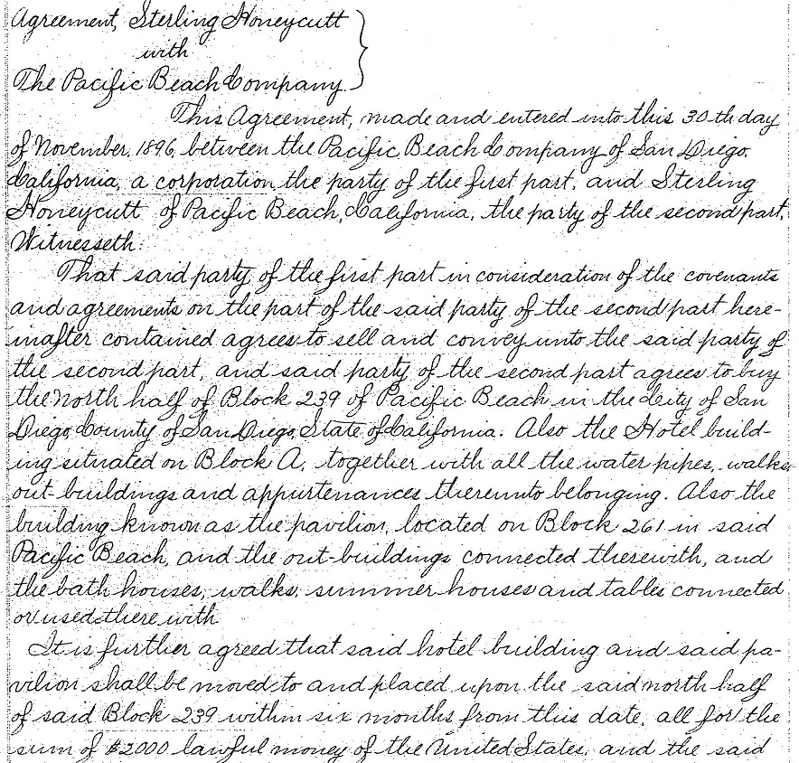
East of Fortuna Park, and within the adjoining Pueblo Lot 1799, Venice Park was subdivided in 1906 from Acre Lots 72 and 73. North of Venice Park, in Pueblo Lot 1796, Map 922 had subdivided Acre Lots 57, 58, 59 and 60 in 1904. The Venice Park and Map 922 subdivisions were divided by a street that was also called Pacific Avenue, but this section of  Pacific Avenue was separated from the Fortuna Park section by the 660-foot width of the five-acre tract. These two sections of Pacific Avenue also were not aligned with each other; the eastern portion extended 12 feet north (Map 922) and 60 feet south (Venice Park) of the pueblo lot line and the portion in the Fortuna Park additions to the west extended from 61 to 141 feet south of the pueblo lot line. In 1909 the five-acre parcel was purchased by Sterling Honeycutt and subdivided as Sterling Park, but although the map of Sterling Park referenced the sections of Pacific Avenue to the west and the east it did not set aside space for a connection between them.

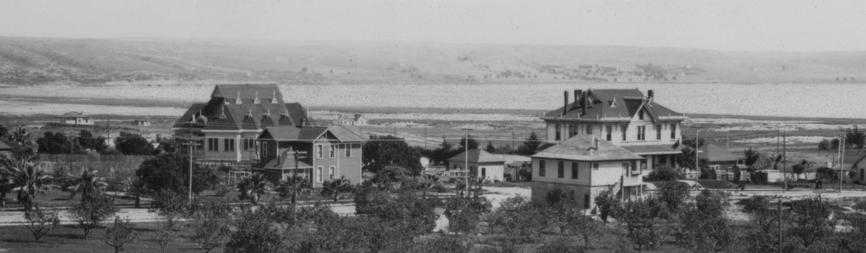
In 1899 Fred T. Scripps had purchased property in the northern portion of Pueblo Lot 1803, including Acre Lot 71, for his bayside mansion Braemar Manor. In 1903 he acquired adjoining property, including Acre Lots 69 and 70, which extended his holdings north to Reed Avenue and east to Dawes Street, and in 1907 filed a map for the Braemar subdivision. The map of Braemar included a street named Pacific Avenue, 60 feet wide, along the northern boundary of Pueblo Lot 1803. The 1925 Southern Title Guaranty Company’s Subdivision of the adjoining Pueblo Lot 1801 also included a 60-foot-wide street named Pacific Avenue along its northern boundary, which connected with the Pacific Avenue in Braemar and effectively extended the street a half-mile to the east. However, at Frontera Street (now Riviera Drive) the eastern side of the Southern Title Co. subdivision met the western side of Second Fortuna Park, where Pacific Avenue ran 61 feet south of the pueblo lot line. The 61-foot difference in the alignment of these two sections of the former Pacific Avenue explains the bend in Pacific Beach Drive at Riviera Drive today.

PacificPines

Acre Lots 61 and 62, where the Raiters had started one of the first lemon ranches in 1892, was located north of Fortuna Park and Sterling Park and separated from them by the same 61-foot strip of Pueblo Lot 1800. In 1926 these two acre lots and the 61-foot strip south of them were subdivided as Pacific Pines. The map of Pacific Pines created four blocks surrounded by Jewell and Lamont streets, Reed Avenue, and a new section of Pacific Avenue, connecting the sections west and east of Sterling Park. The Pacific Pines section of Pacific Avenue included all of the 61-foot strip south of the pueblo lot line and also, between Lamont and Kendall streets, an additional 20 feet of the former Acre Lot 61, north of the pueblo lot line. In the block between Kendall and Jewell streets, the sections of Pacific Avenue in Fortuna Park and Pacific Pines were contiguous, creating a street over 140 feet wide. The developers announced that it would be divided into two roadways with a park in the center, a configuration that exists to this day. The streets of Pacific Pines, including Pacific Avenue, were among the first in Pacific Beach to be paved, in 1927.

Harris & Wearn

When travel by automobile became possible in the first years of the twentieth century the main route between San Diego and Los Angeles and the north passed through Pacific Beach, along Garnet Avenue and Cass Street. In 1915 a bridge over the inlet to Mission Bay opened an alternate route between San Diego and Pacific Beach through Mission Beach, connecting Mission Boulevard to Cass Street via Pacific Avenue and making these two blocks of Pacific Avenue an important link in the coast highway. The route through Mission Beach, including the sections on Pacific Avenue and Cass Street, was paved in 1924.

Highway traffic continued to increase, however, and in 1930 the city opened a new route through Rose Canyon. By 1935 this new ‘gateway to the north’ had been widened, straightened and paved from downtown to the city limits at Del Mar and the city decided that it should be called Pacific Highway. To avoid confusion with the existing Pacific Avenue in Pacific Beach the city council passed an ordinance in April 1935 that changed ‘all those portions of Pacific Avenue’ (and some previously unnamed segments) to Braemar Avenue. In June 1935 the new route to the north became Pacific Highway and Braemar Avenue, formerly Pacific Avenue and originally Hubbell Avenue, was renamed Pacific Beach Drive.

Pacific Avenue

Pacific Beach, 1916

A century ago, in 1916, Pacific Beach was a sparsely populated suburb of San Diego; the 1916 San Diego City Directory listed about 150 residences in the community, including those in outlying areas like Mission Bay Park, American Park, Venice Park, Soledad Terrace and the Fortuna Park subdivisions. The community’s center, the location of offices, stores, churches, the post office, schoolhouse, etc., was the area around Lamont Street, between Grand and Garnet Avenues. It was noted as the home of San Diego Army and Navy Academy, founded in 1910 on the former campus of San Diego College of Letters and now the site of Pacific Plaza.

Pacific Beach was connected to the city by a railroad line that ran along the entire length of Grand Avenue with stations at Lamont Street and at the ocean front, where it turned north toward La Jolla. Although officially named the Los Angeles & San Diego Beach Railway, the railroad actually terminated in La Jolla and was generally known as the La Jolla line. A time card from January 1916 showed ten trains a day in each direction, four in the morning and six in the afternoon, with an extra round-trip on Saturday evenings. Pacific Beach was also connected to the city by a water main and natural gas pipeline and electric power and telephone lines.

La Jolla Railway train on right-of-way along today’s Grand Avenue near Mission Bay High School, 1914 (San Diego History Center, #91:18564-1666)

According to the January 1, 1916, San Diego Union, in its annual New Year’s Day overview of suburban communities, the situation and surrounding conditions of Pacific Beach were perfect for those who wished for a home within easy reach of the city, near the ocean and on the bay, who can have all the comforts and conveniences of the city together with the freedom of country life. Ironically, the situation and surrounding conditions changed dramatically in the first few weeks of 1916, and while residents could still enjoy the freedom of country life, the comforts and conveniences of the city, eight miles away, were temporarily out of reach.

Charles Hatfield was a self-styled rainmaker who had approached the Common Council with an offer to fill the recently completed but still mostly empty Morena Reservoir in San Diego’s backcountry for a payment of $10,000. The city accepted his offer and in early January he began releasing his secret concoction of vapors into the air above the reservoir. On January 14 it began to rain and by January 17 the rain had become a deluge, not just around Morena Dam but all over Southern California. Although Hatfield’s chemicals could never actually have influenced the weather patterns which occurred over a wide area in the following weeks, the epic floods that resulted were inevitably attributed to Hatfield’s activities (although the rains did fill Morena Reservoir, Hatfield was never paid, in part to distance the city from responsibility for damage caused by the flooding).

Among the creeks and rivers that flooded during the first week of the Hatfield storm was the San Diego River, which drained a large section of the county through Mission Valley and at that time emptied into Mission Bay. The La Jolla railroad line crossed the river on a bridge near Old Town, which also carried the water main to Pacific Beach and La Jolla. A three-year-old concrete bridge a few hundred yards upstream carried the highway from San Diego to the north via Pacific Beach and La Jolla, as well as the gas and electric lines to these suburbs. The Santa Fe railroad line to Los Angeles also crossed the river on a bridge next to the La Jolla line.

As the river rose and threatened these bridges, City Manager of Operation Lockwood had local reservoirs in Pacific Beach and La Jolla filled to their limits and then shut down the water pipeline. Although the La Jolla railway bridge was still standing on January 19, eight of its bents or pilings were reported down and the water main had broken. However, skies were clearing, the river was receding and the Santa Fe and highway bridges across the San Diego River at Old Town were believed saved. Manager Lockwood began replacing the lost pipeline to restore water service to the beach communities.

In Pacific Beach, both the railroad line and the road to the north also crossed Rose Creek and both of these bridges over this normally placid stream had also washed out. Wagon and automobile traffic to Pacific Beach was diverted to the recently completed bridge across the mouth of Mission Bay, between Ocean Beach and Mission Beach. The Evening Tribune also reported a bad washout near Fred Scripps’ place at the foot of Bayard Street. By January 22 this pond of water, which practically surrounded the Scripps home, had been drained and Manager Lockwood declared that highway traffic between San Diego and Del Mar was normal.

On January 24 another storm system arrived (Morena Reservoir had not yet filled and Hatfield was still at work) and with the rivers still high and the ground still saturated from the rains of the previous week the damage was even more severe. The highway bridge across the San Diego River at Old Town was washed away on January 27, breaking the four-inch high pressure gas supply line to Pacific Beach and La Jolla. Gangs of repair men were put to work laying pipe through Mission Beach for a temporary connection and limited gas service was available on January 28. Electric power and telephone service was also cut off and not restored for several days.

The Santa Fe railway bridge across the San Diego River had also washed away within a couple of hours of the highway bridge on January 27. The Santa Fe and La Jolla lines were essentially parallel to each other from downtown San Diego to Morena, at which point the local line turned west into Pacific Beach. With both of their bridges over the San Diego River gone, the two railroads reached a deal in which the La Jolla line lent the Santa Fe a pair of pile drivers to help rebuild the Santa Fe’s bridge and the Santa Fe agreed to allow the La Jolla line to use its tracks from San Diego to Morena over the rebuilt bridge until the La Jolla line was able to rebuild its own bridge.

A replacement for the Santa Fe bridge was ready and limited rail service to Pacific Beach and La Jolla was resumed on February 11 using the Santa Fe tracks from the downtown station to Morena. In the meantime, the Tribune reported that several young women attending high school in San Diego had been forced to take up residence in San Diego and San Diego boys attending the Army and Navy Academy in Pacific Beach could not attend school. The Santa Fe had suffered damage in several other locations along its line and it did not complete those repairs and resume operations into San Diego until a week later. The La Jolla line resumed operation over its own tracks and under its normal schedule on March 1 (the pilings which supported its rebuilt bridge over the San Diego River are still visible today). A wooden trestle replacement for the concrete highway bridge swept away in the floods opened in April. Also in April, a new 10-inch water main to Pacific Beach and La Jolla was laid across the river on the Santa Fe bridge.

OLYMPUS DIGITAL CAMERA
The San Diego River today, with pilings from the 1916 La Jolla Railway bridge in the foreground and bridges for the main rail line to Los Angeles, formerly the Santa Fe, and the San Diego trolley in the background.

While attention had been focused on restoring connections to the city, much was still going on in Pacific Beach and its environs in early 1916. A road had been built from the north end of Lamont Street to the summit of Mount Soledad and in April the Evening Tribune announced that it would be ‘dedicated, or christened, or something of that sort’ by the San Diego Floral Association, in a ceremony led by Kate Sessions. Five Torrey pines and three Mt. Diablo big cone pines, grown from seed and donated by Miss Sessions, were planted at the summit. The view from the top was said to be well worth the trip. Later, in June, the Common Council determined that the city owned the summit of Mount Soledad and voted to set it aside as a city park, but did not decide on a name. A Union columnist quipped that the city fathers were puzzled whether to call it after a former mayor or a well-known movie picture star; ‘What possible ground is there for indecision in the matter’. The council also did not provide any funds for improvements at that time. The name and status of the summit of Mount Soledad and its subsequent ‘improvement’ with a memorial cross has still not been resolved a century later.

The San Diego Army and Navy Academy, founded in 1910 with Captain Thomas A. Davis as the only instructor and an initial class of just 13 students, held its 1916 graduation exercises in June at which six students received diplomas. Opening exercises for the fall term were held on September 18 and an ad in the Evening Tribune cordially invited the public to attend; ‘The La Jolla Line car, leaving the Fourth street office at 2:15 will arrive at the Academy in time for exercises’. The ad introduced the faculty, which in addition to Davis included heads of the departments of Sciences, Mathematics and Ancient Languages, English, and Modern Languages, and a Professor of Military Science and Tactics who doubled as the Commandant of Cadets. There was also an Assistant Commandant, a Substitute in English Department, Instructor of Primary Department and a Housemother. The entire enrollment ‘up to Saturday’, totaling 62 boys, was listed by name along with their home towns.

Another important event on the academy calendar was Founder’s Day, November 23, the date the academy had been founded in 1910. The celebration in 1916 included an afternoon athletic meet and an evening banquet for students, faculty and outside friends, with Capt. Davis as toastmaster. The banquet menu (iced celery, ripe olives, pineapple salad, roast turkey with cranberries and oyster dressing, asparagus tips, drawn butter, snowed potatoes, mince and pumpkin pies) was detailed in the Tribune. Opening and graduation exercises and Founder’s Day celebrations at the academy continued to be annual events and grew in size and importance as the academy expanded over the coming decades. San Diego Army and Navy Academy failed during the depression and in 1937 became Brown Military Academy, which Davis returned to lead until his retirement in 1954. Brown Military Academy remained on the site until 1958 and many of the former academy buildings stood until 1965.

Another event which affected Pacific Beach in 1916 was the opening of an electric rail line to Mission Beach and the establishment of the Mission Beach Tent City. The Bay Shore Railroad had been incorporated in 1914 with plans to build a bridge across the inlet of Mission Bay to connect the new subdivision of Mission Beach with San Diego’s trolley system via Point Loma and Ocean Beach. The bridge had been built in 1915, and in fact had been the only route by which automobile traffic could reach Pacific Beach from the city when the highway bridge at Old Town had washed out in January. Work on the rail line began in March 1916 and by June it had been completed between Ocean Beach and Redondo Court in north Mission Beach. In north Mission Beach, work began on a Tent City, ‘a brand new, spick and span, thoroughly modern city of tents and fine bungalows; a veritable Dream City by the sea’, complete with a bath house, dressing rooms, and a shallow pool for the little folks. The developer was Josephus M. Asher, Jr., a Pacific Beach resident and local real estate operator, who agreed to develop a tent city, including streets, wooden curbs and sidewalks, a bath house, pools and a pier in exchange for title to the site. An informal opening of the Tent City and inauguration of the trolley service occurred on July 15 (final completion and a formal opening of the Tent City occurred in the summer of 1917).

In October the Union reported that United States Army ‘birdmen’ attached to the signal corps aviation school at North Island had made 5815 flights for a total time aloft of 2760 hours and a distance of about 165,000 miles so far during 1916, with only one minor mishap. Cross-country flights had been made to Pacific Beach and La Jolla, and as far away as Encinitas, and landings were made at each place. Two new 135 horsepower steel battleplanes capable of a speed of 80 miles an hour carrying a pilot and a bomb thrower were currently being assembled. The landings at Pacific Beach had been on 75 acres of land adjoining Mission Bay where the Wright-Martin Aircraft Corporation proposed establishing a testing plant and training station to facilitate delivery of aeroplanes ordered for the signal corps school. The bay would also have offered an admirable place for the teaching of seaplane students, but the proposed testing and training station was never built.

Also in October, the La Jolla railway applied to the state railway commission for permission to reduce service and increase fares. According to president E. S. Babcock the railroad had been operating at a loss for years because of the general depression and the growing number of private automobiles. This application was eventually dismissed, but it foreshadowed an application to discontinue rail service which was granted in 1919, after which the line was shut down and the rails torn up. Portions of the right-of-way between Grand Avenue and La Jolla, and the Bayshore Railroad in Mission Beach, were later incorporated into an electric rail line that ran from San Diego through Mission Beach and Pacific Beach to La Jolla between 1924 and 1940.

In 2016, meteorologists are suggesting that history may repeat itself; that ‘el niño’ conditions in the Pacific Ocean may produce storms to compare with Hatfield’s a century ago. If so, the rain will fall in a far different situation and surrounding conditions in Pacific Beach, where the comforts and conveniences of the city remain but the country life is gone forever.

Encinitas Copper Mines

Encinitas Copper

Rancho las Encinitas was granted by the Mexican governor of California to Andres Ybarra in 1842. In 1860 Ybarra sold the rancho to Joseph Mannasse and Marcus Schiller. On January 1, 1864, Mannasse and Schiller were among a group of eight San Diego notables, also including Louis Rose, who recorded claims for mining purposes located around the northeast corner of the rancho. These claims, to be called the Saint David Copper and Silver Lode, were said to be about a mile from the Mannasse home (the ruins of which are now preserved in Carlsbad’s Stagecoach Park) and was further described as about 200 feet north of the Encinitas Silver and Copper Lode, 500 feet N.E. from the ‘place worked’, following the ‘croppings’ (outcroppings?), and 1500 feet from the place worked southwesterly following the croppings.

The Encinitas lode itself was claimed a few days later by Mannasse, Schiller and Rose, along with George Haycock and Joshua Sloane, their notice indicating that the lode was near the ranch of Jos. Mannasse and had been worked a few years earlier; ‘said claim commencing at the old shaft worked in 1857 and running 1200 feet in a South Westerly direction with the croppings’. In March 1866 these individuals filed another claim for the Encinitas Mine, this time commencing at a rock in the center of the ravine and extending in a southerly direction, or in such a direction as to include the lode, for 3000 feet.

Twenty years later, in 1884, Jacob Hoke and William Dougherty filed notice of the location of two mines near the Encinitas ranch, to be known as the Iron Mountain Ledge and the Sulphuret Copper Mine. The Iron Mountain claim was said to be about half a mile from the east corner of the Encinitas ranch and running southerly 1500 feet. The Sulpheret mine ran 750 feet southeasterly and northwesterly from the mouth of a tunnel, which was located 5 chains north of the corner to Sections 32 and 33, Township 12 South, Range 3 West. These coordinates place the mouth of the tunnel a few feet south of the stream known today as Copper Creek, which runs from San Elijo Hills past the mine site and continues along Lone Jack Road to Escondido Creek in Olivenhain. The ravine at the center of Mannasse et al.’s claim for the Encinitas Mine in 1866 was also presumably Copper Creek. The tunnel noted in 1884 may well have been the same as the ‘old shaft’ near the Mannasse ranch which was worked in 1857.

Despite these indications of copper, and possibly silver and even gold, there was apparently little further interest among miners in the area around the northeast corner of the Rancho las Encinitas until the mid-1890s. In April 1896 C. A. Stockton, H. MacKinnon and C. F. Holland filed a location notice in which they claimed 1500 linear feet along the course of a lead, lode or vein of mineral-bearing quartz, and 300 feet in width along each side of the vein, together with all mineral deposits, timber and water thereon. Their claim, the Encinitas Copper Mine No. 1, extended from the center of a creek or gulch in an easterly direction and was marked with monuments at each corner. Although the location notice identified the site as situated in Township 13, Range 4 West, the actual location is in Range 3 West and extends across the line between Townships 12 and 13 South. The creek or gulch again was Copper Creek and the location appears to be the same site as the previous claims which apparently had been worked since 1857. Encinitas Copper Mines No. 2 and No. 3 were later claimed on the west side of the creek.

Location monument in former Encinitas Mining District.

Within a year of the Stockton-MacKinnon-Holland claim other would-be miners had filed claims in what they called the Encinitas Mining District. In November 1896 William Likens claimed the Encinitas No. 2 West Mine and in December L. F. Hodge claimed the Encinitas No. 2 S. W. Ext. Mine, both west of the Encinitas mine group on the west side of Copper Creek. Likens also claimed the Sentinel Mine, which followed the gulch or canyon in a southerly direction south of the Encinitas mines, and in March 1897 the Veteran Mine, north of the Encinitas mines. Andrew J. Burnett, a San Diego mining engineer, located and claimed the President, Encinitas No. 2 East and Pickett Copper mines in 1896. In December 1896 the San Diego Union reported that MacKinnon and Holland had agreed to sell to Burnett an undivided two-thirds interest in Encinitas Copper Mines No. 1, 2, and 3 for $13,330, or an entire interest for $20,000 on the condition that Burnett would sink a 50-foot shaft and 200 feet of levels (Burnett apparently did not exercise this option).

Prospecting in the vicinity continued and in August 1897 W. W. Rynearson recorded a 1500 by 600 foot quartz claim to be known as the Copper Queen. According to this location notice the Copper Queen adjoined the north line of the Encinitas Grant near the old Grant mine. Rynearson certified that $50 worth of labor had been performed developing the claim by cross cutting and sinking upon the lode or vein at the place of discovery, and in September he also located the Pacific Copper Mine, adjoining the Copper Queen along its west side.

A few days after recording these claims Rynearson sold the Copper Queen and Pacific properties to C. W. Witham and F. J. Kelly for $15,000, and the new owners apparently wasted no time developing the claims. According to the San Diego Union C. W. Witham & Co. had some twenty teams at work hauling building material from San Diego to build a dam some 60 feet high across a gulch to form a reservoir. Quite a number of loads of cement, lumber and other material for the dam were already on the grounds. The Union reported a rich strike of copper ore at the mine, said to be one of the richest discoveries of copper in the west, the assays going high and the walls of the ledge being still out of sight. A depth of twelve feet had been attained and at the bottom the ore gave indications of being very rich. ‘In the opinion of copper miners a find of this character invariably leads to a deposit of pure copper’.

However Witham, and presumably the reports of the mine’s riches, turned out to be a fraud. S. Proctor, a San Diego contractor, later said that Witham had represented himself as a wealthy capitalist and Proctor had introduced him to local businessmen as a man of unlimited credit, but when Witham and Kelly hired Proctor to build the dam at the mine site he soon found that Witham’s checks were not honored. Witham left town, skipping out on his hotel bill, and Proctor tracked him to Pasadena and had him arrested and returned to San Diego where he was jailed on the charge of evading board. He was also sued by several creditors, including Proctor and Frank H. Brooks.

Proctor had placed a lien on the Copper Queen mine to secure payment of his claims against Witham and in February 1898 the Copper Queen was ordered to be sold to satisfy the judgement (a month later, when Witham was again arrested in Pasadena on a charge of horse stealing, the Union noted that he had once been in trouble in San Diego). The Copper Queen claim was sold at public auction at the courthouse door in March 1898 and the property was ‘struck off’ to the plaintiff in the case, Frank Brooks, who submitted the highest bid at $357.77. After a year had passed and no redemption had been made the sheriff conveyed the Copper Queen to Brooks in April 1899.

Another round of locations or re-location in the Encinitas Mining District occurred at the end of 1898. R. O. Butterfield located the Gold Hill Gold and Copper Mine in November 1898 and George W. Magwood located the Copper Gulch Copper Mine in November and the San Diego Copper Mine in December 1898. Also in December 1898, Holland and MacKinnon occupied and claimed a 5 acre site among their Encinitas group of mines for a mill site. In February 1899 they located another claim, Encinitas Copper Mine No. 4, running 750 feet east and 750 feet west along the vein from near the channel of the creek about half a mile downstream from Nos. 1, 2 and 3.

In addition to making a discovery and filing a location notice, miners were required to perform annual assessment work in order to maintain their rights to a claim. Most of the claims in the Encinitas district were apparently not worth the effort but Holland and MacKinnon’s Encinitas group of mines was an exception, at least at first. C. F. Holland’s 1897 ‘affidavit of work on mining claim’ reported that a tunnel 50 feet long, 7 feet high and 4 feet wide had been run and a winze sunk in that tunnel 6 feet square by 6 feet in depth in Encinitas Copper Mine No. 1 (a winze is a vertical or inclined shaft driven downward inside a mine). A frame dwelling house had been erected, the ground graded and ditches dug for draining surface water from Encinitas Copper Mine No. 2 and for Encinitas Copper Mine No. 3 a shaft had been sunk about 4 feet, cuts run to trace the vein and a wagon road graded for transportation to and from the mine. In 1898 Holland reported that the tunnel at mine No. 1 was continued for 15 feet, at mine No. 2 pumps and pipes were replaced in the shaft, water was drained from the shaft and the drift to the north from the bottom of the shaft extended 10 feet, and at mine No. 3 a shaft was sunk 5 feet square to a depth of 7 feet.

The Encinitas copper mines attracted media attention again in September 1899 when the San Diego Union reported a rich discovery of copper, gold and silver ore in an old mine five miles inland from Encinitas. Mining men who had seen it reported that the mine was among the most valuable in the county. The mine was very old, having been opened by some of the earliest white settlers, but the ore giving these returns was entirely new in the mine and did not resemble what had heretofore been taken out nearer the surface. C. F. Holland and H. MacKinnon were the owners, and they now had about 350 feet of tunnel and shaft exposing quite a large body of ore. A new road was being graded to connect with the La Costa railroad station so ore could be sent to Denver.

Holland and MacKinnon incorporated the Encinitas Copper Mining and Smelting Company in November 1899, transferring the Encinitas No. 1, No. 2, No. 3 and No. 4 claims, four full mining claims of 1500 in length by 600 feet in width, and also the Encinitas Mill site of 5 acres to the new company. In its 1899 assessment report, the Encinitas Mining and Smelting Co., reported that the tunnel was continued another 15 feet and the shaft sunk 50 feet in the No. 1 mine and that the drift was continued at least 10 feet and the shaft timbered and hoisting works erected at the No. 2 mine. All the work was performed for the development of the same lode and for the benefit of all their mines.

The San Diego Union traditionally printed a survey of outlying areas of the county in their New Year’s Day editions. The January 1, 1900 report on Encinitas stated that the pretty little village had a neat railway depot, one general store and post office, two hotels and a school house. The population was about 50 and it was one of the most delightful summer seaside resorts on the coast. Another good thing was the opening up in the various copper claims. The Encinitas Copper Mining and Smelting Co. was working the old Encinitas mine but the Copper Queen mine was shut down and in litigation.

Later in January 1900 the Union reported that arrangements had been completed for sinking a shaft 100 feet on the prospect so that the owners would really know what they had in their hole in the ground. In February, MacKinnon and Holland located Encinitas Copper Mine No. 5, north of and adjacent to mine No. 1 and re-located Encinitas Copper Mine No. 3, north of and adjacent to mine No. 2. In March the report was that the hole was down 94 feet and the way that the quality of the ore had been increasing led the projectors to believe that they had a bonanza. The ledge had widened from a trace at the surface to 6 feet at the present depth and there was every indication that it would grow wider. The last assay was nearly 14% copper. At the end of 1900, Frank P. Frary, secretary of the Encinitas Mining and Smelting Co. certified that at least $2000 worth of labor and improvements had been performed on the Encinitas group of mines, known as Encinitas claims Nos. 1, 2, 3, 4 and 5, consisting of sinking shafts, furnishing materials, powder and fuse, repairing road, deepening a spring on No. 4 and building houses.

In 1900 a new mining company, the Danes Lea Mining Co., appeared on the scene in the Encinitas Mining District. In March 1900, Wilfred C. Harland, the president, filed notices locating the Danes Lea copper mines No. 1 and 2 in the Encinitas district. Later in the year the Danes Lea company also acquired the Copper Queen, Copper Chief, Red Coat, Blue Boy, Red Star and Copper Prince claims. During 1901 the Danes Lea company also bought about 40 acres at the NE corner of the Rancho las Encinitas subdivision, adjacent to the mining district (the former rancho had been subdivided in 1894) and in December 1901 acquired two additional claims from the Encinitas mining company.

News from the Encinitas Mining District had described the location and trading of claims, the development of mines and speculation about the value of the ore, but little or no news about actual production from the mines. In February 1902 the San Diego Union did report that the Danes Lea mine had 2000 tons of copper ore ready for the local smelter as soon as it began to operate and in May the Union reported that Clarence Cole was hauling a carload of ore from the Danes Lea copper mine to Encinitas for shipment to the smelter.

Huntington centrifugal mill reduced crushed rock to fine particles for further processing.

In August 1903 the Evening Tribune reported that the Encinitas Copper Co. had ordered an 80-ton Huntington concentrator. The concentrates would be shipped to San Diego where they would be smelted. There were several hundred tons of ore on the dump but no attempt had yet been made at reduction. Pending arrival of the machinery, roads were being built and other preparations made for doing business on a wholesale plan. The January 1, 1904, Union reported that development work on the ledges of copper-bearing ore at Encinitas had been started a few days earlier by the Encinitas Copper Mining and Smelting Co. which had just erected a mill for concentrating the ore. The mill had a capacity of about 60 tons a day and consisted of a crusher, Huntington mill, concentrating tables, engines and necessary fixings. There were about 1000 tons of ore on the dump running from 1% to 15% copper and an almost unlimited supply in the ground.

Mount for Huntington mill, foundation for concentrator and tailings at Encinitas copper mine site.
Mount for Huntington mill, foundation for concentrating tables and tailings at Encinitas copper mine site.

The smelter in San Diego was never completed, however, and the cost of transporting the copper concentrate to more distant smelters made continued operations at the Encinitas mines unsustainable. Still, there was occasional news from the Encinitas Mining District over the next few years. In May 1905, the Tribune noted encouraging reports of renewed activity from the Encinitas camp. Sinking would be commenced in the main shaft within a short time and other development work pushed. The company had been developing the project for several years and has spent considerable money. One road which wound through the hills to the railroad cost $3500. One shaft had been sunk to 200 feet where the vein was about 14 feet wide. In October 1907 the Union reported that the Encinitas copper mines were to be taken over and worked by R. J. Coleman, formerly associated with great mining properties in Utah and Mexico with the intention of extensively developing the properties at Encinitas. The mill would be enlarged and all necessary facilities would be provided for economical working.

The New Year’s Day 1908 edition of the San Diego Union included a survey of mining in San Diego County. A section on copper claimed that some unusually extensive copper deposits had been found in the county. The ore was of a high grade and had been discovered in sufficient commercial quantities to justify working. Several years ago a large amount of development was done on the Encinitas copper mines but for some reason work was abandoned and no attempt was made to mine the ore. Recently experienced mining men secured control of the property and work was being done with the view of opening up the mines. Mining men were enthusiastic over the prospects in the Encinitas district, the camp was taking on a new life, and some extensive development could be expected. Both gold and copper could be mined at a profit.

In 1916 D. C. Collier led two automobile loads of mining and money men on a tour of a number of sections between Encinitas and Escondido (Collier was a lawyer and real estate promoter sometimes credited as the creative genius behind San Diego’s Panama-California Exposition of 1915). The mining men brought fine samples of copper ore taken from the neighborhood of the Encinitas mine where the shaft was down to 425 feet and the ore was said to promise good returns. The Ernsting Company’s jewelry store had an interesting display of copper ore taken from a mine operated by the Encinitas Copper Mine Co. The samples showed rich ore and the company expected to be operating a mill in 60 days.

Despite these occasional upbeat reports in the local papers, copper mining in the Encinitas district was ultimately unsuccessful and the Encinitas mines are now almost entirely forgotten (except for a street in a nearby residential neighborhood named Copper Crest Drive). In 1981 Richard Bumann included a photo and a brief mention of the mines in his history of Colony Olivenhain. According to Bumann, the mines consisted of three vertical shafts, two horizontal shafts and a small processing mill. About 5,000 pounds of copper was produced in 1905 but the mines then closed (at about 12 cents a pound in 1905, that amount of copper would have been worth about $600). When World War I caused the price of copper to rise to 27 cents a pound the mines were reopened and about 7,000 pounds were produced between 1915 and 1917 (worth about $1900). An attempt to reactivate the mines in 1925 failed and they have since been blasted shut.

Copper tailings on Denk Mountain.

Today most of the area once considered the Encinitas Mining District is still undeveloped and some is preserved within the Rancho La Costa Habitat Conservation Area, open space set aside by developers as mitigation for impacts to natural habitat in their developments. Evidence of mining activity including tailings and location monuments can still be seen on the southwestern slopes of Denk Mountain. At the site of the main mine and mill on Copper Creek there are more tailings and other ruins, including the foundations of the Huntington mill and concentrator. The 1500 by 600-foot claims of the former Encinitas Copper Mines Nos. 1, 2, 3, and 5 at this site are still designated as mining lots on county parcel maps.

MiningLots

Pacific Beach Hotel

The Pacific Beach Hotel was built in 1888 at the foot of Grand Avenue, a location near the beach and the terminus of the railroad from San Diego. Along with a nearby dance pavilion it was expected to be one of the main attractions of the new suburb. In 1897 it was moved from its original location to what had since become the center of the community, Lamont and Hornblend streets, and for another quarter century served first as a hotel then as the offices of the succession of real estate companies that hoped to benefit from the community’s growth. When it burned down in 1931 it had been vacant for years and was considered a haunted house by local residents.

The heart of Pacific Beach from Wheeler's map. The 'Avenues' south of Grand Avenue are named for early PB land speculators including Thomas, Reed, Gassen and Hubbell (Thomas and Reed Streets survive to this day). This map also shows Missouri Avenue (Street), the only surviving 'state' street name in the PB grid.

In 1887 a ‘syndicate of millionaires’ acquired most of the property in the undeveloped area north of Mission Bay (then called False Bay), christened their new tract Pacific Beach, and incorporated themselves as the Pacific Beach Company. These developers also built a railroad line that ran from downtown to the ocean front in Pacific Beach over what are now Garnet, Balboa and Grand avenues. At about where Second (now Bayard) Street intersects Grand the railroad line curved south to a passenger depot and maintenance facility at the end of the line. In 1888 the Pacific Beach Company built a hotel, the Hotel del Pacific, on Block A along this curve, the site of the present-day Starbucks on the southeast corner of Grand and Mission (2022 note; Starbucks has been replaced by Presotea).

News from Pacific Beach during the late 1880s and early 1890s suggested that the hotel was not initially a success. In November 1889 a Special Notice in the San Diego Union, ‘Removed to 872 Sixth St. The remnant of furniture from Pacific Beach Hotel, cheap’, implied a clearance sale. By September 1890 the hotel had apparently dropped the Hotel del Pacific name and was under new management; the Union ran an ad for ‘Pacific Beach Hotel, new management–reasonable rates. Choice rooms, with lovely ocean view; excellent meals. Special rates made to parties and families. Picnics supplied on short notice. Magnificent beach; fine surf bathing; bath house in connection; free use of pavilion. Round trip by motor from San Diego, 25 cents. For rates and further information address Pacific Beach Hotel, San Diego, Cal. Telephone 198’.

There may also have been difficulties with vendors or contractors; the Union’s Local Intelligence column in March 1891 reported that the argument to set aside the order for sheriff’s sale in the case of the Southern California Lumber Company vs. the Pacific Beach Hotel was continued before Judge Torrance (a sheriff’s sale was a public auction of real property at the courthouse door to satisfy a judgement against the property owner). Not all of the news was discouraging, though; the Union reported in February 1892 that the Pacific Beach Hotel was full. In February 1893 the Pacific Beach railway advertised Sunday excursions to Pacific Beach for 25 cents, round trip. Luncheon could be had at the Pacific Beach Hotel for 25 cents.

In 1894 the Pacific Beach railway was extended to La Jolla, which had its own hotel among other attractions, and the added competition may have diminished the appeal of the Pacific Beach Hotel. In October 1894 the Pacific Beach Notes column in the Union noted that the Robertsons had moved into the hotel building, wording which suggested an extended stay and a possible change in the hotel’s purpose (Thomas Robertson was an engineer for the Pacific Beach Railway; he was killed, ‘literally cooked alive’, in a 1908 train wreck). A state committee considering sites for a normal school in February 1895 was offered the former San Diego College of Letters buildings and its 16 acres of land in Pacific Beach and also the Pacific Beach Hotel and pavilion.

By December 1896 the hotel had apparently become such a liability that the Pacific Beach Company reached an agreement with Sterling Honeycutt to take it off their hands. The company granted Honeycutt the north half of Block 239 of Pacific Beach and required him to move the hotel building situated in Block A and the building known as the pavilion located on Block 261 to this new location within six months. The new property, the south side of Hornblend between Lamont and Morrell streets, was over a mile inland and near the College railway stop at Lamont and Grand Avenue. The price was $2000.

hotel

The move was completed within the allotted time with the hotel building placed upon the northwest corner of the block, the southeast corner of Lamont and Hornblend, and the pavilion on the northeast corner of the block, the southwest corner of Hornblend and Morrell. The San Diego Union reported in February 1897 that three carpenters and several masons and plasterers were working on the Hotel del Pacific, and it would soon be ready for the painters (the old name was still faintly visible on the porch roof in photos taken at the new site). It was apparently ready for business by the end of the year and ads appeared in the Union in October 1897 for ‘Business Chances; the Pacific Beach Hotel, 20 rooms, with all heavy furniture, to rent on reasonable terms. Address S. Honeycutt, Pacific Beach, Cal’. In November the Union reported that Mr. Honeycutt had rented the hotel to a Mr. Hurd. Another series of ads then announced that the Pacific Beach Hotel was open for guests; ‘large sunny rooms, most pleasant dining room in the county. Everything new, and best of attention shown to our guests’.

However, even in its new location the Pacific Beach Hotel was apparently not a very good ‘business chance’. It was listed in the Union again in May 1898: ‘For rent—The Pacific Beach Hotel, modern building containing fifteen rooms completely furnished; one of the nicest seaside hotels near San Diego; motor railroad stops in front of the hotel. A good chance for a nice family. References required’. In July 1899 Pacific Beach Notes in the Union noted that the hotel had been opened by Messr. Gregg and their mother, Mrs. Greenwood, arrangements with Mr. Rowen not being consummated. For his part, Mr. Honeycutt granted an undivided half of his interests in Block 239, ‘including the building known as the Pacific Beach Hotel and furniture’, to Mrs. Honeycutt in 1899.

Business did improve when a Y.M.C.A Summer Camp was held at the college in August 1899 and the hotel and college buildings were filled with summer school students. Business also apparently picked up in the winter; in February 1900 Pacific Beach Notes noted that the hotel was full of visitors from the East and in September 1900 many eastern people were said to have engaged rooms for the coming winter.

In November 1903 the San Diego Union reported that a big Pacific Beach hotel building formerly owned by Sterling Honeycutt has been sold to purchasers represented by Folsom Bros., the well-known real estate men, who would not say who the purchasers were but promised big improvements. The purchasers turned out to be the Folsom brothers themselves and the improvements may not have been that extensive; a month later the news was that the new hotel owned by Folsom Bros. was expected to be opened to the public before the expiration of the present week. Mrs. M. I. King, well known in San Diego as a first class hotel manager, would be in charge. The Pacific Beach Hotel did open and was listed in the 1904 and 1905 San Diego City Directory, with Mrs. M. I. King as manager.

However, Folsom Bros. Co. still felt the need for a modern, attractive and at the same time reasonably priced resort hotel to accommodate their clients from the north and east. In 1904 they leased and a year later completed the purchase of the campus and buildings of the former San Diego College of Letters, a block northwest of the Pacific Beach Hotel on the north side of Garnet. Folsom Bros. Secretary O. W. Cotton explained to the Union in 1906 that the company then remodeled and rebuilt these buildings from top to bottom, named the place Hotel Balboa, and had one of the most delightful year around hotels on the coast, which was rapidly becoming one of the most popular.

With a modern, attractive, delightful and popular hotel only a block away Folsom Bros. Co. had no need for a second hotel in the vicinity and instead took over the former hotel building for their offices. When Lamont Street was graded in 1907, the Union reported that work on curbs and sidewalks would commence in a few weeks, starting at the railway depot at Lamont and Grand and continuing up Lamont past the general offices of the Folsom Bros. Co. and to Hotel Balboa.

The Folsom brothers retired from active management of Folsom Bros. Co. in 1910 and in 1911 the company was renamed the San Diego Beach Company, which San Diego City Directories listed at ‘Lamont cor Hornblend’ and later at 4437 Lamont, Pacific Beach. San Diego Beach Company notices for stockholders meetings and assessment (and delinquent) notices for stockholders posted in the Evening Tribune listed the company’s address as 4437 Lamont as late as 1921. After the San Diego Beach Company moved its office downtown later in 1921 the building was apparently abandoned, although in 1928 the Evening Tribune carried a story about an Easter outing given by the Dixie Riding Academy of Pacific Beach, 4437 Lamont Street.

Magner White, then a reporter for the San Diego Sun, had received the 1924 Pulitzer Prize for a story about an eclipse of the sun. In 1930, writing for the Evening Tribune, White wrote about a ‘foray’ into an old deserted dwelling at Pacific Beach: ‘A house vacant more than two years immediately becomes a “haunted” house—and in Pacific Beach, on Lamont avenue, there’s one, a 20-room, high-windowed, high-ceilinged frame structure, that has been vacant more than five times two years.’ It had once been a hotel but ‘aloof and deserted and weed-bordered’ it had since been gathering the traditions of a “haunted” house; children wouldn’t go into it, mysterious lights were seen in upper rooms, doors slammed mysteriously and broken panes rattled and sometimes fell out. Nevertheless, accompanied by two squealing, giggling little girls, his party decided to investigate.

There was a health department notice on the front door warning that the place was unfit for human habitation until brought up to date with plumbing (although there wasn’t any sign of plumbing, even in the kitchen). There were long half-inch pipes hanging from the ceiling which curled up to end in spigot-like fixtures, plainly gas pipes indicating that the place had once been lighted with gas. Old letters and other papers dating back more than 20 years were scattered over one of the floors, including O. W. Cotton’s June 1907 pay stub from Folsom Bros. Co. (for $150). They paused at the top landing and an old door chose that moment to fall off its hinges. White admitted that he jumped, and the little girls squealed. In the attic they found the source of the mysterious lights; candles discarded by hoboes who had been sleeping there. There were also old cans and more than two dozen empty whiskey bottles. When they opened the door to one room that probably had been closed for months if not years a jar of canned fruit in the room exploded, possibly due to the sudden admission of fresh air. The little girls ran back downstairs and the rest of them decided it was time to get out.

White had noted that a story such as this always brought out the facts and that within a few days someone was bound to write in, and indeed a few days later he reported that M. W. Folsom had written him with some interesting facts. The huge “haunted house” frame building in Pacific Beach was the building known at first as the Pacific Beach Hotel and that was later used as the general offices of his company, Folsom Bros. Co. Except for the Hotel Coronado, it was San Diego’s first beach-front hotel, built at the end of Grand Avenue, and later moved to its present site.

A little over a year after Magner White’s story, on December 3, 1931, the San Diego Union reported that fire of unknown origin had destroyed the Old Pacific Beach Hotel building, corner of Lamont and Hornblend streets, Pacific Beach. The fire was discovered at 10:30 the previous night and firemen were still fighting the blaze in the morning. The hotel, a historic landmark in Pacific Beach, was built more than 40 years ago. It was three stories high, had been vacant for several years, and was last occupied by the local telephone company. More than 35 cadets from the San Diego Army and Navy Academy had arrived at the scene of the blaze first and had prevented the flames from spreading to nearby buildings. They used a fire hose from the academy and made connection to the street hydrant (the Academy had been founded in 1910 in the former Hotel Balboa buildings). The next day the Union reported that the fire marshal believed that the fire was incendiary, based on two previous attempts set fire to the structure on June 21, but that this belief had not been substantiated by evidence. The building was admittedly a fire trap.

OLYMPUS DIGITAL CAMERA

The site of the former hotel, real estate office and haunted house is now occupied by the Patio on Lamont Street restaurant. Ornate bike racks have replaced the paved walkways which once led from the curb to the entrance doors facing Lamont. The towering palm trees along Lamont Street that were planted nearly a century ago in front of the Folsom Bros. Co. office are all that remain today of this historic Pacific Beach landmark.

OLYMPUS DIGITAL CAMERA


PB Methodist Churches

The first church in Pacific Beach was organized in September 1888, the year after the community’s creation and opening sale of lots. The founder was Rev. C. S. Sprecher, who was also one of the founders of the San Diego College of Letters which opened the same month on the College Campus, now the site of Pacific Plaza. In 1889 the church acquired property across the street from the college and a year later a building was moved onto the site for church services. The Pacific Beach Presbyterian Church is still there, at the southwest corner of Garnet Avenue and Jewell Street, although the original wooden church gave way to the current mission-style building in 1941.

The college failed in 1891 but Pacific Beach found a new purpose as a center of lemon cultivation. Many of the lemon ranchers, however, were not Presbyterians and in 1901 a Methodist congregation was also established in Pacific Beach. At first the Methodists met at the Presbyterian church but in 1904 they purchased ten lots at the southeast corner of Lamont and Emerald streets and modified the existing building on the site for their own church building (in 1906, the Methodist minister, Henry Roissy, also purchased the former home of E. C. and Rose Hartwick Thorpe on the other side of Emerald Street, the northeast corner of Lamont and Emerald).

In the first years of the twentieth century the lemon industry also declined but real estate speculation, led by Folsom Bros. Co., generated new growth in the population, and in church congregations. The San Diego Union reported in April 1906 that Easter services in both Pacific Beach churches were well attended, especially the Methodist chapel; ‘Mr. Roissy being very much liked and an able speaker, the chapel will soon have to be enlarged’.

Fundraising for a new Methodist church included what the Union called a good, old-fashioned, healthy (for body, soul and pocket-book) box social held in the church parlor. ‘To the uninitiated-and there were many-the excitement of buying at auction, suppers, in dainty boxes; hunting the fair partners who had prepared them; then examining and partaking of the delicious feasts, was wholly enjoyable’ (attendance was good, in spite of inclement weather, and the treasurer was able to add $10 to the steadily growing church fund). If box socials were already old-fashioned in 1906, the custom may require explanation today. Young ladies would bring a dinner for two in an elaborately decorated box to the box social, where the boxes were auctioned off to the young men in attendance. When all the boxes had been claimed, the young men would discover which of the young ladies had prepared their box, then sit down to enjoy the contents with her. The proceeds of the auction would go to the church. The boxes were supposed to be anonymous, but it wasn’t unheard of for the girl who donated one to provide a favored boy with a hint.

Instead of enlarging their existing church building, the Methodists acquired one of the largest buildings in town and remodeled it. This building had originally been built in 1888 as a dance pavilion overlooking the beach near the foot of Grand Avenue and close to the terminus of the railway between San Diego and Pacific Beach. In 1896 lemon rancher Sterling Honeycutt had purchased the north half of Block 239, the south side of Hornblend Street between Lamont and Morrell streets, and moved the dance pavilion (and the hotel which had adjoined it) to this property, which was across Lamont from his lemon ranch. At its new location on the southwest corner of Hornblend and Morrell the former dance pavilion was also on the railway line to San Diego and Honeycutt had converted it into a lemon curing and packing plant. By 1906, however, the lemon business in Pacific Beach had also run its course, and Honeycutt, a founder and trustee of the Methodist Church in Pacific Beach, donated the packing house to the church. $2,500 in repairs was required to transform the building into the ‘beautiful church edifice’ that was dedicated in February 1907.

(SDHC #395-A)
The Pacific Beach Methodist Church (former dance pavilion, left) and Folsom Bros. Co. office, (former hotel, right), on Hornblend Street between Lamont and Morrell, dominate the PB skyline in 1908. Lamont Street is in foreground. (San Diego History Center #395-A)

In 1912 the old church property at Lamont and Emerald was sold to Bessie Davis, wife of San Diego Army and Navy Academy founder Capt. Thomas A. Davis. The Davises built a home on the property, which was just across Lamont Street from the academy, and spent the rest of their lives there. The Roissys sold the former Thorpe home to John L. Davis, Jr., Capt. Davis’ brother, in 1924 and ‘Mother’ Davis, their mother, lived there into the 1950s. That house burned down in 1957.

The Methodists continued to worship in the church at Hornblend and Morrell until 1922 when it was sold and apparently torn down. It had disappeared from the tax rolls by 1924 and for the next 25 years Methodists in Pacific Beach had to attend services elsewhere. As the population surged in the 1940s a new Pacific Beach Methodist Church was established in 1947, led by Rev. Alfred Hughes. This congregation met in a church building built for the Wee Kirk by-the-Sea in 1943 at the southeast corner of Emerald and Haines streets.

Wee Kirk by the Sea

A few months after re-establishment of the Methodist church at Emerald and Haines, the San Diego school district announced an ‘exchange of functions’ between the Pacific Beach Elementary School, then located on the north side of Emerald Street, across from the church, and the Pacific Beach Junior High School, then located where PB Elementary is now, at Fanuel and Tourmaline streets. The junior high school would occupy the site of the elementary school, which would be expanded to accommodate its expected growth. The school superintendent was authorized to acquire the two blocks of property south of the school, which included the Methodist church.

In May 1948 the school board offered the Methodist church $36,000 for the property and Rev. Hughes accepted (he also paid $5050 for a house and garage that the school auctioned off after acquiring another parcel in the expansion area, in what is now right field of the recreation center softball diamond). Rev. Hughes’ and most of the other buildings on the new school property were moved or cleared away before the school reopened in time for the 1950 school year. However, many former students of the junior high school (now PB Middle School) remember the church building still standing in the middle of their school playing fields into the 1960s.

A month after selling the former Wee Kirk by-the-Sea building to the school district, the Methodists dedicated a site at the southwest corner of Ingraham and Thomas streets for a new church. Former barracks buildings from Camp Callan in Torrey Pines were moved to the site and served as church buildings until a new sanctuary was built in 1959. This sanctuary and the former barracks (now known as Hughes Hall) remain the home of the second oldest church congregation in Pacific Beach.

San Diego Beach

Pacific Beach. What could be a more fitting name for a district of San Diego with a wide sandy beach along the Pacific Ocean? That is apparently what the original promoters of Pacific Beach thought in 1887 when they christened their new subdivision and incorporated themselves as the Pacific Beach Company. And that is what this community of San Diego is still called today. But in the 1920s a new developer, declaring that the past had not done justice to San Diego’s finest residential area, decided that it needed a fresh start, beginning with a new name: San Diego Beach.

It was true that Pacific Beach had been a disappointment to the succession of real estate operators who had come before. The Pacific Beach Company had donated a four-block campus near the center of their tract (where Pacific Plaza is today) and had expected a college built on the site, the San Diego College of Letters, to attract purchasers for their town lots. However, the college failed within a few years and the hoped-for college town reverted to a semi-rural community dependent on lemon ranching. In 1903 Folsom Bros. Co. acquired much of this property as well as property in the Crown Point area that became the Fortuna Park additions. Folsom Bros.’ plan was to stimulate growth through a program of improvements, which included grading streets, laying curbs and sidewalks, and renovating and reopening the former college buildings as the Hotel Balboa. However, these improvements also failed to attract a sufficient number of new residents and in 1910 the Folsom brothers withdrew from their company, which was then taken over by A. H. Frost and renamed the San Diego Beach Company.

By the early 1920s there were about 150 residences and 500 residents in Pacific Beach. Most community activity was still centered within a few blocks of the former college campus, which had been reborn once again in 1910 as the San Diego Army and Navy Academy (later Brown Military Academy). One of the two churches was across the street from the academy, at the corner of Jewell and Garnet. The Pacific Beach schoolhouse was next door to the church on Garnet, although it was replaced in 1923 by a new school a block further west at Emerald and Ingraham, now the site of the PB middle school (the old wooden schoolhouse was moved onto the academy grounds to serve as its junior school). The Women’s Club building was a block south of the academy, on Hornblend between Jewell and Kendall streets. The office of the San Diego Beach Company and the other church (before it was sold in 1922) were also on Hornblend, between Lamont and Morrell streets (these buildings had originally been a hotel and a dance pavilion on the beach at the foot of Grand Avenue and were moved to this more central location in 1897). The post office and a store were at the corner of Lamont and Grand, another block south.

However, the steam railroad between San Diego and La Jolla, which had run along Grand Avenue in Pacific Beach and stopped at a station at Lamont and Grand, had been abandoned in 1919. The electric rapid transit line from San Diego to La Jolla which replaced it in 1924 followed a different route, over a bridge at the entrance to Mission Bay and along Mission Boulevard through Mission Beach and Pacific Beach. The more developed central portion of Pacific Beach had become more isolated and the undeveloped beach-front areas more accessible.

The main coast highway connecting San Diego to Los Angeles and the north, paved in 1919, then ran through Pacific Beach along Garnet to Cass, north on Cass to Turquoise Street and west on Turquoise to Bird Rock and La Jolla. An alternative route between San Diego and Pacific Beach via Mission Beach also joined the coast highway at Garnet and Cass. In 1923 Earl Taylor, a real estate operator recently relocated from Long Beach, noted that over 6000 autos daily, including about 70 auto stages, representing over 25,000 people, passed this intersection of the main artery to the beach and the coast highway each day. In October 1923 Taylor acquired more than 100 lots west of Cass Street, most of them facing Garnet Avenue, and in March 1924 he announced construction of the new business center of Pacific Beach, or New Pacific Beach, which he styled ‘the coming Long Beach of San Diego’ (apparently a positive image in that era). Improvements in New Pacific Beach included the Dunaway Pharmacy building, completed in 1926, which is still standing at the corner of Garnet and Cass.

Taylor also invited successful developers from beach-front communities around Los Angeles to invest in New Pacific Beach, and in 1925 Ernest Pickering, who had developed the pleasure piers in Santa Monica and Venice, announced plans for a million-dollar pleasure pier in Pacific Beach (a pleasure pier was basically an amusement park built out over the beach; although definite amusements were not announced, the Evening Tribune speculated that they would likely include Ginger Snaps, Great Slides, Over-the-Tops, Treat-em-Roughs, and other devices dear to the pleasure-loving world at Southern California beaches). Taylor expected the pier to increase prosperity for Pacific Beach, noting that lots in Venice were valued at up to $1000 a front foot following construction of their pier. In fact, the Union reported, Venice had been built and sustained by the amusement pier industry.

Although Pickering was the ‘Pleasure Pier King’ and the project was initially referred to as the Pickering Pier, he soon backed out and turned over development of the pier to Neil Nettleship, a prominent Santa Monica realtor. Nettleship was also put in charge of the development of over 500 acres of Pacific Beach property that the pier syndicate had acquired from the San Diego Beach Company. It was Nettleship, said to be moving with his family to Pacific Beach for permanent residence, who decided that Pacific Beach needed an entirely new identity.

Declaring that the good people of the section formerly known as Pacific Beach had expressed themselves overwhelmingly in favor of a change of name to San Diego Beach, and a charter had been secured from the Secretary of State for the San Diego Beach Chamber of Commerce, Nettleship ‘took the liberty’ of dedicating a full-page ad in the October 4, 1925, San Diego Union to ‘enumeration of the reasons for the aforesaid change of names’. First, he said, Pacific Beach might describe anywhere on the Pacific coast, and he claimed there was, in fact, a Pacific Beach near Los Angeles (there actually is another Pacific Beach in Washington). San Diego Beach could only be in one place. Second, San Diego Beach definitely identified San Diego as being on the sea, a fact which he claimed most Americans were not aware of, and naming a beach after it would advertise this fact to the world. Third, ‘new occasions teach new duties’, so the new Pacific Beach would benefit immeasurably by a fresh name and a fresh start in life. The past had not done justice to its purple, panoramic hills, its inimitable mountain-marine views, its graceful, unobstructable slopes, its tall, commanding palisades and its gentle, sea-level sites. ‘A new name, O Pacific Beach! A new fame, O San Diego Beach!’

An accompanying article in the Union declared that the future of newly named San Diego Beach, formerly Pacific, was assured. The greatest factor in the rapid rise of San Diego Beach was said to be the new fast San Diego Electric car service; San Diego Beach realty experts declared that without this service former Pacific Beach languished, with it San Diego Beach should increase at least 1000 per cent in population within the next 12 months or two years at the outside. Nettleship was quoted as saying that the new name had superior advertising value, both to San Diego and to the former Pacific Beach and that ‘All in all, the change should be highly beneficial to all concerned, the small loss in sentiment being many times compensated for in the greater clarity, vigor and import of the new name’.

To capitalize on the superior advertising value of the new name, the first official act of the new San Diego Beach Chamber of Commerce was the creation of an 80-foot streamer to be stretched across the intersection of Garnet Avenue and Cass Street, the new ‘business center’ of the ‘new beach’. The Union initially reported that the streamer would read ‘San Diego Beach combines the features of all beaches – beauty, climate, bathing, soil, accessibility’. However, the Nettleship Company (‘acting in the general good of the new San Diego Beach, nee Pacific Beach’) changed course and announced that the slogan would be selected in a word-‘less’ contest (‘in which you would be rewarded for the number of words you leave out – the shorter the slogan, the more paid’). In creating a slogan it would help to bear in mind that San Diego Beach combined the features of all beaches – ‘five-point’ perfection; the climate of Long Beach, the beauty of Santa Monica, the soil of Santa Barbara, the swimming of Palm Beach and the accessibility of Venice; ‘It has what other beaches want’. Presumably bearing this in mind, Mr. S. A. Smith of La Jolla received $20, $2.50 a word, for the winning slogan: ‘San Diego Beach has what other beaches want’.

Despite the greater clarity, vigor and import, and the superior advertising value of San Diego Beach, the community had been called Pacific Beach for nearly 40 years and transitioning to a new name was bound to be awkward. Some followed the Nettleship Company in treating Pacific Beach like a maiden name; a December 1925 ad for Beach Property contained a listing for a good, substantial 5-room plastered house on Grand Avenue in New San Diego Beach (Nee Pacific Beach). Other writers inserted ‘Pacific’ parenthetically into the new name, as in a June 1926 full-page ad in the Union by the Greater San Diego Beach Association inviting potential investors to ‘Live – Play and Profit at San Diego (Pacific) Beach’. A May 1926 story in the Evening Tribune about an upcoming grunion run on San Diego beaches included an invitation to ‘smelters’ from Neil Nettleship, prominent developer of San Diego (Pacific) Beach, to make use of the free and public beach oven (fire ring?), fire-wood pile, picnic tables and other conveniences provided on the beach adjoining the site of the new pier.

On other occasions, the two names, or even combinations of the two names, were mixed. Nettleship himself announced in April 1926 that an estimated 10,000 people attended the formal christening of the new pier in Pacific Beach as ‘Crystal Pier’ (despite threatening weather and actual showers). He then went on to say that the future of San Diego’s Pacific Beach was assured, and that he regarded San Diego Beach, in fact, as the perfect beach, possessing all five of the requirements which make it so (this time he went on to note which requirements the competition lacked; Long Beach lacked panoramic beauty, Santa Barbara lacked accessibility to a large population, Santa Monica lacked perfect swimming, Venice lacked fertile soil and Palm Beach lacked the perfect climate). Newspaper reports also mixed the two names, sometimes in the same article. In May 1926 the Union reported that a plan by ‘resort boosters’ to put the road up Mt. Soledad in shape for automobiles and eventually pave the ‘short-cut from Pacific Beach to La Jolla’ was put forward by the chambers of commerce of Mission Beach, San Diego Beach and La Jolla

In at least one instance, local governments implicitly endorsed the name change. In December 1925 the Common Council of the City of San Diego and the Board of Supervisors of the County of San Diego signed off on Kendrick’s Addition to San Diego Beach, a subdivision of Acre Lot 47 Pacific Beach. This term remains part of the legal description of property on Chalcedony and Missouri streets between Ingraham and Jewell to this day.

The annual roundup of regional attraction on New Year’s Day, 1929, included a story about long stretches of clean white sand that were playgrounds for thousands annually. Pacific Beach was said to be on high, sloping land overlooking the ocean and affording a marvelous panorama to the south. ‘Marking a new era of development Pacific Beach has recently been rechristened San Diego Beach, and much activity has centered during the past year there, and in its immediate vicinity’ (despite PB’s rechristening, the article then moved on to La Jolla, ‘just north of Pacific Beach’).

Despite the promotional campaign by local realtors and occasional mention in the papers, the name San Diego Beach did not catch on and was rarely used outside of real estate ads. In city directories of the late 1920s, for example, even the entry for the Nettleship-Tye Company, ‘Developers of San Diego Beach’, listed its branch office at the Crystal Pier Bldg, Pacific Beach. The new name also failed to produce the population growth that Nettleship had predicted and the real estate market in Pacific Beach, or San Diego Beach, continued to languish. The branch office in Pacific Beach was closed by 1930, the Nettleship-Tye Company itself had disappeared by 1931 and in 1932 Neil Nettleship was managing a life insurance office downtown. Neil Nettleship’s idea that the real estate market would somehow benefit from a fresh name and a fresh start was no more successful than those of his predecessors and as he withdrew from Pacific Beach and eventually from the real estate business San Diego Beach went with him.

Haskins Hospitality

OLYMPUS DIGITAL CAMERA

James H. Haskins was a master machinist and inventor who was awarded his first patent, a screw-cutting tool for metal lathes, while still in his early 20s. He later worked for the McCormick Harvesting Machine Company in Chicago. According to the San Diego Union, he was for many years superintendent of the McCormick reaper factory there. While at McCormick he received several more patents for machines that improved the manufacture of components for the company’s harvesters. In 1902 McCormick merged with four smaller rivals to become the International Harvester Company. At about that same time Haskins, then in his early 50s, retired, and with his wife Frances, relocated to San Diego.

In June 1904 he purchased the southeast corner of Acre Lot 78 in Pacific Beach from O. J. Stough. Acre Lot 78 was between today’s Diamond, Haines, Chalcedony and Ingraham streets, and Haskins’ property extended 125 north and 250 feet west from the corner of Diamond and Ingraham. Stough owned the balance of Acre Lot 78 as well as the adjacent Acre Lot 79 ½, between Diamond, Gresham, Chalcedony and Haines, and in 1905 Stough and Haskins recorded a subdivision map which divided these acre lots back into the four residential blocks originally platted in the 1887 map of Pacific Beach. Haskins’ property became lots 21 – 30 of Block 146 according to Map 948, Subdivision of Acre Lots 78 and 79 ½ at Pacific Beach. Map 948 also restored Missouri Street and the alleys that had appeared on the original 1887 map.

In September 1905 the Evening Tribune reported that a building permit had been issued to J. H. Haskins for a residence at Pacific Beach to cost $5000. In November, the Union reported that Mr. and Mrs. Jas. H. Haskins had spent part of the week superintending the erection of their new home, and a week later announced that the magnificent home at Diamond and Broadway was fast nearing completion (actually, Broadway had been renamed Izard Street in 1900; it became Broadway once again in 1907 and was finally renamed Ingraham in 1913). Workmen were putting the finishing touches on the garage in the rear. The residence was a credit not only to Pacific Beach but to all San Diego and was constructed partly of the concrete blocks manufactured by Folsom Bros. Co. and the rest entirely of redwood.

Once in their new home the Haskins quickly established a reputation for hospitality that was often featured in the local papers. In March 1906 the San Diego Union reported that Mr. and Mrs. Haskins of Diamond Street had entertained a small company with whist and fireside tales. Bright lights streaming from the many windows assured the guests, long before reaching the home, the cheery welcome waiting there. The games seemed hardly begun when the charming hostess led all in to a delicious luncheon. Later they were shown through the cottage – a thoroughly modern and typically American suburban home – and it was with regret that they dispersed at a late hour. On another occasion, Mr. Haskins’ birthday in January 1907, his wife gave him a surprise, ‘a party with a cake and candles and all the goodies and pleasures that go to make up such an event’. The Union reported that at first a few friends ‘happened’ in to play cards, but before long quite a merry company had assembled to enjoy their host’s surprise, and Mrs. Haskin’s hospitality.

However, the most popular gatherings were when Mrs. Haskins opened her beautiful home for her annual reception to the members of the Pacific Beach Reading Club. These events apparently began at a regular meeting of the Reading Club in January 1908 at the Haskins’ home. According to the San Diego Union, after the study session and musical numbers, including a piano solo by Mrs. Cotton, Mrs. Haskins transformed the social hour into a reception for the members and their many guests, ‘ushering in the new year with good company and a good welcome’. The color scheme was green and red, an abundance of smilax, carnations and roses supplied from her own beautiful grounds and arranged with the assistance of Mr. Haskins. ‘The dining room table was radiant with its snowy napery, red ribbons and carnations and a variety of the cakes for which the hostess is famous’. Other members (members of the Reading Club were all women) assisted in receiving and presided at the tea table, the chocolate table and the punch bowl, assisted by a coterie of young ladies. After another round of musical entertainment featuring local women and girls in songs, solos, duets and chorus, ‘the appreciative audience demanded many recalls and Mrs. O. W. Cotton continued to give rare pleasure to the departing guests to the very last’.

Mrs. Haskins hosted the Reading Club again in December 1908 and, according to the Union, members and their friends responded in the number of a hundred and over, having learned in the past that no greater treat was in store for them in the season of good cheer. The hostess was assisted in receiving by Mesdames Howard, Norris, Robinson and Pease, all handsomely gowned and showing the Christmas spirit of good will to all. Mrs. Haskins opened the musical part of the program with a classical selection on the gramophone, followed by piano solos and vocal duets by some of the guests. ‘The house is finely contrived for an assembly, and seems a silent partner in the wholesouled, far-reaching hospitality of its owners . . . The viands, in unlimited quantity, were the best in variety and toothsomeness that this notable housekeeper could produce.’

The wholesouled hospitality and toothsome viands continued to be offered for many more years. In April 1915, for example, the Evening Tribune reported that the ladies’ aid society auxiliary of the Methodist Church had been invited to the Haskins’ delightful home to be entertained with instrumental and vocal music. About 50 guests were present, and after the program a delicious luncheon was served with Mr. and Mrs. Haskins’ usual well-known hospitality. Several gentlemen with carriages and autos kindly carried the ladies to and from the entertainment. The Haskins home had a garage (which workmen had been putting the finishing touches on in 1905) and Mr. Haskins owned an automobile (in 1912 a party of San Diego friends was taken in Mr. Haskins’ automobile to his beach home) so one of the gentlemen kindly carrying the ladies in an auto may have been Mr. Haskins himself.

In 1908 James Haskins was elected by the San Diego Common Council to fill a vacancy left by the resignation of the incumbent from the first ward. The San Diego Union noted that he had been a resident of Pacific Beach for the past two years and was looked upon as one of the most prominent citizens and the one best fitted to represent that section of the city. Haskins ran for a full term as city councilman in the general election of March 1909 but was defeated. He was also one of the organizers of the Pacific Beach Country Club, which held a Washington’s Birthday dance at the Hotel Balboa for its initial meeting in 1909 (the other organizers were A. F. MacFarland, G. H. Robinson and A. R. Pease).

A 1915 Union article about Pacific Beach noted that several of the county’s showplaces were within its environs, notably the homes of Fred T. Scripps, James H. Haskins and Charles C. Norris (the Scripps home was on Mission Bay, where the Catamaran Hotel is now; the Norris home is still standing on Collingwood Drive). In 1908 the Haskins had also built another house, valued at $3600, on the portion of their property to the west of their home. They also owned property in Block 145, on the other side of Ingraham Street, and in Block 162, across Diamond Street, about where the locker rooms at the PB middle school are today. They sold the property with the house next door in 1920 and both of the unimproved properties in 1925.

Mr. Haskins died in April 1930 and Mrs. Haskins died a month later. In their will they left the ‘Home Place’, together with all furniture, fixtures and fittings, to their neighbor S. A. Le Fevre (the ‘residue’ of the estate, about $10,000, went to Haskins’ brother, Robert G. Haskins, of Pontiac, MI). Le Fevre lived a block away, at the northwest corner of Diamond and Jewell (originally the home of the Cogswell family) but at the time there were no other houses between them on Diamond Street. He apparently left the Haskins home vacant until December 1937 when it was sold to Florabel and Ralph Skinner, and it has been owned by the Skinner family ever since.

Mr. Skinner was a teacher at La Jolla High School who also became a prominent citizen in Pacific Beach, at one time serving as president of the PB Chamber of Commerce. The Skinners also became prominent in the sports world; Florabel and Ralph’s son Bob went on to become a major-league baseball player and manager and Bob’s son Joel also played baseball in the major leagues. S. A. Le Fevre received notoriety of a different sort; he had lived alone as a pauper in his Diamond Street home but when he died in 1940 he was found to have $8000 in two bank accounts, and a search of his house turned up a roll of bills worth $2000 under a pile of clothing in a closet.

North Shore Highlands

OLYMPUS DIGITAL CAMERA

The Mexican Pueblo of San Diego covered the territory between National City and Del Mar west of the line of Interstate 805 (the land east of 805 had belonged to Mission San Diego). When San Diego became an American city in 1846 it assumed ownership of these pueblo lands and they were surveyed and platted into pueblo lots, typically a half-mile square and 160 acres. Some of these pueblo lots were sold to individuals; in 1867 Alonzo Horton famously bought six pueblo lots on which he established Horton’s Addition, now the heart of downtown San Diego. The city also offered pueblo lands as inducements to companies that proposed to end San Diego’s isolation by building railroads to the east. These lands were intended not only for the actual rights-of-way and for stations and shops, but also as subsidies to be used by the railroad companies as they saw fit.

The offer of thousands of acres of pueblo lands to the San Diego and Gila Southern Pacific and Atlantic in 1854 and the Texas and Pacific in 1873 did not result in any actual rail-building. In 1880 the city tried again, offering the land it was able to recover from the Texas and Pacific to the Atchison, Topeka and Santa Fe Railroad. Among the pueblo lots offered as subsidies were several in the area that would become Pacific Beach, including Pueblo Lot 1791, a half-mile square centered around today’s Gresham and Chalcedony Streets, and Pueblo Lot 1795, centered around Jewell Street and Grand Avenue. A subsidiary of the Santa Fe, the California Southern Railroad, did actually initiate construction of a railway which eventually connected to the Santa Fe and the east. When this railway met its initial construction milestones, in 1882, the property, including Pueblo Lots 1791 and 1795, was deeded to its real estate subsidiary, the San Diego Land and Town Company.

When the Pacific Beach Company was formed in 1887 it acquired Pueblo Lot 1795 from the Land and Town Company and the area within its boundaries became the central portion of the new Pacific Beach subdivision, including most of the College Campus (now Pacific Plaza). However, the Pacific Beach Company did not acquire the adjoining Pueblo Lot 1791, and it was left conspicuously blank in the first recorded subdivision map, Map 697, in 1892.

Map 697, Recorded January 1892

In 1893 the Pacific Beach Company did buy most of the eastern half of the pueblo lot and it was incorporated into the Pacific Beach subdivision in Map 791, recorded in 1894.

Map 791, recorded December 1894
Map 791, Recorded December 1894

The remaining portion of Pueblo Lot 1791, the west half and the north three-quarters of the north half of the north-east quarter (i.e., the west half and the north 3/16 of the east half), or about 95 of the original 160 acres, was acquired by Abel H. Frost in 1896 for $3500.

Frost arrived in San Diego in 1896 from Michigan, where he had been in the lumber business. In San Diego he joined forces with a niece and nephew and incorporated the A. H. Frost Company to manage his growing real estate empire. Frost also became a director and eventually president of the Folsom Bros. Co., which owned most of the property in Pacific Beach at the time, and when the Folsom brothers retired in 1910 he renamed it the San Diego Beach Company. While his San Diego Beach Company actively developed and promoted its properties in Pacific Beach, his A. H. Frost Company did nothing to promote the Frost tract in Pueblo Lot 1791, and it remained undeveloped for over 25 years (although about two acres at the eastern edge, that portion east of a northerly projection of Ingraham Street, was split off and included with other Frost property in the Congress Heights Addition, between Ingraham, Loring, Kendall and Beryl Streets, in 1914).

In 1923 the A. H. Frost Company sold the property in Pueblo Lot 1791 to the Southern Trust and Commerce Bank, and the portion south of Diamond Street was included in a new Congress Heights No. 2 subdivision. In 1925, the Southern Trust and Commerce Bank transferred both the original Congress Heights and Congress Heights No. 2 subdivisions (minus the few lots already sold) and the remaining undeveloped portion of the Frost tract north of Diamond to the Union Trust Company. This undeveloped portion, from Everts to Gresham between Diamond to Beryl Streets and from Everts to a northerly projection of Ingraham Street between Beryl and Loring, was subdivided in 1926 as North Shore Highlands. Actually, the boundary of Pueblo Lot 1791 lies about 75 feet west of Everts Street, so the row of lots along the west side of Everts is also within the North Shore Highlands subdivision. East of Foothill Boulevard, the western portion of Monmouth Drive and the area south of the Loring Street hill are also included in the subdivision.

When the first unit of North Shore Highlands went on sale in December 1926, the announcement in the San Diego Union highlighted the fact that A. H. Frost had held the property intact for 25 years, ‘refusing to have it spoiled by marketing it at the wrong time or cut up’, and as a result it was a ‘choice, highly improved property in the heart of fast-growing San Diego Beach, without a clutter of old homes on it’. The ‘beautiful sea-view district’ had an ‘inimitable panoramic view’, illustrated by a panoramic photo showing Pacific Beach, Crown Point and Mission Bay, apparently from the top of Loring Street hill (despite the fact that only a few lots were located in the foothills and most were on the coastal plain with little if any view). An ad offered this ‘choicest, most scenic residential property’ for only $940 to $1250, but warned that these present low opening prices would soon be a thing of the past.

The announcement of the opening sale also described a $200,000 improvement program to begin at once, consisting of paved streets, sidewalks and curbs, gas, water, electricity, sewers, ornamental lights and other features. Within a few months the Common Council of the city of San Diego passed a resolution of intention to grade and pave the streets with a Portland cement concrete pavement, and to construct cement sidewalks, curbs, culverts and sewer mains, cast iron water mains and an ornamental lighting system. The lighting system was to consist of reinforced concrete lighting posts, globes, refractors, lamps, and pot heads, along with cables and other appurtenances. The improvements were to be paid for by serial bonds, to be repaid at 7 percent interest by charges upon an improvement district which included all the property lying within North Shore Highlands.

By mid-1927 the promised improvements were well under way, according to George M. Hawley in the Evening Tribune. The Hawley organization had taken an exclusive contract for the promotion and sale of the North Shore Highlands tract and their July 23 ad in the Tribune followed a familiar script when they invited the public to a good luncheon and concert at their big tent at Diamond and Fanuel Streets, but also added a contemporary flourish; free airplane trips over the north shore district in a Ryan monoplane, ‘same type as carried Lindbergh over the Atlantic’ (Charles Lindbergh’s famous solo flight from New York to Paris in the ‘Spirit of St. Louis’, a San Diego-built Ryan monoplane, had occurred two months earlier, in May 1927).

The promoters of North Shore Highlands had envisioned a ‘new high-class residential subdivision’ with large lots and ‘race and building restrictions that would make it highly desirable’. The lots were large; the standard lot was 50 feet wide rather than the 25-foot width of most lots in Pacific Beach, and lots in the foothills area and on the strip along the west side of Everts Street were even larger. Race restrictions meant that the lot could never become the property of, or even be occupied by, ‘any person other than of the Caucasian race’ (unless they were a servant or employee of a Caucasian occupant). Among the building restrictions were requirements that the property could only be used for a single, private, residential purpose, the residence erected on the premises would be limited to one story and could not cost less than $4000, no common shingled roofs would be permitted, and no pepper, eucalyptus or cypress trees could ever be planted (black acacia could be planted, but only between the cement walk and the curb).

While the promoters proclaimed that these restrictions made North Shore Highlands highly desirable, and the introduction of the San Diego Electric Railway line to La Jolla via Mission Beach and Pacific Beach in 1924 had improved access to San Diego, potential purchasers were apparently not impressed; of the more than 300 lots in the subdivision only six had been purchased, and only three residences built, by 1930 (and the owner of one of these lots and residences was one of the promoters).

In addition to high purchase prices and the added costs of the building restrictions, purchasers of property in an improvement district like North Shore Highlands were required to pay an annual assessment to service the improvement bonds, and under the Mattoon Act of 1925 would also be responsible for a share of the assessments of any residents of the district who defaulted (two lots in North Shore Highlands were foreclosed and offered for sale by the city for non-payment of the improvement bond). The negative effect that the great depression of the 1930s had on the real estate market must have also impacted sales. Only ten residences could be counted in an aerial photo from 1935, after the tract had been on sale for more than eight years, and the 1937 San Diego city directory listed only ten addresses on its streets.

The completion of the causeway across Mission Bay to Crown Point in 1931 further reduced travel time to San Diego, the Mattoon Act was repealed in 1933 and the economy began recovering from the great depression in the mid-1930s. In 1937 a new promotional campaign by E. G. Anderson Co., developers of Crown Point, announced the ‘opening’ of North Shore Highlands, ‘prices from $500 . . . all improvements in and paid for . . . no bonds, no assessments’. The E. G. Anderson company also offered to build a ‘distinctive dwelling’ on a purchaser’s lot. Lot sales in North Shore Highlands began to respond; in the 1200 and 1300 blocks of Missouri Street the number of homes listed in the San Diego city directory increased from 1 in 1937 to 3 in 1938, 6 in 1939 and 8 in 1940.

The Consolidated Aircraft Corporation had relocated to San Diego in 1935 and in 1940, in anticipation of World War II, greatly expanded its San Diego manufacturing facilities to produce thousands of B-24 Liberator bombers. Tens of thousands of new workers migrated to San Diego to staff the factories, and all these new aircraft workers needed a place to live. The federal government responded to the acute housing shortage by building entire communities of temporary housing, including the Los Altos Terrace housing project just across Loring Street from North Shore Highlands. Commercial real estate developers followed suit by building inexpensive ‘standard built’ homes in existing housing tracts like North Shore Highlands.

Model standard-built homes in the 1300 block of Missouri today.
The original model standard built homes in the 1300 block of Missouri today.

Newspaper ads in 1941 invited the public to inspect standard built homes by Convers and Donahoe in the 1300 blocks of Missouri, Chalcedony and Law streets; ‘we have not tried to create something new but have incorporated in the floor plan the last word in conservative living. Ten homes completed or under construction’. The ad for Little Castles, Inc., reported continuous and increasing demand for well built homes in the Highlands of beautiful Pacific Beach; ‘Two-bedroom homes ranging from $3295 to $3895, turn-key job – no extras. A minimum down payment, balance like rent. Offices at 1311 Chalcedony St’.

Sales of standard built homes within North Shore Highlands exploded; the San Diego city directory showed that the number of homes in the 1200 and 1300 blocks of Missouri Street increased from 8 in 1940 to 28 in 1942. The comparable blocks on Chalcedony and Law streets each had one home in 1940 but there were 21 homes on Chalcedony and 16 on Law in 1942 (7 of these 65 homes were listed as vacant in 1942, presumably completed but not yet sold). By 1945 the number of homes on these streets had grown to 30, 24 and 22, well over half of the 40 lots on each street, and none were vacant. Similar growth occurred throughout the subdivision, at least outside of the foothills area where the steep terrain made construction of inexpensive homes impractical, and by 1950 these areas had been built out. And with zoning regulations still favoring single-family residences many of these standard built homes from the 1940s are still standing.

North Shore Highlands has a unique history and followed a separate development path from the rest of Pacific Beach, but what really sets it apart from the surrounding neighborhoods today are the ornamental street lights which still line the streets and even extend along Fanuel Street to Garnet Avenue and along Loring Street to Cass Street (at the time the lights were installed the highway between San Diego and Los Angeles ran through Pacific Beach along Garnet and Cass; Fanuel and Loring would have been the main access routes to this highway). Although the lights have been removed from Foothill Boulevard they can still be seen all the way up Loring Street hill and on Monmouth Drive. Ironically, while the ornamental street lights were installed in the 1920s to mark North Shore Highlands as a high-class residential community, they were not actually turned on until 1944, when the community had been largely settled by ordinary people in ‘standard built’ homes.

OLYMPUS DIGITAL CAMERA

Original 1887 PB Map

The San Diego History Center library in Balboa Park is a rich source of historical information, not only original documents from the early days of San Diego and a huge collection of historical photographs but also a knowledgeable staff. One day I asked their map expert if she knew about a map of the Cloverdale subdivision by H. K. Wheeler from the 1880s. She didn’t, but a few minutes later she returned and said that H. K. Wheeler had ‘rung a bell’ and would I be interested in another map by H. K. Wheeler, this one of the Pacific Beach subdivision from 1887. What she showed me was a large (18 X 20-inch) photocopy of a much larger (9 X 10-foot) map which she said was rolled up and stored on top of a shelf in the storage area behind her desk. I had seen early maps of the Pacific Beach subdivision, including the map that was generally considered the original PB subdivision map (Map 697, recorded in January, 1892), but this map was significantly different and seemed like it could be a kind of ‘missing link’ in Pacific Beach history.

Wheeler PB Map 5
Central portion of 1887 subdivision map of Pacific Beach by H. K. Wheeler. (SDHC #1669)

The most striking feature of the 1887 Wheeler map is how similar it is to what Pacific Beach has become in the intervening century. The entire area from the ocean to about Rose Creek and from the tips of Mission Beach and Crown Point to the Mt. Soledad foothills was divided into a grid of city blocks by north-south ‘streets’ and east-west ‘avenues’, most of which exist today and some of which have even kept their original names (Grand, Thomas and Reed Avenues). There was even a four-block area in the center of the community that was then set aside for a College Campus and which today is the Pacific Plaza shopping center. There were over 400 city blocks, most of them in the same location as they are today and many with the same block numbers.

In the 1887 Wheeler map the north-south streets were numbered, from First Street (nearest the ocean) to Seventeenth Street (near Rose Creek), with a somewhat wider street named Broadway (now Ingraham) between Eighth and Ninth. The east-west avenues included the much wider Grand Avenue, which was also to be the right-of-way for a railway to San Diego. Avenues north of Grand were named for states, except for College (now Garnet) Avenue, which ran by the College Campus. South of Grand the avenues were named for officials of the Pacific Beach Company and other local real estate operators; Thomas, Reed, Gassen, Hubbell, Hensley, Platt, Metcalf, Hale, Collins and Poiser.

In the 1892 map, however, the grid of city blocks was limited to a central slice of Pacific Beach, between Reed Avenue and Alabama Avenue (now Diamond Street). The streets and avenues in this area were the same as on the original 1887 map, and with the same names, but the newer map reclassified most of the area between today’s Diamond and Loring Streets, and between Reed Avenue and what became Pacific Beach Drive, as rural ‘acre lots’ of about 10 acres. Most of the streets did not continue into these rural areas and many of avenues that had appeared on the original map in these areas had been eliminated. Most of the area north of Loring and south of PB Drive was no longer included on the map at all. The 1892 map retained about 125 of the original 400-plus city blocks platted in the 1887 map, while adding about 75 new acre lots.

Map 697, Recorded January 1892

The Spring 1976 issue of the Journal of San Diego History contained a paper by Zelma Bays Locker titled Whatever Happened to Izard Street? Pacific Beach and its Street Names. From 1954 to 1967 Mrs. Locker had been the librarian in charge of the downtown San Diego Library’s California Room, a repository of local and regional historical archives, and after her retirement from the library she served as a director of the San Diego Historical Society, which became the San Diego History Center. She also lived on Yarmouth Court in Mission Beach, on the ‘outskirts’ of Pacific Beach, so she was well qualified to write an academic article on Pacific Beach history.

Mrs. Locker’s article was primarily about the street names that exist in Pacific Beach today, particularly the alphabetical series of north-south streets (Bayard, Cass, Dawes, etc.; Allison Street, the first in the series, has since been renamed Mission Boulevard). In 1900 the city of San Diego decided that all street names had to be unique, and since there were many other communities of San Diego with numbered streets or streets named for states, those in Pacific Beach would have to be renamed. She was unable to find any historical record of how the streets were renamed and her own research led her to conclude that the only underlying theme for these names was that they were all statesmen who would have been familiar to the public in 1900 (even though some of the names were misspelled, e.g., Everts Street was apparently named for William Evarts and Fanuel for Peter Fanueil). The street between Haines and Jewell, originally Broadway, was renamed Izard Street in 1900 after a revolutionary war patriot, but the phonetics of this name did not ‘set well’ with residents and eventually it was changed to Ingraham.

Grand Avenue and the avenues named for Thomas and Reed were apparently unique within the city in 1900 and were not renamed, but the avenues on the 1892 map north of Grand were renamed, again in an alphabetical sequence, for gemstones or minerals, from Agate to Hornblend (again with misspellings; Felspar Street for Feldspar and Hornblend for Hornblende). When the ‘acreage country’ north of Diamond was re-subdivided again in the early 1900s, restoring the avenues that had existed on the original 1887 map between what had become Agate, Beryl, Chalcedony and Diamond, these ‘new’ avenues could not be incorporated into the alphabetical gemstone sequence. Some, like Turquoise, Tourmaline and Sapphire were named for gemstones anyway, but out of sequence. Mrs. Locker could not account for the names of others, such as Law, Wilbur and Loring, or for Missouri Street, which she called a ‘real puzzler’. She wrote that it was not on the ‘original 1887 map’ and was first named in Hauser’s Subdivision in 1904 (actually it had been named in F. T. Scripps’ Ocean Front subdivision in 1903). She added that there had been a Missouri Street in University Heights since 1888 but that it was now 32nd Street.

Missouri Street was a puzzler for Mrs. Locker because she was unaware of the actual original 1887 subdivision map by H. K. Wheeler, the ‘missing link’ in PB’s historical record. She wrote in her article that the first subdivision map of Pacific Beach was platted and the land put on the market in October 1887 by the Pacific Beach Company, but curiously enough, the original map was not filed with the County Recorder until January 2, 1892, a fact which would have a later bearing on some street names. Actually, the first subdivision map was platted in October 1887 (although lots were not put on the market until December) but the map that was filed on January 2, 1892, Map 697, was not the original but an amended map of a smaller and more rural subdivision. The original 1887 map did include a Missouri Avenue, between Alabama and Idaho Avenue (now Chalcedony Street). Missouri Avenue was deleted from the 1892 map to make way for a row of acre lots, including Acre Lot 49, between Alabama and Idaho. John and Julia Hauser purchased Acre Lot 49 in 1903 and in 1904 they filed a plat of Hauser’s Subdivision of Acre Lot 49 which basically returned it to the configuration on the original 1887 map; two city blocks separated by a street named Missouri (apparently, the Missouri Street in University Heights had already been renamed and no longer represented a conflict at that point).

Map of Hauser's Subdivision
Map of Hauser’s Subdivision

Although it may be true that the 1887 Wheeler map itself was never recorded, over a hundred deeds to Pacific Beach property were recorded prior to 1892 and some of these deeds include legal descriptions which could only have been derived from the original Wheeler map. For example, Matilda O’Neil was granted a deed in April 1888 for Block 295, between Gassen and Hubbell Avenues. Gassen and Hubbell Avenues appeared on the original Wheeler map but neither were still listed on the 1892 map. F. W. Barnes bought lots 21-28 of Block 166 in March 1889; Block 166 was shown on the original Wheeler map but not on the 1892 revision where it had been incorporated into Acre Lot 64 (Barnes then bought all of Acre Lot 64 in 1892). Other deeds from this period include specific references to the ‘official map of Pacific Beach, made by H. K. Wheeler, 1887’, or similar terms. On the other hand, no acre lots were sold prior to 1892. Acre lots did not exist on the original subdivision map and first appeared on the revised Map 697. Thirteen acre lots were sold in just a few months after Map 697 was recorded.

The 18 X 20-inch black-and-white copy of the original 1887 Pacific Beach subdivision map by H. K. Wheeler at the History Center had markings on it which suggested that the original had been used to keep track of or to display the extent of lot sales. The map was extremely detailed; each of the city blocks showed the individual lots on that block and some of these lots were ‘marked out’, presumably indicating that they had been sold and were no longer available (some of the ‘marked-out’ lots were also apparently pasted over, perhaps indicating that the sale had fallen through and they were again available). The marked-out lots generally corresponded to lots for which deeds had been recorded in the County Recorder’s office.

Eventually, the History Center library staff let me see the original map; they lifted it down from its shelf and laid it out on one of tables in the library. The map was in two halves, each of them five feet wide and nine feet long and rolled up together. When unrolled each completely covered one of the large library tables. At this scale each city block was over 1 ½ inch wide and nearly 3 ½ inches long. Within the blocks, what had appeared to be black markings on the black-and-white copy turned out to be either red or blue, with red predominating in the west half and blue in the east half. According to library protocol I wasn’t allowed to photograph the map, but I was able to write down most of the block numbers with red or blue marks and later found that the blue lots generally matched lots endowed by the Pacific Beach Company to the San Diego College Company, to be sold by the college to raise funds for operations (these lots didn’t sell well and the college closed after a few years). The red lots matched lots purchased by private buyers. There actually were small pieces of paper pasted over a few of the lots, apparently to ‘erase’ the markings beneath them if a sale fell through.

The History Center card catalog entry for the photocopy (M1669) indicates that the original map was stored in the archives but not cataloged because of its ‘unmanageable’ size, and that the photocopy was supplied in 1987 by Mr. John Fry of Pacific Beach, who obtained permission to make the copy (John Fry is the long-time president of the Pacific Beach Historical Society). When I asked John about the map he could only recall trucking something up to Kearny Mesa where they put it on a wall and took a picture of it, so the provenance of the map and its accession to the History Center in Balboa Park remains a mystery. A photo in the center’s photo collection of the Pacific Beach Company’s downtown office in 1888 includes a large map of Pacific Beach, but the details of that map do not match the 1887 Wheeler map.

Outside the Pacific Beach Company office, 1888.
Outside the Pacific Beach Company office, 1888. (SDHC #3797)

One thing that does seem certain is that Zelma Bays Locker, despite her years at the California Room and the Historical Society, never saw the actual original 1887 Pacific Beach subdivision map by H. K. Wheeler.

A Distinguished Address

OLYMPUS DIGITAL CAMERA

The quaint cottage at 2104 Diamond Street, overlooking the corner of Diamond and Noyes, is one of the first houses ever built in the Pacific Beach subdivision and may be the oldest one still standing. It is also associated with some of PB’s most distinguished early-day residents.

In 1887, at the height of San Diego’s great boom, a ‘syndicate of millionaires’ bought up the property we now know as Pacific Beach, incorporated as the Pacific Beach Company and, in October 1887, filed a map for the Pacific Beach subdivision. In December 1887 they held an opening sale which the San Diego Union called the most successful in the history of San Diego real estate transactions, with over $200,000 worth of lots ‘disposed of’. Not only that but the paper reported that the buyers were all legitimate investors, many of them intended to improve their lots and five handsome residences were to be erected immediately.

For some reason, perhaps because the lots were sold on an installment basis, the first deeds were not actually recorded until April 1888, but one of the first deeds that was recorded, on May 18, 1888, was for lots 39 and 40 of Block 140, the property under what is now 2104 Diamond Street (on the 1887 map it was Alabama Avenue, at the corner of Thirteenth Street). The grantee was Madge Morris Wagner and the consideration was $250 gold coin of the United States of America.

Madge Morris Wagner was the wife of Harr Wagner, editor of the Golden Era, a literary magazine established in San Francisco in 1852. Wagner had purchased the Golden Era in 1882 and in 1887 he moved it to San Diego, explaining to his subscribers that San Diego was destined to become a great city and the Golden Era was determined to contribute to and benefit from the city’s growth. In a May 1887 editorial he explained the benefits to a city of an institution of higher learning and suggested that San Diego was large enough to support one. To implement this vision, Wagner convinced the Pacific Beach Company to include a college in the plans for their new community. The October 1887 subdivision map did set aside a four-block College Campus in the center of town, where Pacific Plaza is now, and the Pacific Beach company deeded it to the college company founded by Wagner and his partners, C. S. Sprecher and F. P. Davidson. The cornerstone for the San Diego College of Letters was laid in January 1888 and the original college building was completed and opened for 37 students in September 1888.

San Diego College of Letters and student body, Pacific Beach, 1888.
San Diego College of Letters with student body, faculty and staff, Pacific Beach, 1888 (San Diego History Center #9800).

As a founder and professor at the college Harr Wagner would have been one of the first residents of Pacific Beach, and the house built on the Wagners’ property at the corner of Alabama and Thirteenth, a short walk from the college, may have been one of the handsome residences expected to be erected immediately, possibly as early as 1888. Although they had lived at 2229 E Street downtown when the 1887-88 San Diego City Directory was printed, their residence was listed as Pacific Beach in the 1889-90 directory.

From 1888 to 1892 John D. Hoff’s Asbestos Company was located near the present-day intersection of Garnet Avenue and Soledad Mountain Road in Pacific Beach. Hoff’s asbestos works manufactured paints, boiler coatings and other products incorporating asbestos. A March 1889 ad in the San Diego Union listed some well-known persons having Hoff’s asbestos goods in use and one of these well-known persons was Harr Wagner. Although the ad doesn’t specify what goods were in use or where they were being used, several of the other references on this list were located in Pacific Beach, including the College of Letters and the Presbyterian Church. It may be that Harr Wagner had used Hoff’s asbestos paint to protect and fire-proof his house, just a few blocks down the street from Hoff’s factory, sometime before March 1889.

There was certainly something there by the end of 1889. A U. S. Coast and Geodetic Survey map of the Pacific Coast from False Bay to La Jolla, dated 1889, covered Pacific Beach and included cultural features such as buildings and roads. One of the buildings that showed up on this map was at Alabama and Thirteenth, presumably the Wagners’ home. The map also shows two buildings labeled ‘University Buildings’ a few blocks to the west. The original college building had been built in 1888 but a second building, Stough Hall, was begun in September 1889 and completed in January 1890. On the map, the western-most of the two university buildings is in the appropriate location for Stough Hall, but in the wrong orientation, aligned with the original college building. Stough Hall was actually aligned with College (now Garnet) Avenue and at an angle to the original building. Apparently the cultural features on the map, which included the house at Alabama and Thirteenth, had been field-checked in late 1889 when the location of Stough Hall was apparent but its final footprint was not.

1889Map

Madge Morris Wagner was a successful writer in her own right who had long contributed articles and poems to the Golden Era. In 1889 she began work on a novel, A Titled Plebian, which was completed in July 1890 and published in the December 1890 issue of the Golden Era. An ad for Hoff’s asbestos company in the same issue of the Golden Era said that the author had written the narrative at her Villa Home, Pacific Beach – made attractive and beautiful – both interior and exterior – by Hoff’s Glossy Asbestos Paints. ‘The Mirror Walls through her open casement windows reflect on the shores of the Bay – a net-work of buildings – alive with busy men Amalgamating, Packing and Shipping Hoff’s Asbestos Paints and Lubricants’. The house at 2104 Diamond, on a bank above the street, still has a view of the shores of Mission Bay that would have included the site of the asbestos works, alive with busy men in 1889 and 1890.

The development of Pacific Beach and the establishment there of the San Diego College of Letters had anticipated that the population growth seen during San Diego’s great boom would continue indefinitely. Unfortunately for the developers, and for the college, the boom suddenly ended in 1888, a few months after the Pacific Beach Company’s opening sale and before the college had even opened. In addition to the grant of the College Campus itself, the company’s endowment to the college had included hundreds of lots to be sold by the college to fund future operations. The end of the boom, however, caused a collapse in the San Diego real estate market, including Pacific Beach lots, drying up this expected source of funding. The college managed to stay open for two years but in the summer of 1890 Harr Wagner and his fellow founders, Sprecher and Davidson, transferred their interest in the college company to ‘eastern parties’, presumably with deeper pockets. Wagner and Sprecher resigned their positions on the faculty to devote their time to the Golden Era, where Wagner was Editor and Sprecher became Associate Editor. Davidson remained at the college to represent the new owners.

In November 1890 Harr Wagner was elected County Superintendent of Schools and Madge Morris Wagner took over as editor of Golden Era. Wagner’s tenure as superintendent was notable for his progressive educational policies, but he was defeated for reelection in 1894 and eventually decided to take the Golden Era back to San Francisco.

In October 1891 the San Diego Union reported that Harr Wagner had moved his household goods from his home in Pacific Beach to the corner of Walnut and Albatross, and that Mr. Havice had moved into the house vacated by Mr. Wagner (George Havice was married to Harr Wagner’s sister Jennie). The Havices also owned an entire block, Block 213, a few blocks to the south, between what are now Garnet Avenue and Noyes, Hornblend and Morrell Streets. In 1892 the San Diego Union reported that Havice had set out lemon trees on his property, introducing the lemon industry that was to revive the economy of Pacific Beach and sustain it over the next decade.

Although the Wagners had moved to the Bankers Hill area, they still owned the property in Pacific Beach where in 1893 city records listed improvements assessed at $240, presumably the value of the house at the corner of Alabama and Thirteenth. In 1894 the Wagners sold the property to Elizabeth Dunn of Columbus, Ohio, and from 1895 to 1904 city records listed it under her name, with improvements continuing to be assessed in the range of $175 to $200. Miss Dunn, however, remained in Ohio and the property, and the house, has always been associated more with her sister, Dr. Martha Dunn Corey, a Pacific Beach pioneer who was also the region’s first resident physician.

In 1892 the Pacific Beach Company had begun selling ‘acre lots’ in the outlying areas of the community, tracts of about 10 acres intended for agricultural development. One of the first acre lots to be sold, in February 1892, was Acre Lot 19, granted to Lucien Burpee in trust for Martha Dunn Corey and her children (Acre Lot 19 is now C. M. Doty’s Addition, south of Kate Sessions Park and surrounded by Kendall, Beryl and Lamont streets). Dr. Corey and her husband, Col. George H. Corey, followed George Havice’s example and developed Acre Lot 19 into one of the first lemon ranches in Pacific Beach. In 1895 the city leased George Corey an additional 20 acres of the city land adjoining their property (that became Kate Sessions Park) on the condition that he clear it. While operating their lemon ranch the Coreys presumably lived in the ranch house on the property, while the cottage on Block 140 was rented out (the Evening Tribune reported in 1898 that Mr. and Mrs. Conover had leased Dr. Corey’s house on Alabama Street).

In 1900 the Coreys moved to Marion, Ohio, where Dr. Corey practiced medicine, but in 1906, by then a widow, she returned from Ohio and established a medical practice in La Jolla, with a home and office at 7816 Girard Street. She also formally acquired the property and the home at the corner of what had become Diamond and Noyes streets from her sister. City records show Martha Dunn Corey as the owner beginning in 1905; the deed transferring the property was recorded in 1908.

Dr. Corey lived and worked for nearly twenty more years in La Jolla, which she was said to have considered her only true home, but she also retained the house on Diamond and apparently even occupied it intermittently. The San Diego city directory for 1913 listed her address as Diamond ne cor Noyes, Pacific Beach (other directories from 1908 to 1924 listed her La Jolla address) and the San Diego Union reported that for Christmas 1913 Dr. Corey and her three sons motored to their home in Pacific Beach and prepared dinner for Mrs. S. C. Dempsey and her family (Sally Dempsey had a real estate office at 7818 Girard, next door to Dr. Corey and presumably her tenant).

Dr. Corey occasionally took time off to be with her sons, and some of that time was spent in Pacific Beach. In 1914 the Evening Tribune reported that Dr. Corey would accompany her sons Gardner and Fred Corey to university at Berkeley and would probably remain with them until Christmas. Her La Jolla residence would be leased and Dr. F. H. Parker had come to La Jolla to practice in Dr. Corey’s place. In December, 1914, the news was that she had returned from Berkeley to occupy her cottage in Pacific Beach where her sons Fred and Gardner were expected to spend the holidays. She would resume her practice in both La Jolla and Pacific Beach. In February, the report was that Dr. Corey ‘who now resides in Pacific Beach’ had opened a new office at the corner of Girard and Prospect. In May, her sons were expected to return to La Jolla and Pacific Beach to pass their vacation with their mother.

In 1917, after war was declared again Germany, she accompanied her son Dunleigh, also a physician, to Honolulu, where he was surgeon aboard the USS Schurtz (the Schurtz was a former German cruiser interned since 1914 and seized by the navy in 1917). They were said to have a pleasant apartment in town, with Lt. Corey commuting to his ship each day. Back in La Jolla, in 1923, her son Fred Corey married Miss Ruth Richert, who had grown up in the house that still stands at the other end of Block 140, at the corner of Diamond and Olney. Gardner Corey was also married in 1923, to Miss Mary Scripps, daughter of Fred and Emma Scripps who lived in Braemar Manor on Mission Bay where the Catamaran Resort Hotel now stands.

When Dr. Martha Dunn Corey retired in 1925 she moved back to Pacific Beach, not to Diamond Street but to the house on Grand Avenue at Bayard that is now the Needlecraft Cottage. Her former home in La Jolla is also still standing, although no longer at its original location on Girard Street, in the ‘downtown’ La Jolla business district. It was moved, first to Draper Street and then to The Heritage Place property at the corner of La Jolla Boulevard and Arenas Street.

Dr. Martha Dunn Corey's cottage, now at The Heritage Place in La Jolla.
Dr. Martha Dunn Corey’s cottage, now at The Heritage Place in La Jolla.

In 1922 Dr. Corey had sold the house at 2104 Diamond to Ed Ritchie, a construction supervisor for the San Diego and Arizona Railway who went on to supervise construction of the San Diego Electric Railway line through Mission Beach and Pacific Beach to La Jolla in 1924. From 1928 to 1930 his wife Josephine served as president of the Pacific Beach Women’s Club (formerly the PB Reading Club), following in the footsteps of its other illustrious leaders like founder Rose Hartwick Thorpe and Mary Stoddard Snyder. In 1926 the Ritchies added a garage and in 1928 the house was re-roofed.

When Ed Ritchie died in 1937 the house was already nearly 50 years old. At that time there were still only three other homes on the same block of Diamond Street (one of which was the Richerts’), and only 40 on all of Diamond Street. Mrs. Ritchie moved in with a daughter, also at a Diamond Street address two blocks away, and her former home was rented out, mostly to aircraft workers working at Consolidated Aircraft or Rohr during World War II. Many more aircraft workers were housed in the hastily constructed federal housing projects surrounding Block 140 on the north and east, and many of these workers remained in Pacific Beach after the war, contributing to the housing boom that has never really stopped. Today there are hundreds of homes, condominiums, town houses and apartments on Diamond Street, but the cottage at the corner of Diamond and Noyes may have been the first.