All posts by OriginallyPB

College of Letters in PB

Laying the Cornerstone, San Diego College of Letters, January 28, 1888

An announcement in the San Diego Union on Saturday, January 28, 1888, invited citizens to attend the laying of the cornerstone of the San Diego College of Letters in Pacific Beach. Speakers at the ceremony would include the celebrated poet Joaquin Miller, the ‘Poet of the Sierras’, and a free lunch was promised. Trains would leave the downtown depot at 9 and 10 o’clock A. M. and return at 1 and 3 P.M. Fare for adults was 50 cents, children 25 cents.

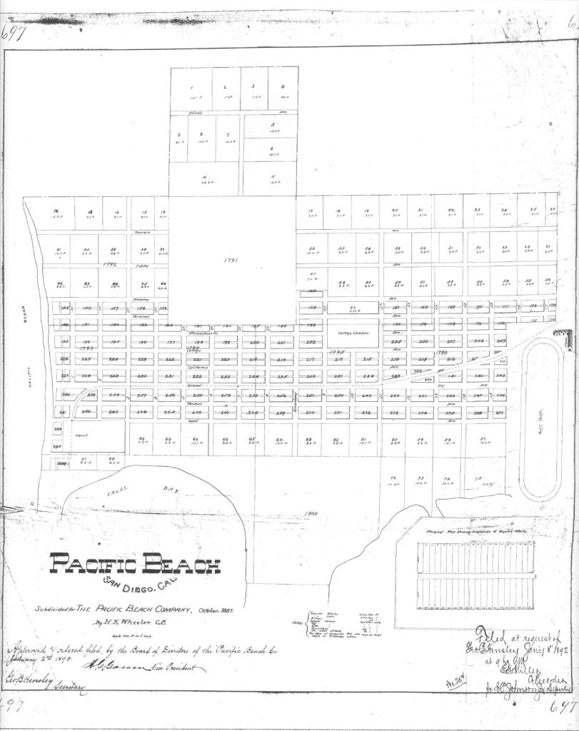
The college was intended to be the centerpiece of the new community planned for the area north of Mission Bay and east of the Pacific Ocean, and was to be built on a four-block campus now occupied by the Pacific Plaza shopping center on Garnet Avenue between Jewell and Lamont streets. At the time, Pacific Beach was almost entirely undeveloped; the Pacific Beach Company had been incorporated in July 1887, a subdivision map was drawn up in October and the opening sale of lots had been held in December 1887, just a few weeks before the cornerstone ceremony was to take place (the platform built for the ceremony may have been the largest structure around at the time). The railroad from San Diego was still under construction and passengers attending the cornerstone ceremony in January 1888 would actually have traveled over the rails of the California Southern mainline railway from downtown to Morena, where they would have switched over to a portion of the Pacific Beach line which continued from there to the vicinity of the college campus (the railway from downtown San Diego to a depot near the beach at the foot of Grand Avenue was finally completed in April 1888).

According to the Union about 2500 people traveled to Pacific Beach to witness the laying of the college cornerstone, and the green grass and the sublime scene from the college campus made the occasion a most interesting one. One of the speakers described the scene as a ‘hilltop with its slopes stretching down to the placid bay and out to the roiling sea, while in the distance, but in full view, lies the busy city and the harbor filled with ships, and beyond the majestic sweep of the mountains, some green with spring-like verdure, and others white with snow’.

When Joaquin Miller stepped to the front of the platform to read the poem he had composed for the occasion he was greeted with an ovation ‘that could not but have gratified the gifted man of verse and sentiment’. The sentiments in Mr. Miller’s verses included:

We lift this lighthouse by the sea,
The west-most sea, the west-most shore,
To guide man’s ship of destiny
When Scylla and Charybdis roar;
To teach him strength, to proudly teach
God’s grandeur, by Pacific Beach.

(Scylla and Charybdis were a pair of mythological sea monsters on opposite sides of a narrow strait, menacing seafarers forced to sail between them)

There were other orations, music by the City Guard band and an address by the president of the college company which concluded with the promise that San Diego College would become ‘a scientific and literary light-house, guiding the people of the city and the world into the golden harbor of wealth, culture, character and happiness’. The cornerstone was then loaded with copies of local newspapers, copies of the poems and addresses delivered on the occasion, coins, and a copy of the Bible. It was then lowered into place with the words ‘we lay the cornerstone of San Diego College – unsectarian but not un-Christian – her faith the faith of Christendom – her hope the hope of the civilized Christian world.’

The San Diego College of Letters was the brainchild of Harr Wagner, publisher of the Golden Era magazine which Wagner had moved from San Francisco to San Diego in 1887. He believed that San Diego was destined to become a great city and that the city was the right size to support a college, ‘not a small insignificant institute, but an institution that will compare favorably with the noted colleges of America’. In August 1887 Wagner and two other alumni of his alma mater, Wittenberg College, in Springfield, Ohio, formed the San Diego College Company ‘to erect and construct buildings to be used for colleges, universities, and in connection therewith to carry on, control and maintain colleges and universities’. Wagner’s partners in the college company were C. S. Sprecher and F. P. Davidson (who was married to Sprecher’s sister Ella). C. S. (and Ella) Sprecher’s father Samuel Sprecher had served as president of Wittenberg from 1849 to 1874 and played a major role in establishing it as a successful educational institution (Wittenberg University still exists in Springfield). Hoping to repeat this success in Pacific Beach, the partners recruited the elder Sprecher to serve as president of their new college.

The college company also came to an agreement with O. S. Hubbell, one of the founders of the Pacific Beach Company, to include the college in plans for their new town site. Accordingly, the original Pacific Beach subdivision map featured a four-block college campus near the center of the community (on College, now Garnet, Avenue). The company contracted with James W. Reid, architect of the Hotel del Coronado, to design and supervise construction of the college buildings, and following the cornerstone ceremony construction proceeded through the spring and summer of 1888.

The September/October edition of the Golden Era contained the announcement that the college would begin its educational work on September 20, 1888. It would be undenominational and would admit both sexes to all the advantages of the curriculum. One of the advantages both sexes could enjoy was the opportunity for out-door drill, summer and winter, due to the evenness of the climate. The exercise would be ‘healthful and invigorating’ and the young ladies would be allowed to form their own military company.

A Bachelor of Arts degree would be conferred on students who completed the Classical course after four years of study. Applicants for the Classical course would have to be at least 14 years of age and would be examined in Latin, Greek (or its equivalent), mathematics, history, geography, English and physiology. There would also be Scientific and Literary courses leading to comparable degrees, and for which modern languages could be substituted for Greek. Latin would be optional after the sophomore year, but students were expected to able to read the classics (in their original languages) with literary pleasure, as repositories of history and literature. Students younger than 14 or not meeting the requirements for admission could enter a Preparatory course, designed to prepare them to enter the freshman class but also to provide a course of study that was complete and practical in itself. The academic year would consist of three terms of 13 weeks each with each term’s tuition set at $16.50 for Preparatory students and $22.00 for Classical, Scientific and Literary students. Resident students would also pay $97.50 for board and room rent, and an extra fee of $10.00 was added for music, $3.00 for voice culture and elocution, and $5.00 for painting.

San Diego College of Letters, 1888, with students in their military uniforms.
San Diego College of Letters, 1888. The young ladies and young men are in their separate military companies wearing their military uniforms. (San Diego History Center #9800)

The San Diego College of Letters did open on September 20, 1888 with 37 students, and enrollment increased to 104 for the second term in January 1889. The Annual Catalogue for the 1888-1889 collegiate year included a list of the students’ names and home towns which showed that 23 of the 104 students were residents of Pacific Beach, 45 were from other areas of San Diego, 12 from Coronado and 10 from other parts of San Diego County. Only 8 students were from out of state, including two from Lower California. Judging by their names (Bessie, Hattie, Emma, etc.) 46 of the students were young ladies and 57 were young men (e.g., Horace, Edgar, Cyrus).

In addition to the grant of the college campus property, the Pacific Beach Company had given the college company hundreds of residential lots throughout the community as an endowment to secure its financial future. However, San Diego’s ‘Great Boom’ which had followed the completion of a transcontinental railroad link in 1885 and the influx of thousands of potential settlers collapsed in 1888, causing a sharp decline in the population and a corresponding lack of demand for residential real estate. The college attempted to generate interest in its lots by holding auctions where choice residence and villa sites would be sold to the highest bidder. Potential buyers were also treated to lunch, which could be roasted ox, ‘carved and served to the hungry throng’, or a fish fry. Three auctions were held in February and March of 1889 which drew large crowds but apparently few bidders. Instead, to relieve its immediate debt and other obligations, the college mortgaged much of its real estate. The financial outlook deteriorated further in April 1889 when James W. Reid sued the college company for what he claimed was owed for the design and supervision of construction of the college building.

Still, when the first academic year came to an end in June 1889 the mood at the college was upbeat. The final edition of the College Rambler, the student newspaper, included an editorial ‘to you fellow students whose years work is so nearly ended, it extends congratulations if your record has been good, its sympathy, if ill. You, like it, have been making history. You as pioneer students have helped to found a College; to rear an institution of higher learning here in this bright Sunland’. The keynote speaker at the college commencement ceremony added that it did not task the imagination to predict that the time was not far distant when San Diego College of Letters would take rank among the leading institution of learning in the country.

The second academic year opened in September 1889 with a few additions to the faculty and many of the same students. A new college building was opened in January 1890, financed by and named for Oliver J. Stough, a real estate investor with interests in Pacific Beach. Stough Hall became the popular venue for students’ elocution contests and musical recitals, watched by citizens who arrived in special trains from downtown San Diego. Closing exercises for the college’s second academic year were held in Stough Hall in June 1890.

During the summer of 1890 a number of changes were made in the administration and corporate structure of the college. The San Diego Union reported that the original partners in the college company, Harr Wagner, C. S. Sprecher and F. P. Davidson, transferred their interests in the company to ‘eastern parties’. Wagner and Sprecher both resigned from the faculty to devote their full attention to the Golden Era. Davidson remained at the college in a caretaker role, representing the new ownership, which was expected to lift the burdensome debt from the young but vigorous institution.

When classes resumed for the fall term in September 1890 about 50 students were enrolled, the majority from Pacific Beach or elsewhere in San Diego. In December the San Diego Union reported that the term had closed and all but two or three students from the East had dispersed to their homes for the holidays. If the students did return for the second term in January 1891 they did not remain for long. In March 1891 the Union reported that Captain and Mrs. Woods had moved in and taken charge of the College of Letters and added that Mrs. Woods had been a teacher there for some time and the college would be in good hands. There was no explanation for why this was necessary and no further news from the college for the remainder of what would have been the academic year. Although the San Diego Union reported in August 1891 that a Prof. Vinton Busby from Indiana State University would accept the presidency of the college and had arrived in town to make final arrangements, these arrangements apparently fell through and the San Diego College of Letters in Pacific Beach never reopened.

James W. Reid’s lawsuit over the debt he was owed for design and construction of the first college building had been decided in Reid’s favor in March 1891 and with no other assets available to satisfy the judgement the court ordered the sheriff to seize the college company’s real estate. The college campus property was subsequently auctioned at the court house door on three separate occasions over the next five years before being acquired in 1898 by Rev. William L. Johnston of the Pacific Beach Presbyterian Church, as trustee for Pacific Beach College, an organization of residents determined to reestablish an institution of learning there. Some alterations were made to the college buildings, including a tower on Stough Hall, but no progress was made toward reestablishing the college. Instead, the campus was used for various purposes including a Y.M.C.A. summer camp. In 1901 it was described as the College Inn, with W. Johnston as secretary and manager, and local news items occasionally commented on its guests (‘Mr. and Mrs. Sewel of Los Angeles spent last week at the College Inn’). Stough Hall became the center for dances and other gatherings in Pacific Beach.

In 1903 Folsom Bros. Co., a real estate developer which had recently acquired the Fortuna Park subdivisions south of what is now Pacific Beach Drive, purchased most of the rest of Pacific Beach from O. J. Stough (the Union headline read ‘Pacific Beach Has Changed Owners’) and began a program of improvement and development to enhance the value of their investment. In April 1904 they also leased the college campus (with option to buy) from W. L. Johnston and announced plans to develop the former college buildings into a first class resort. While this development was underway they held a contest to choose a name for their new resort. The name chosen (for which the lucky winner received a $100 lot in Pacific Beach or $100 in gold) was Hotel Balboa. Folsom Bros. exercised their option to buy the property in 1905 and over the next few years alterations and repairs were said to have added greatly to its attractions. In 1907 the hotel grounds were landscaped and the surrounding streets graded, ‘sidewalked’ and lined with palms trees (some of which are still growing). However, despite the efforts of Folsom Bros. Co., the Hotel Balboa also was not a success.

In 1910 Capt. Thomas A. Davis leased the buildings and grounds and started the San Diego Army and Navy Academy with 13 students and himself as the only instructor. Unlike its previous occupants, the military academy thrived and grew over the years. Davis purchased the property in 1921 and eventually added a number of larger buildings which surrounded and dwarfed the original college buildings. During the depression of the early 1930s the academy, like the college before it, was unable to repay the costs of its building program and was acquired by John Brown Schools and renamed Brown Military Academy. In the 1950s Pacific Beach growth encroached on the academy and in 1958 it moved to a new location in Glendora.

The new owners of the college campus property proceeded with plans to convert it into a shopping center and in August 1958 the San Diego Union reported that workmen razing one of the buildings on the site had found a baking soda tin in its cornerstone containing papers dating to 1887, including San Diego newspapers and a Pacific Beach subdivision map.

PB Passion Fruit Ranch

Hermann Karl Wilhelm (H.K.W.) Kumm was born in Germany in 1874. He was drawn to missionary work in Africa and served on missions in Eqypt and the Sudan in the late 1890s. In 1900 he formed the Sudan United Mission, dedicated to establishing Christianity and preventing the spread of Islam among the pagan tribes of sub-Saharan Africa. Dr. Kumm led the mission for more than twenty years and traveled widely within Africa, including areas previously unexplored by Europeans, for which he is sometimes considered the ‘last of the Livingstones’. He also wrote several books describing the lands he had visited and the lives of other African missionaries.

On one of his expeditions into the jungles of the Congo region he contracted a fever which undermined his health. His doctors advised him to relocate to a mild climate and in 1925 Kumm moved with his family to Pacific Beach, where his reputation as an explorer, geographer and writer quickly earned him celebrity status. He was chosen to be the principal speaker at the ‘formal christening’ of the new $150,000 Crystal Pier in April 1926 and the May 1926 celebration of a new road to the top of Mt. Soledad.

Dr. Kumm had moved to Pacific Beach not only for his own health but because he believed that local conditions were ideal for the cultivation of passion fruit. He had developed an interest in botany and hoped to produce a better variety of passion fruit, large and tasty, by crossing the small but highly flavored Australian variety with the larger but less flavorful South American type. The Kumms’ home at the northeast corner of Hornblend and Morrell streets (named Passiflora after the genus of the passion vine) was on ten lots, the entire southwest quarter of the block, and within a year he had started 500 seedlings and had nearly 200 plants growing, of which 50 were bearing.

In order to continue his experimentation on a larger scale, Dr. Kumm leased 20 acres of pueblo land from the city on Torrey Pines Mesa, in the vicinity of Miramar Road, in August 1927. The Evening Tribune reported that the initial planting of 5 acres was believed to be the largest area ever planted in the United States to the passion fruit vine. In April 1929 he was also granted a lease of 37 acres of city-owned pueblo land in Pueblo Lots 1780 and 1781, in the hills north of Pacific Beach where the Emerald Cove and Crystal Bay gated communities are now located (despite the opposition of the PB chamber of commerce, which felt that the property would be put to better use as a golf course).

The April 1929 lease of land above Pacific Beach coincided with an announcement in the San Diego Union that the growing of passion fruit had passed the experimental state and that acreage coming into bearing and demand for products necessitated construction of a factory and immediate development of a business; ‘Opportunity open for business man with at least $30,000 to take over complete control of manufacturing end and establish profitable business in sale of products’. While business men were considering this offer, Pacific Beach residents were given the opportunity to sample the products. When the Pacific Beach Woman’s Club met at Braemar Manor, the home of Mrs. F. T. Scripps, for her annual musical entertainment in April 1929, the refreshments included ice cream made with passion fruit from the gardens of Dr. H. K. W. Kumm. A month later, the Woman’s Club garden fete at the Scripps’ home included booths of various kinds where refreshments were served. Mrs. H. K. W. Kumm was in charge of passion fruit products.

While in Pacific Beach Dr. Kumm occasionally recounted his African travels in talks to various civic organizations. He brought trophies including the tusks of a buffalo that once treed him to a meeting of the University Club. He told the Lions Club that in 1908 he penetrated the darkest part of Central Africa and crossed the continent at a latitude where other explorers had failed. A meeting of local realtors learned that he crossed Africa on foot, accompanied only by natives, and explored lands never before touched by whites, his work bringing him many signal honors in the scientific world.

He also developed a new interest, this time in gliders. In the summer of 1929 glider clubs from around Southern California had held competitions in which gliders were launched from the top of Loring Street hill and the hills behind the corner of Fanuel and Agate streets. In November 1929, at an organizational meeting at his home, Dr. Kumm was unanimously elected president of the Associated Glider Clubs of Southern California. He and his wife also sponsored San Diego Girl Gliders and helped them to purchase their own sailplane.

H. K. W. Kumm died in 1930 of heart disease induced by the fever he had contracted in Africa. He was 56 years old. Despite his efforts, the passion fruit industry he hoped to develop in Pacific Beach never really took off. A visitor in 1931 noted that Passiflora, the Pacific Beach home of the late Dr. and Mrs. Kumm, was a particularly delightful spot to visit, with the passion fruit blossoms as well as an abundance of fruit on the vines, but regretted that Dr. Kumm could not have been spared to carry on his work at Passiflora. Mrs. Kumm returned to her native country of Australia in 1931, listing her home in the Evening Tribune; ‘Passiflora, a delightful home with an assured income at 2004 Hornblend’. According to the Tribune, 12,000 pounds of passion fruit were picked the previous year and a contract existed for the crop at 12 cents a pound. The property included a 7-room and a 3-room house, a garage, packing house, lath house and greenhouse, 75 varieties of roses, all kinds of bearing fruits and avocados, a fish pond, many fine trees, tropical plants and shrubs. ‘Was appraised at $12,000. Submit any offer over $8,000’.

Today the tropical plants and shrubs, bearing fruits, and roses that once flourished at Passiflora are all gone and the packing house, greenhouse and fish pond have given way to apartments and town houses. The Kumms’ former home at the corner of Hornblend and Morrell is now the only reminder of their Pacific Beach passion fruit ranch.

Passiflora, Dr. Kumm’s home and passion fruit ranch in Pacific Beach, now modernized with a false mansard fascia

Mt. Soledad and the Cross

Mt. Soledad Cross

Mt. Soledad, which rises abruptly to the east of La Jolla and descends more gradually south to Pacific Beach, is the highest point in the city of San Diego. At 822 feet above sea level and within about a mile of the Pacific Ocean it is also said to be the highest coastal elevation in California. With an unobstructed view from horizon to horizon it has long been popular as an observation point. In 1905, the San Diego Union’s annual New Year’s Day report from La Jolla noted that Old Soledad rose majestically, keeping watch over the town nestling at its feet, and that the half-hour’s stiff climb to the old signal station at the top was amply repaid by the panorama you would find yourself the center of; San Diego, Coronado and grand old Point Loma, the broad expanse of Rose Canyon, the mountains, and the illimitable expanse of ocean, Clemente and Catalina showing clear and distinct in the distance. If you were also one of those favored mortals privileged to see one of La Jolla’s gorgeous sunsets from that vantage point, you would return a ‘better and a wiser man for what it has been granted you to look upon’ (the ‘old signal station’ was apparently the survey station established on the summit in 1899 by A. T. Mossman of the U. S. Coast and Geodetic Survey).

In April 1908 the Union recommended the summit of Mt. Soledad as a rare natural observatory from which to get a first glimpse of the Great White Fleet, the armada of U. S. battleships that was making its first United States port call at San Diego after sailing around Cape Horn on a round-the-world voyage. The fleet’s arrival on April 13 drew the largest crowds ever seen in San Diego at the time, but La Jolla residents and visitors who did not wish to go to San Diego could view the coming of the fleet from the mountain top. Other sights were also best seen from the mountain; in April 1910 the Union reported that a comet party made its adventurous way up Mt. Soledad to gain in the clear upper air an unobstructed view of the celestial wanderer (Halley’s comet).

To make the way up Mt. Soledad a little less adventurous, in 1913 A. H. Frost, president of the San Diego Beach Company, which owned much of Pacific Beach, and Clark Bailey, a La Jolla capitalist, built a four-mile-long road from the foothills above Pacific Beach to the summit of Mt. Soledad. The Evening Tribune reported that the route started near the Pacific Beach reservoir and by an easy grade followed the contour of the hills, providing a splendid view of mountains, sea and islands. The road was improved and realigned in 1916 to connect it to the end of Lamont Street in Pacific Beach and its completion was celebrated in April of that year when 60 members of the San Diego Floral Association guided by Kate Sessions drove to the top in twelve automobiles and planted five Torrey Pines and three Mount Diablo big cone pines, grown from seed and donated by Miss Sessions. The ‘flower lovers’ declared that the view was well worth the trip to the top.

View from Mt. Soledad, 1954

Mt. Soledad lies within the pueblo lands of San Diego and in June 1916 La Jolla residents petitioned the city council to set aside the south 120 acres of Pueblo Lot 1265, described as the summit of Mt. Soledad, for a public park (actually, the highest point in Pueblo Lot 1265 is 811 feet; the 822-foot summit of Mt. Soledad is about half a mile west, within Pueblo Lot 1264). The council voted unanimously to approve the petition and the south 120 acres of Pueblo Lot 1265, ‘commanding a view of the ocean, mountains and of the entire city’, became a city park in July 1916.

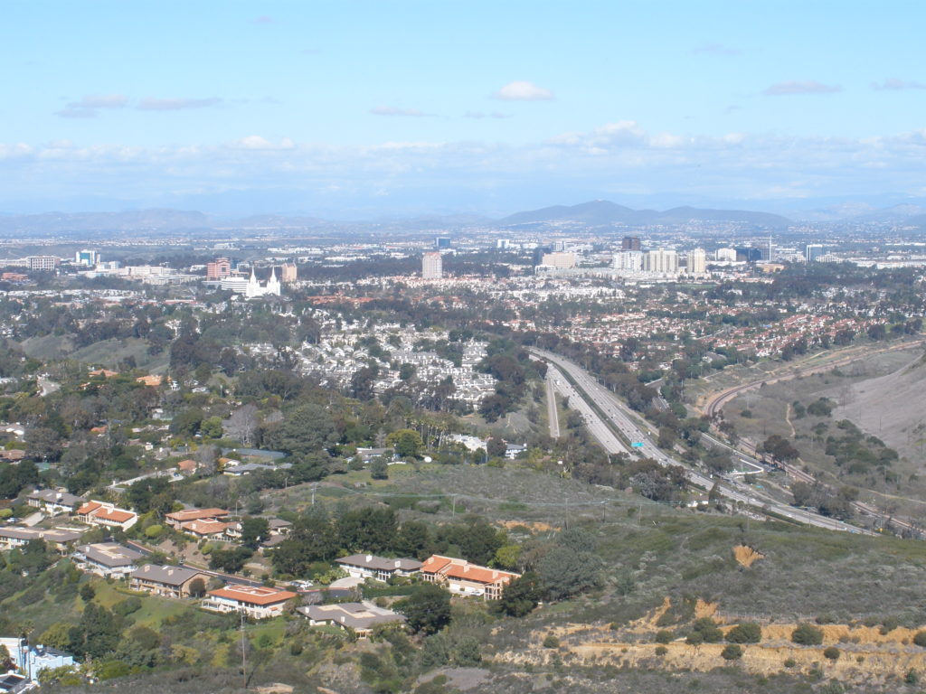
View from Cross today
View from Mt. Soledad today

In 1926 the chambers of commerce of La Jolla, Mission Beach and ‘San Diego Beach’ (the would-be name for a hoped-for redevelopment of Pacific Beach) formed the North Shores Civic League to promote their communities. The League noted that a neglected feature of the North Shores area was the wonderful scenic panorama that could be observed from Mt. Soledad and they recommended that the ‘fair trail’ from Pacific Beach to the summit should be developed into an auto road. According to the San Diego Union, citizens of La Jolla and Pacific Beach assembled with shovels and rakes and aided by scrapers furnished by the city performed wonders in turning the trail into a serviceable dirt road by which autos could reach the summit in high gear. The completion of this ‘new road from the south’ was the occasion for a celebration at the summit in which Dr. H. K. W. Kumm, ‘traveler, writer and lecturer’ (and Pacific Beach resident), declared that while such sights as the Grand Canyon and Victoria Falls might be more awe-inspiring, they could hardly be considered more beautiful than the view from Mt. Soledad (although the San Diego Union admitted that the day was a trifle hazy and the usual clear view of the mountains was obscured). Kate Sessions planted three more pine trees and cadets from the Army and Navy Academy in Pacific Beach were in charge of a military ceremony and flag raising.

For more than 80 years now the top of Mt. Soledad has been marked by a large cross, standing over 30 feet tall. There are reports that a redwood cross was dragged up the mountain with a good deal of labor and patience and that worshipers held Easter services beneath it in 1913, but if so it was probably not at the same location as the current cross. The San Diego Union announced in 1914 that the churches of La Jolla would hold a joint sunrise Easter service at the reservoir, presumably meaning what is now the Exchange Place reservoir in La Jolla, and in the early 1920s the churches again joined to conduct Easter sunrise services near the clubhouse of the La Jolla golf course. The redwood cross was reportedly stolen in 1922, but if this cross ever existed it was probably located at one of these sites on the lower slopes of Mt. Soledad.

View from Mt. Soledad, 1953

By 1925 the Union reported that Easter sunrise services had become an annual institution in La Jolla and attracted increasingly large crowds each year. In 1929 plans were announced for the sunrise service to be held by the pastors of North Shore protestant churches at a ‘scenic point on Soledad Mountain’. According to the Tribune, the Pacific Beach chamber of commerce had cleared the ground on Mt. Soledad and would clear the road up the mountain from Pacific Beach. The PB Boy Scout troop had agreed to take a hiking trip from the head of Lamont Street to the scenic point a few days before Easter and throw any stray rocks and pebbles out of the road. Representatives from La Jolla were also expected to clear two other routes from La Jolla, opening up three avenues of traffic to help avoid congestion. A special committee was appointed to supervise the erection of a cross and platform. The ‘scenic point’ was apparently the city park on Mt. Soledad, which was to become the site of annual Easter sunrise services in the coming decades.

View from Mt. Soledad today

One thousand residents of the North Shore district attended the first Easter sunrise service at the park on Mt. Soledad in 1929 and the Evening Tribune reported that a two-mile chain of torches along the highways leading up to the mountain had been arranged in the form of a gigantic cross. An Easter sunrise service was also held on Mt. Soledad in 1930, attended by 500, but the custom then apparently lapsed until being revived in 1934 under the auspices of the Pacific Beach chamber of commerce. In March 1934, just a few days before Easter, the city built a ‘frame stucco cross’ in the city park and on Easter morning hundreds of residents gathered before the cross as Army and Navy Academy buglers heralded the beginning of the service.

Easter sunrise services at the cross on Mt. Soledad became an annual event but just before Easter in March 1952 the San Diego Union reported that the weather-scarred old cross, pitted with BB shot launched at it by mischievous youngsters and buffeted through the years by the elements, had been toppled by wind and shattered beyond reasonable repair. The Union noted that city employees had patched, stuccoed and strung framework over chicken-wire fabric to construct the 30-foot cross and that throughout its existence it had withstood all influences except one: an act of God.

Plans to replace the stucco cross began immediately and contributions were accepted at the 1952 Easter sunrise service. In May 1952 the Mt. Soledad Memorial Committee announced that plans were nearly completed for a ‘lasting cross’ atop ‘historic Mt. Soledad’. The proposal included a new cross of reinforced concrete as well as a paved assembly area large enough for several thousand persons, a parking area for 800 or more automobiles and about 2000 feet of new highway.

In 1953 the 32nd annual Easter sunrise service was held at the site of the old cross. A temporary cross was erected and an offering taken to go towards rebuilding the cross. By September the Memorial Committee had obtained sufficient funds for building and maintenance of the cross and grounds, and announced that construction would begin as soon as city approval was gained. Actual construction involved pouring twenty tons of concrete into forms laid out on the ground and allowing it to cure for 60 days. However, when a pair of cranes attempted to raise the cross into position in February 1954 its weight produced ‘certain stresses that it wouldn’t take’ and it cracked in two places just below the horizontal section of the cross. Contractors, engineers and architects studied the problem and decided they could remove and recast the cracked section and still have the cross in place before Easter. In fact, the cross was repaired and raised in time to be dedicated on Easter Sunday, 1954. The paved assembly area and parking lot for thousands of people originally proposed by the Memorial Committee was never built.

La Jolla topographic map showing Mt. Soledad, 1953

The cross built within the city park on Mt. Soledad in 1934 and rebuilt in 1954 was specifically intended for Easter sunrise services, and for years maps identified the site as the Mt. Soledad Easter Cross. However, in the 1980s, the presence of a prominent religious symbol on public property in apparent violation of the constitution led to lawsuits, and at one point a court ordered the cross to be removed. Instead, the constitutional issue was resolved by returning the land under the cross to private ownership.  The Easter cross became the Mt. Soledad Veterans Memorial Cross, a tribute to armed forces servicemen and women, and in 2006 the property was taken over by the U. S.  Department of Defense. After an act of congress in 2014 allowed it to be transferred to private ownership it was sold to the Mount Soledad Memorial Association in 2015. In September 2016 the courts ruled that since the cross no longer stood on public property the case for its removal was moot.

The legal battles may now be over, the cross on Mt. Soledad is still standing, and the panorama a visitor may find themselves the center of amply repays the few minutes it now takes to drive to it.


Original PB Ranch House

In February 1892 the San Diego Union reported that Pacific Beach was to have quite an increase in the way of permanent residents:

It was learned yesterday that nine easterners had each purchased a ten-acre lot, all joining and situated just above the College of Letters. Eight teams are now at work breaking and preparing the soil for improvements that are to be made. The purchasers are in the city, and they intend planting the entire ninety acres in fruit, with the exception of sufficient space on which to build residences this spring.

The adjoining ten-acre lots were the ‘acre lots’ which had just appeared on a new map of the Pacific Beach subdivision, filed in January 1892. Although the original PB subdivision map from October 1887 had divided the entire community into uniform residential blocks, property in the outlying areas had not sold well and the new map consolidated most blocks north of what is now Diamond Street into the acre lots, intended for agricultural uses. As the Union had observed, these acre lots proved to be extremely popular and more than a dozen of them were purchased in the first months of 1892, most just to the north of the college campus, later the San Diego Army and Navy Academy and Brown Military Academy, and now the Pacific Plaza shopping center (the college itself had closed the year before, in 1891).

Detail from 1892 PB subdivision map showing acre lots north of the college campus (modern street names added)
Portion of 1892 PB subdivision map showing acre lots north of the college campus (modern street names added)

Two of the easterners, brothers-in-law and business partners from Henning, Tennessee, actually bought three adjoining acre lots which met at the corner of what are now Chalcedony and Lamont streets. R. C. Wilson and G. M. D. Bowers were Confederate veterans and proprietors of Wilson & Bowers, general merchandise, in Henning, and Wilson had married Bowers’ sister Susie in 1879.  In February 1892 Wilson and Bowers jointly purchased Acre Lots 34 and 50 and in March 1892 they added Acre Lot 33 of Pacific Beach. Lots 50 and 33 were on the east side of Lamont; lot 50 between Diamond and Chalcedony streets and lot 33 between Chalcedony and Beryl. Acre Lot 34 was between Chalcedony and Beryl but west of Lamont, extending to what is now Kendall Street. The price was $100 an acre; $1850 for lots 34 and 50 and $990 for lot 33. A year later Wilson and Bowers also bought Acre Lot 51, east of lot 50 and extending to what is now Noyes Street, for $830.

By the end of March 1892 the San Diego Union reported that 4,000 feet of water pipe was being laid over this 30-acre tract and that the property was to be put in lemons during the next few weeks. The new owners had also reserved sufficient space on which to build their residences. The Bowers built their home on Acre Lot 34 in 1892, the first ranch house to be built on a Pacific Beach lemon ranch, and moved in with their five children. The Wilsons, with two children, built in 1893 across Lamont on Acre Lot 33.

The development of lemon ranches on the acre lots combined with facilities for curing, packing and shipping lemons brought a decade of relative prosperity to Pacific Beach. The ranchers and their families became prominent in Pacific Beach society and their activities were noted in San Diego newspapers. In one example from 1893, the Union reported that Miss Eddie Sue Bowers and Miss Annie Bell Wilson wore dainty costumes of cream color to a joint birthday party for Miss Evangeline Rowe and Miss Mary Barnes, who in their soft pink gowns were ‘like two rosebuds in their fresh girlish beauty’ (the Rowe lemon ranch was just south of the Bowers, in Acre Lot 49; the Barnes ranch was Acre Lot 64, just south of the Rowes).

Pacific Beach lemon ranches could generate profits over time selling lemons for a few cents a pound, or all at once by selling the ranch itself for thousands of dollars. Wilson and Bowers chose the second option, beginning with the eastern portion of Acre Lot 51, which they sold in June 1894 for $500. Lot 33, including the Wilsons’ home, was sold in September 1895 for $5500. In October 1895 both lot 50 and the western portion of lot 51 were sold, for $3000 and $1000, and lot 34, with the Bowers’ home, was sold in November for $5500. Both families then returned to Henning, Tennessee, having realized a gain of nearly $12,000 on their Pacific Beach real estate investments.

On Acre Lot 33, the family of Ozora Stearns and, after 1899, Carrie Linck lived in the Wilson ranch house while shipping carloads of lemons from the ranch. After 1901 the property passed through a series of five absentee owners until it was sold in 1904 to the Layman family, who remained on the ranch for the next thirty years. The Stearns had named the ranch Vencedor, but the Laymans renamed it Seniomsed (Des Moines, their former home, spelled backward). In 1947 Acre Lot 33 was included in the Lamont Terrace development (the homes with the brick chimneys and shingle siding) and the former ranch house was torn down, leaving only a Moreton Bay Fig tree to mark its place. Across Lamont Street in the former Acre Lot 34, however, the Bowers’ home remains as a monument to PB’s lemon ranching past.

The Bowers had sold Acre Lot 34 to William Davis, a mining engineer, who moved in with his wife and sister in December 1895. Two children were also born to the Davises while living on their Pacific Beach ranch. Mr. Davis spent much of his time at the Arizona mines and his sister, Louise, may have actually run the ranch. She may also have been the one who gave the ranch its name; in June 1896 the Union reported that Miss Davis had shipped 84 boxes of choice lemons from Ondawa Ranch.

In May 1898 the Davises sold Acre Lot 34 to James and Sarah Jowett and by July Mr. Jowett was said to be making extensive additions to the barn and putting flumes all over the ranch. However, the Jowetts also moved on after a few years, selling Acre Lot 34 in December 1901 to Ires E. Cobb, who sold it a few months later, in May 1902, to Walter and Louisa Boycott for $5000.

Mr. Boycott was a retired publisher from La Crosse, Wisconsin, and according to the Evening Tribune he came to San Diego with his family to enjoy the salubrious climate and profit from the good times just in sight. By July 1902 the Tribune reported that the family was enjoying their new home and Mr. Boycott was fertilizing heavily and picking a fine quality of fruit from the heavy Lisbon lemon trees. A year later, in June 1903, the good times apparently came in sight for the Boycotts and they sold the ranch for $6000 to Abraham and Adelaide Manny, who changed the name of the ranch from Ondawa to Las Flores. When Miss Virginia Manny entertained a pair of her friends from Los Angeles in 1906, the Union noted that the young women were delighted with Pacific Beach, as well they might be, since the view from the floral bowers of Las Flores, over banana trees, palms and lemon orchards, to the bay and Mexican mountains, was unmatched.

Lemon ranching in Pacific Beach had begun with the development of the acre lots in 1892, particularly the Wilson and Bowers properties, and lemons had supported the community for over a decade, but by 1906 many people foresaw that PB’s future prosperity would come from residential development, not agriculture. In December 1906 an advertisement appeared in the San Diego Union for an elegant Pacific Beach residence, with city water, all modern conveniences, highly improved grounds, on ½ acre or more, only a short distance north of the depot, in ‘block 34’. The ad also offered lots in block 34, with fine fruit trees and water on each lot, prices low, terms easy, illustrated description free, A. J. Manny, owner (the ‘depot’ was the Lamont Street stop on the railroad between San Diego and La Jolla, which ran along Grand Avenue).

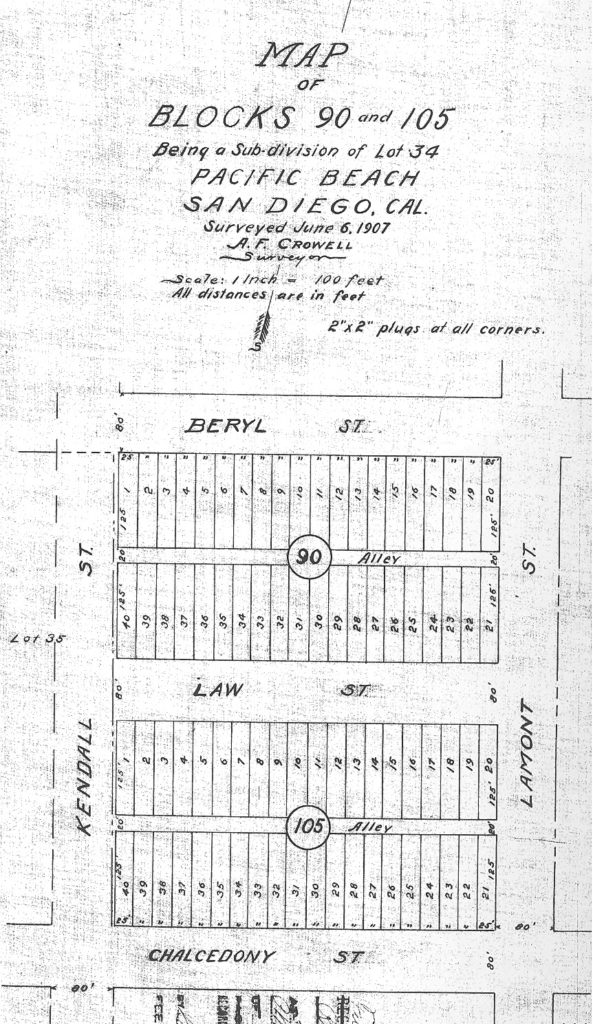
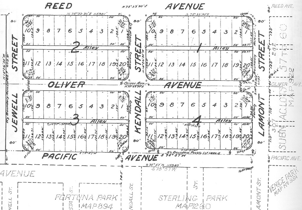
Although Manny apparently had intended to sell the ranch house and the other lots separately, in fact the entire acre lot was sold in January 1907 to Robert Ravenscroft. By 1907 a number of the Pacific Beach acre lots had already been re-subdivided back into city blocks, including the lots immediately west and south of lot 34, and in December 1907 Ravenscroft followed suit, recording a subdivision map that turned Acre Lot 34 back into the two blocks shown on the original 1887 map of Pacific Beach, along with their original block numbers. Like the other blocks on the original map, Block 90, south of Beryl Street, and Block 105, north of Chalcedony Street, were divided into 40 25- by 125-foot lots with a 20-foot-wide alley through the center of each block, connecting Kendall and Lamont streets. The 80-foot-wide street between the blocks, Florida Avenue on the original map, was re-dedicated to the city and became an extension of Law Street.

Blocks 90 and 105

Subdivision of Acre Lot 34 into 80 individual lots meant that the ownership and any improvements on each lot was recorded in the city lot books. The lot book data shows that from 1908 to 1911 the Ravenscrofts continued to own every lot in the subdivision and that the only improvement, the original ranch house, was valued at $425 and located on lots 17-20 of Block 105, a location at the southwest corner of Law and Lamont streets. In 1913, the lot book entry for lots 17-20 in Block 105 no longer showed improvements but instead contained the note ‘Imps on blk 90’, and the lot book entry for Block 90 showed a new improvement valued at $425 for lots 25-27. This suggests that the ranch house had been moved across Law Street and down the block to its present location at 1860 Law.

The lot books also showed that in 1911 three lots on the south side of Block 105, lots 29-31, were sold to Ferdinand Defrenn. In November 1911 a building permit was issued to F. Defrenn for a 6-room cottage on Chalcedony Street valued at $1700 (although that home, at 1838 Chalcedony, was destroyed by fire in 1927). In the next few years the Ravenscrofts sold most of the remaining lots on the south side of Block 105 while continuing to own all of Block 90 and the lots on the north side of Block 105. The Defrenn’s home on Chalcedony was rebuilt but no other homes were built in the subdivision over the next 30 years.

Miss Susie Ravenscroft, a 19-year old telephone operator, was married at home in 1911. The Evening Tribune reported that the ceremony took place in the front parlor under a canopy of ferns and smilax ‘thick starred with Shasta daisies’. The back parlor decorations were of pink roses and ferns. Punch was served in the large sun-parlor. Several kodaks were produced and there were many pretty groupings on the front lawn of the spacious Ravenscroft grounds.

Robert Ravenscroft died in 1916 and in 1923 the Ravenscroft family’s holdings in blocks 90 and 105 were sold to Cameron Hutton, secretary-treasurer of a downtown sheet metal fabrication and auto body shop. In 1925 Hutton also reacquired six of the lots in the south half of Block 105 that had been sold by the Ravenscrofts.

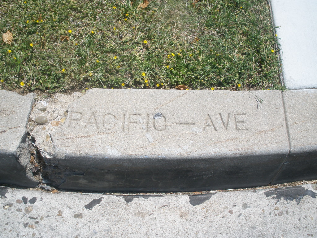
In 1922 the city council ‘closed up’ Law Street between Kendall and Lamont streets and the alleys in blocks 90 and 105 for the ‘public interest and convenience of the city’. Although the street and alleys had been mapped and dedicated fifteen years earlier there had been no actual grading or other improvement, and no new construction requiring access, so these closings would have had little practical effect. The 1923 – 1927 lot books contained a notation that Law St. and all alleys were closed in 1922, but this notation was scratched out in the 1928 lot book, presumably indicating that the street and alleys had been reopened. When Lamont Street was paved in 1928 between Garnet Avenue and the city property that became Kate Sessions Park, the project included the curbs and sidewalks along blocks 90 and 105 which remain today.

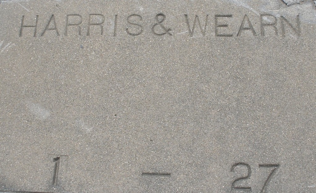
R. W. Brown Paving

The former ranch house was vacant in 1928 but from 1929 to 1933 it was home to Roscoe Porter, a real estate operator. His son David Porter recounted in a 1995 interview for the San Diego Historical Society’s oral history program that the family moved to a ‘great big old Victorian house’ two or three blocks north of the Academy on the corner of Lamont and Law Streets where they had eight acres of fields and orchards with strawberry patches, tangerines, orange and grapefruit trees, lemons, pears and apricots.

In November 1933 ads appeared in the San Diego Union for Vista Villa Rest Home ‘for particular people; sea air, wide verandas, large rooms, food to your needs’. If you needed rest, quiet, right thinking and proper diet, you should live at Vista Villa, 1860 Law St.; ‘Broad verandas, large grounds. Exclusive’. The rural nature of the property was also still evident in a 1938 advertisement for a big work horse, kind and gentle, for sale, cheap, 1860 Law St., Pacific Beach.

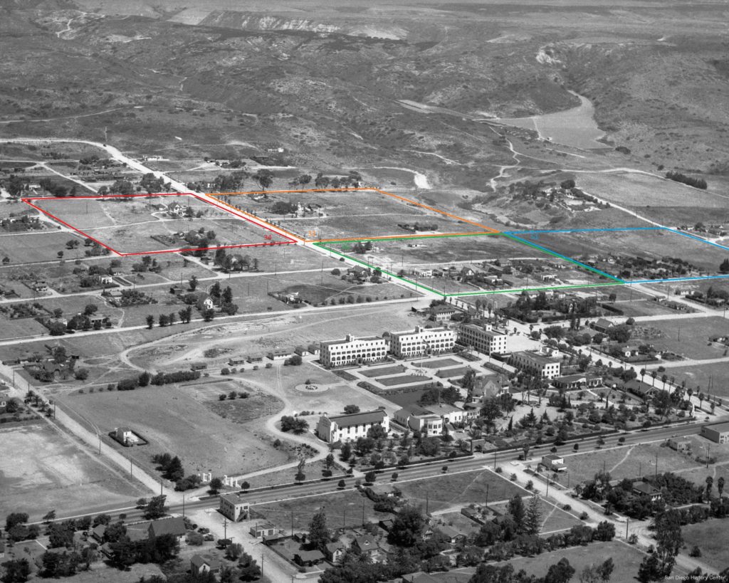
1937 aerial view of Pacific Beach. Brown Military Academy, the former college campus, is in the foreground with the land once covered by lemon ranches beyond. The acre lots originally owned by Wilson and Bowers are outlined.
1937 aerial view of Pacific Beach. Brown Military Academy, the former college campus, is in the foreground with the land once covered by lemon ranches beyond. The acre lots originally owned by Wilson and Bowers are highlighted (San Diego History Center 83:14603-1).

However, major changes occurred in San Diego beginning in 1935 when Reuben Fleet moved the Consolidated Aircraft Corporation from Buffalo to San Diego. Consolidated and other local aircraft manufacturing companies experienced explosive growth as demand grew for military aircraft in the years before and during World War II. Tens of thousands of aircraft workers who came to San Diego required homes and many found them in Pacific Beach, only a few miles away from the downtown factories.  In 1942 there was still only the one home on Law and one on Chalcedony but by 1947 houses lined the streets in what had been Acre Lot 34 and today it is hard to imagine that the area could ever have been a ranch, except for the original ranch house that still stands above it all.

PB and the Mattoon Act

Pacific Beach experienced a period of growth in the mid-1920s, including a new business district at the corner of Garnet Avenue and Cass Street, Crystal Pier and the opening of new subdivisions like Pacific Pines, North Shore Highlands and Crown Point. However, this growth soon stalled and was followed by a period of stagnation that lasted through most of the 1930s. While the Great Depression which followed the stock market crash of October 1929 undoubtedly played a role, many blamed this slowdown on the Mattoon Act.

The Mattoon Act, or Acquisition and Improvement Act, was passed by the California legislature in 1925. Named for its author, Everett Mattoon, it was intended to facilitate community development by allowing local authorities to create improvement districts where property owners would be assessed to pay for construction projects which benefited the district. The authorities would also have the right to acquire property for an improvement project through condemnation, if necessary.

Promoters of an improvement project would petition the local government authority to approve a project and an assessment district created to pay for it. While approval of a project did not require a vote of property owners in the district, a signed protest by 51 percent of the owners would be required to stop it. Once a project was approved and a district established the project would be funded by bonds to be repaid by an ad valorem tax on property owners within the district. A collective lien was placed on all property in the district, remaining in effect until the assessment for the entire district had been paid in full. Any delinquent payments were to be added, or ‘pyramided’, onto the district’s assessment for the next year, in effect requiring owners who did pay their taxes to pay their neighbors’ delinquent taxes as well.

The impact of the Mattoon Act on Pacific Beach was primarily the result of one project, the Mission Bay Causeway, a roadway built across what had been mud flats and open water between West Point Loma Boulevard and Crown Point. In April 1927 a petition was filed with the San Diego City Council asking for construction of a causeway under the provisions of the Mattoon Act. The San Diego Union reported that the project would be of immense proportions, costing thousands of dollars, and would mean the creation of an extensive assessment district north of the bay and on the Old Town flats, with the issuance of 6 percent bonds. A month later, in May 1927 the council voted unanimously to begin proceedings which could result in the construction project, estimated to cost about $500,000.

The causeway project was not without opposition, however. Attorney H. C. Gardiner, representing 150 Pacific Beach residents, protested that it was an unwarranted and unnecessary burden and threatened to fight it in court. After the council adopted a resolution of intention in August 1928, and set a date a month later to hear protests, Gardiner outlined his objections in a letter to the Union, complaining about the cost of the project, its potential to spoil Mission Bay, and the Mattoon Act itself, recently condemned by the Real Estate Association of San Diego and already in ill repute due to its ‘vicious provisions’ and ‘objectionable features’. In their September meeting, the council overruled these protests and formally authorized the project.

In November 1928 the council voted four to one in favor of issuing bonds and acquiring rights-of-way for the causeway project, again sweeping aside protests. In December, opponents of the project, led by Gardiner, filed another protest with the city council, claiming that the Mattoon Act was purely a street improvement measure and conferred no authority for the construction of bridges, which was the greater part of the Mission Bay Causeway project. When construction actually began, later in December 1928, Gardiner filed suit, and in January 1929 a judge granted a temporary injunction, halting the work.

In what was called one of the most bitterly fought court cases in recent years (attorneys were said to be like ‘gladiators sparring for position’) the project was nearly struck down in April 1929 when the judge ruled against 36 separate objections to the project but upheld one, that the proposed right-of-way crossed a small section of federal property and that the permit to cross this land was revocable by the Secretary of War and therefore did not represent a permanent dedication to the public (the property in question had been acquired by the federal government in 1878 to build a levee to divert the waters of the San Diego River into Mission Bay). Judge Griffin was prepared to make the temporary injunction against the causeway project permanent, but before his final ruling the attorney representing the promoters of the project made a ‘spectacular dash’ across the continent by air mail plane to Washington, D.C., returning with a permanent easement for a right-of-way for highway purposes signed by the Secretary of War. The judge reopened the case and reversed his former decision, although he did permit the injunction to stand pending appeal, provided the plaintiffs posted a $50,000 bond. The protesters were unable to raise the bond, Judge Griffin lifted the injunction, and construction work was resumed in July 1929.

With the Mission Bay Causeway finally under construction, some prominent Pacific Beach residents expressed positive opinions about the project. J. M. Asher Jr., who lived in his recently completed mansion at the top of Loring Street hill, was quoted as saying that his interests in Pacific Beach led him to be enthusiastic about the causeway; ‘I am convinced that land owners here will find it a great factor in the rise of property values’. An ad in the Evening Tribune in February 1930 noted that San Diego residents could already drive from Barnett Avenue to the south end of the causeway and if they did they would grasp the significance of the statement that the new causeway would effect such a transformation in Pacific Beach as it has never known. A transformation not only in the lives of its people but also in Pacific Beach real estate values. ‘But you should invest here now! Later may be too late for maximum profit’.

The new causeway did effect a transformation in Pacific Beach, in the lives of its people and in real estate values, but not in the way that its promoters had hoped. By 1930 the negative effects of the Mattoon Act were already being felt in districts around the city and county. The assessments added to property taxes to repay improvement bonds both increased the cost of ownership and reduced the value of the property, and increasing numbers of owners were either unable or unwilling to make their payments. The pyramiding provision of the Mattoon Act meant that these delinquent payments could be added to future assessments, which even more owners would fail to pay, creating a potential death spiral of rising assessments and more delinquencies.

In January 1930 a joint meeting of city councilmen and county supervisors pledged all possible relief for owners of property in Mattoon Act assessment districts. It was the ‘sense of the meeting’ that there should be no further pyramiding of assessments and that each landowner should be required to pay only his share of the cost of the improvement for which the district was formed. If bondholders did not agree they should take their case to the state courts, where the local officials believed they would find no legal basis for pyramiding. In August the supervisors established a revolving fund of about $60,000 to eliminate the year’s delinquencies on bond payments and also canceled penalties on delinquencies. According to the Evening Tribune, these measures created a ‘better feeling’ about tax bills in local Mattoon districts.

Construction of the Mission Bay Causeway was completed and a grand opening was held in January 1931. Four cadets from the San Diego Army and Navy Academy in Pacific Beach officially cut the ribbon at the south end of the roadway at Rosecrans Street. The Tribune noted that the large crowd was sprinkled by residents of Pacific Beach, Crown Point and owners of adjoining property who would pay the bills. The opening of the causeway was also accompanied by renewed advertising for Crown Point and other subdivisions in Pacific Beach.

However, delinquencies within Mattoon Act districts, including the Causeway district, continued to increase, exacerbated by the general economic collapse of the Great Depression. In February 1931 the county assessor reduced tax valuation of property in Mattoon districts by approximately 50 percent. Although he said the reduction was effected to bring relief to overburdened property owners, he noted that it was also justified by the present sales value, or lack of it, in the territory bearing heavy improvement assessments. The large, and growing, tax burden on property in these districts undermined its value, in some cases making it unsaleable.

Relief for overburdened property owners and increased delinquencies also meant that improvement districts did not raise enough revenue to make scheduled payments to bondholders. In August 1933 holders of Causeway bonds, led by the American Securities Company, won a state supreme court ruling that would have forced the city to levy a special tax to make up $31,000 in delinquent interest payments. In April 1934 the court also ruled in favor of the securities company’s demand that the city pyramid all amounts delinquent to date in the next year’s assessment. James Abbey, deputy district attorney in charge of Mattoon litigation, objected, predicting that pyramiding would result in immediate and total collapse of Mattoon Act districts, that taxpayers would no doubt refuse to pay any further assessments when they saw their tax bills, and that the situation should bring the bondholders of Mattoon Act districts to the realization that there is very little prospect for immediate payment of their bonds. Supervisor S. P. McMullen actually advocated a tax strike by property owners; ‘It’s getting better all the time for the property owners’, he said. ‘The more penalties accrue, the quicker the owners will realize how impossible it is to carry their burden, and they will quit paying taxes at all and thus force the bondholders to terms’. Rather than comply with the state supreme court ruling, the city appealed to the United States Supreme Court in July 1934 to halt pyramiding in the Mission Bay Causeway district on the grounds that pyramiding would amount to illegal taking of property without due cause, but in January 1935 the United States Supreme Court upheld the constitutionality of the Mattoon Act in the Causeway district, denying the city’s appeal.

The June 7, 1935, San Diego Union ran to 134 pages; 28 pages of news and advertising and over 100 pages dedicated to a delinquent tax list, eight columns to a page, listing the owners, descriptions and amount of taxes delinquent for property in the county. In some of the newer subdivisions in the Pacific Beach area like North Shore Highlands, Congress Heights, Pacific Pines and Crown Point, nearly every lot in the tract appeared to be listed. Some prominent citizens were included on the list, like Kate Sessions, who owed $152.92 on property in her Soledad Terrace subdivision and $66.86 on her nursery in the Homeland Villas No. 2 tract as well as additional taxes on other properties around the city. J. M. Asher Jr. owed $91.34 on the property in Acre Lot 11, where he had built his house at the top of Loring Street hill. The San Diego Army and Navy Academy, located on 31 acres in the heart of Pacific Beach that is now the Pacific Plaza shopping center, and with improvements that included recently completed 4-story dormitory buildings, was delinquent by over $8000. For the academy, this failure to pay property taxes was a fatal blow. Overextended by the dormitory building program, founder Thomas Davis had been forced to mortgage the property, buildings and furnishings, down to the silverware in the mess hall, to Security Trust & Savings Bank of San Diego. One of the conditions of the resulting deed of trust was that the academy would be responsible for property taxes, and when Davis failed to pay the delinquent taxes the trust company declared default in 1936. The campus was sold to the John E. Brown College Corporation in 1937 and was known thereafter as Brown Military Academy.

Although the U. S. Supreme Court had denied their last legal defense against pyramiding delinquent Mattoon assessments, it was obvious to local officials that pyramiding was not a viable option. According to deputy district attorney Abbey the situation had ‘just gone plain crazy’; the law seemed to give no alternative but to pyramid but under pyramiding many a lot would be called upon to pay a district assessment at least five times as great as its assessed valuation. The Causeway district was already 54 percent delinquent and if the assessments were pyramided, they would become 100 percent delinquent, like many districts already were. The county assessor added to the alarm, saying that the 100-page delinquent tax list spoke for itself; out of 155,000 real estate accounts the previous year approximately 80,000 were delinquent. Also 16,000 had been removed from the tax rolls for being delinquent over five years, reducing the tax rolls to 139,000. The supreme court order would add $3,500,000 special taxes to pay in addition to the regular levy, and the possibility of payment of such a huge sum was ‘far beyond the realm of possibility’. All such districts would without doubt go 100 percent delinquent and another 20,000 accounts would go off the rolls.

Instead of pyramiding more taxes on property owners in assessment districts, most of whom could not or would not pay them, the county proposed a $2,600,000 bond issue which would be used to buy up the existing Mattoon Act bonds at deep discounts. About half of this county bond would then be repaid by property owners in the districts, but with reasonable assessments so that the owners would resume paying their taxes. The other half would be repaid from general property taxes and gasoline taxes, reflecting the fact that much of the improvement work had involved the construction of arterial roads that actually benefit the entire region, not just the district in which they are located.

Abbey had prepared legislation enabling the Mattoon settlement plan which was introduced by the San Diego county delegation and enacted during the 1935 session of the state legislature. The settlement plan was put to a vote in San Diego County on October 29, 1935, and passed by a margin of 3 to 1. The San Diego Union celebrated it as not only a relief measure for assessment-burdened property, allowing it to be returned to general taxation and affording owners a practical method of repaying their obligations and clearing their titles, but also as a ‘Go’ signal, clearing away the wreckage from an era of reckless and unscrupulous promotion and promising renewed initiative and foresight to back projects for future progress.

The state supreme court upheld the Mattoon settlement legislation in July 1936 and in March 1937 Abbey went to San Francisco to negotiate with representatives of a large block of Causeway district bonds, which the county was to buy and retire at 50 percent of their face value. According to the San Diego Union, the district was 65 percent delinquent in city and county taxes because of the Mattoon blight. It had approximately 1500 taxpayers and included lands from the Marine base to La Jolla. In June 1937 the Union announced that settlement of the Causeway Mattoon district was voted unanimously by the county board of supervisors. $730,000 of the $743,000 bonds were in the county treasurer’s office and money was available to pay for them at the county’s price.

The Causeway district had the largest area of any Mattoon district in the county, with 56 percent or over half of the assessed valuation of such districts, and a Union editorial noted that clearing up 56 percent of the Mattoon blight meant that the hardest half of an extremely difficult task was almost finished. A solution to the Mattoon problem, a disastrous community blunder, would lift an immense worry from the literally thousands of local residents involved in the maze of legal complications created by promoters, salesmen and contractors who exploited the Mattoon Act as an easy means of making a quick cleanup in San Diego. The settlement would free the community to begin again where it left off nearly 10 years before when a small minority of individuals deluded the rest of the community with reckless promise of sudden and unearned speculative profit.

Title insurance companies agreed to issue title insurance policies in the Causeway Mattoon district without mention of the fact that the properties had been in such a district. The policies would include a note saying that San Diego County had forever waived the right to levy future Mattoon assessments on land in the district. An ad in the Union by the Southern Title and Trust Company announced that the company would insure titles in the entire Causeway district showing the property to be clear of Mattoon bonds as long as there were no delinquent assessments.

On the Fourth of July, 1937, Pacific Beach celebrated the Causeway district’s ‘declaration of independence’ from Mattoon Act ‘bond-age’ with fireworks and a huge ‘bond-fire’ at the beach, symbolizing burning of the last Mattoon bonds. City and county officials and citizens who had labored long to release the district from the heavy Mattoon yoke joined in the festivities (James Abbey had the privilege of throwing the first bundle of bonds on the fire), and predicted an era of progress and prosperity. The president of the Pacific Beach Chamber of Commerce declared that nothing could stop Pacific Beach now; ‘Our unfortunate experience with Mattoon bonds set back our development, but only temporarily. From now on watch us grow’.

Ben-Hur Coffee

Ben-Hur Coffee

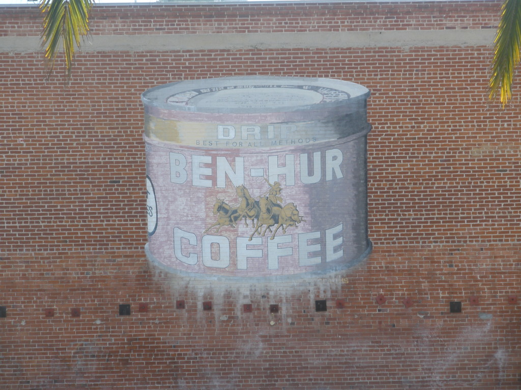
Visitors to the vicinity of West Ivy Street in San Diego’s Little Italy district often comment on a mural painted on the brick wall visible from India Street (and the Ballast Point tasting room). The mural depicts a can of Ben-Hur drip coffee (best for all methods, vacuum packed to protect freshness), complete with its logo of a chariot and four charging horses. The mural seems to be old – the Ben-Hur brand of coffee and spices originated as a tie-in to the popular 1925 silent movie and disappeared in the 1950s – but it actually dates from 1982. However, it does mark the building where the popular coffee was once produced and which was home to what is considered to be the first coffee company in San Diego.

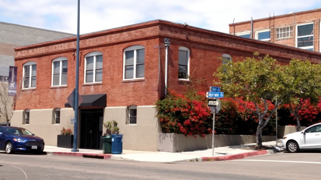
In January 1913 the San Diego Union reported that work had been commenced on a modern brick factory building for the Adams-Henry Company, successors to G. H. Ballou & Co., dealers in coffees, teas and spices, on the northeast corner of Ivy and Arctic Avenue (now Kettner Boulevard). The location was considered ideal for a building of this kind on account of its proximity to shipping; it fronted on the tracks of the Los Angeles & San Diego Beach Railroad (the La Jolla line) along Arctic Avenue, was one block from the yards of the Santa Fe railroad and was close to the harbor improvement work. G. H. Ballou had founded the company in 1889 to supply coffee to a handful of local groceries and in 1896 he was joined by Arthur Cosgrove. By the time Cosgrove retired in 1906 the firm of Ballou & Cosgrove was shipping coffee, spices and other commodities to all parts of the United States as well as the Orient, and was ‘accounted in the front rank of San Diego enterprises’. Ballou sold the company, then located at the northwest corner of Fifth and K Streets, to Albert E. Adams and William Henry in 1912 (Adams and Henry were also brothers-in-law; Adams was married to Henry’s sister Elizabeth).

By 1927 the Union reported that the Adams-Henry Company’s product was sold in more than 500 local stores and its trade name, Sun Coffee (‘Cups of Sunshine’) was said to be familiar to every housewife in southern California. Henry, the company’s secretary and treasurer, attributed its expansion to rigid observance of a slogan, ‘Dependable years ago, dependable now’. In 1927 the company joined two other local distributors of coffee, tea, extracts and spices in a chamber of commerce ‘Buy in San Diego’ exhibition to demonstrate that friendly competition can build successful business in San Diego. The companies were said to have an aggregate yearly business of approximately $800,000, much of which had been obtained by inducing San Diego housewives to purchase products made at home.

One of these other companies, the San Diego Coffee Company, had started up in April 1925 and was located a block away at 2157 India Street. In 1928 the Union reported that the San Diego Coffee Company had outgrown its India Street location and purchased the Adams-Henry Company, and that while Adams would retire Henry and the rest of the staff would join the San Diego Coffee Company. The combined company would move into the former Adams-Henry building at the corner of Ivy Street and Kettner Boulevard and would be adding another story to the building and modern roasting and grinding machinery. The San Diego Coffee Company was the local distributor of the famous Ben-Hur brand of coffee, teas and spices, which had been produced in Los Angeles but would now be manufactured and packed in San Diego. The company would also continue to distribute the Sun brand of high-grade coffee.

The San Diego Coffee Company remained at Kettner and Ivy for nearly 20 years and at some point an advertisement featuring Ben-Hur coffee was painted on the east wall. In 1942 pedestrians in the 800 block of W. Ivy Street smelled a strong odor of coffee then saw fire engines en route to the San Diego Coffee Co. building in that block. A fire from a coffee roaster had set fire to coffee particles in the blower system but caused little damage. During the war years, coffee was apparently important enough that the company received a permit to buy truck tires for its delivery fleet, despite rationing. There was also a great shortage of glass containers for vacuumizing coffee and the San Diego Coffee Company offered cash for coffee jars. ‘Those who appreciate their favorite coffee at its best will be aiding in the war effort as well as maintaining their own normal living conditions by returning their empty coffee jars – if they are of the round, small-mouth type, BEN-HUR or any other brand’. The company would pay 15 cents per dozen for 1-lb. jars and 30 cents for 2-lb. jars returned to them at 826 West Ivy (these glass Ben-Hur coffee jars are now collectables and can cost over $100 each on eBay).

However, by 1945 San Diego housewives had apparently developed a taste for mass-market national brands of coffee such as Chase & Sanborn, MJB and Hills Bros., and the San Diego Coffee Company faded from the scene. Its place in the building at Kettner and Ivy was taken by the Dandi-Deth Chemical Company, which promised ‘Goodbye to pesky insects – DDT is here’ and offered the amazing new insecticide developed by the U. S. Army during the war in the form of Insect-X, containing 95% DDT. From 1947 to 1958 another chemical company, the Chapman-Gilbert Company, distributed insecticide and herbicide, including such products as Slayz-Weed, Skeeter-Skram and Ant-Kill, which contained Chlordane (‘many times more effective than DDT, yet safe to use’). The building was then used as a warehouse for an athletic supply company and, after being vacant from 1962 to 1964, for a succession of furniture companies.

In 1979 the ‘old Ben Hur Coffee building’ was leased and plans were announced to restore it and sublease office and retail space. It was apparently during this restoration that the old advertisement for Ben-Hur coffee was mistakenly sandblasted. The owner commissioned a local sign company to paint a replacement, and they produced the mural of a can of Ben-Hur coffee which is there today. It may have been sandblasting for the same restoration project that attempted to remove ‘Adams-Henry Company’ from the cornice of the building, but in the right light the letters can still be seen.

Adams-Henry Company

Jaguarina at Pacific Beach

The San Diego Union called it the largest gathering of people ever got together in the district of San Diego. An estimated 7000 people, which would have been more than a quarter of the city’s population at the time, came to the Pacific Beach Driving Park on People’s Day, Sunday, October 28, 1888, to watch an event billed as ‘Sword Combat on Horseback—Jaguarina vs. Capt. Wiedemann’. Admission was 50 cents, grandstand 25 cents extra, or $1 for a round trip railroad ticket, admission to grounds and grandstand. Special excursion trains ran on the San Diego, Old Town and Pacific Beach Railroad every hour until noon and every half-hour afterwards.

Pacific Beach Driving Park about 1906 (San Diego History Center #344)
Pacific Beach Driving Park grandstand and clubhouse about 1906 (San Diego History Center #344)

The driving park was a racetrack built in 1887 in the space north of Mission Bay, east of Rose Creek, and west and south of the railroad right-of-way over what are now Mission Bay Drive and Garnet Avenue. The grandstand and a clubhouse were located about where Figueroa Boulevard and Magnolia Avenue intersect today. People’s Day, and a Ladies’ Day held the day before, were ‘two great extra days’ at the close of a ‘four days of first class racing’ in its first fall race meeting.

Sword combat on horseback, in which the contestants used regulation cavalry sabers and wore metal helmets and armor, had become popular in the mid-1880s in San Francisco. Among the best-known contestants were Duncan C. Ross, the ‘Champion of the World’, and Sgt. Owen Davies (or Davis), a cavalryman stationed at the Presidio in San Francisco and said to be the best swordsman in the army. They crossed swords at Woodward’s Gardens, an early San Francisco amusement park, on September 27, 1885.

Jaguarina was a skilled swordswoman and rider who joined in this sport and became famous for consistently beating her male opponents. Then known as Jaguarine, she defeated Sgt. Davies in February 1887 and also won a contest against a Capt. J. H. Marshall. Although Duncan Ross himself refused to fight a woman, the ‘famous horsewoman and sword-wielder’ defeated Capt. E. N. Jennings, formerly of Her Majesty’s Eighth Royal Hussars and considered the best all-round master-at-arms in America, who had beaten Ross.

The ‘world renowned champion Amazon’ could also attract a crowd to a theater. In July 1887 she joined a company of other entertainers, including the ‘original and only and inimitable’ illusionist Macalister and Queen of Song Miss Annie Ainsworth, in a show at Louis’ Opera House in San Diego. Later in 1887 she moved to Ensenada, about 80 miles south of San Diego in Mexico, from where she became a frequent visitor to San Diego. In September 1887 the Union reported that she offered the use of her helmet to a girl who was dressing up as Minerva on a float representing the California state seal for an Admission Day parade.

In August 1888 Jaguarina received a challenge from a gentleman residing in San Diego who was claimed to be a first-class swordsman, having received his training in the military schools and service in Europe. According to the Union, she expressed herself not only willing but anxious to meet him, but only if his challenge was accompanied by the usual ‘forfeit’ or deposit; ‘she does not propose to go to the trouble and expense of training unless there is enough money at stake to make it worth while’.

The gentleman in question was Conrad Wiedemann, a native of Bavaria who had come to America seventeen years earlier after receiving a thorough training in ‘fencing and all the branches’ under Colonel Wicowski of the Russian army. He had recently been appointed a professor of physical culture at the San Diego Business College, a commercial college founded in 1887 dedicated to enabling young ladies and gentlemen to successfully compete in business pursuits (he was not associated with the San Diego College of Letters in Pacific Beach, which had just opened in the previous month). The Union reported that Professor Wiedemann, the ‘magnificently developed athlete who presides over the gymnastic exercises of the Turn Verein in this city’, was the unacknowledged challenger who had thrown down the gauntlet to the renowned Jaguarine, and that while no definite arrangements had been made it was no longer a matter of doubt the two would come together (the Turn Verein was a gymnastic society popular with the German immigrant population). The ‘muscular German’ was said to weigh 185 pounds, have a chest measurement of 43 inches and biceps measuring 15 inches (although Jaguarina may have outweighed him; she told an interviewer for the New York Times in 1897 that she weighed 197 pounds, with muscles evenly developed all over the body).

Apparently Wiedemann did provide the usual forfeit and in early October the Union announced that the forthcoming race meeting and athletic tournament during the last week of the present month at Pacific Beach would conclude with what would ‘doubtless prove the most attractive display of athleticism ever witnessed in this section of the country’, the sword combats between Prof. Wiedemann and Jaguarine. A few days later the Union raised expectations even further by claiming that some who had seen these tests of skill and courage class them ‘among the most exciting scenes ever witnessed’ and that these brilliant exhibitions of skill with an equally interesting display of horsemanship ‘must indeed be one of the sights of a lifetime’.

The Union had reported that Jaguarine would be riding her favorite steed from Ensenada to San Diego, a trip that would take about two days, and on October 13, 1888, announced that the Queen of the Sword had arrived from Old Mexico and registered at the Tremont House. She was neatly attired in a plain black dress and at her neck a Turkish crescent broach, in which a diamond sparkled, was her only piece of jewelry. Her room was scattered with stilettos, rapiers, broadswords and other weapons, and an English mastiff and a Danish boarhound were sleeping quietly at the feet of the strong woman. A few days later the City Guard Band serenaded the famous swordswoman at the Tremont and a large number of persons were attracted to the spot and many were the good wishes expressed for the lady’s success in her coming broadsword combat with Captain Wiedemann. She also sat for two different paintings and declined a request for a third.

The fall race meeting at the Pacific Beach Driving Park began on Tuesday, October 23, and ended on Friday. Saturday was Ladies’ Day, featuring bicycle and pony races which the ‘fair ones’ watched with the liveliest interest. Jaguarina was also in attendance and viewed the proceedings from the judges stand. Sunday, October 28, 1888, was People’s Day, and thousands of the admirers of Jaguarina went out to see the great swordswoman ‘measure blades with her skillful antagonist’, while the stalwart Captain Wiedemann, of many battles, ‘attracted a legion of representatives of the far-off Teutonic fatherland’. The crowd first watched a series of footraces and a blindfold wheelbarrow race before a recess was taken at noon for luncheon, served in excellent style in the clubhouse.  After lunch there were a couple of quarter-mile horse-races before the ‘event of the day’, the mounted sword combat between Captain Wiedemann and Jaguarina; ‘A rush was made to every vantage point, and crowds of the spectators swarmed upon the track, in order that a good view of the combat could be obtained’.

The contest was to consist of eleven rounds, called ‘attacks’, of three minutes each unless a point was scored first (‘A point is a fair cut on head or body above the waist’), with a one-minute rest between attacks.  The contestants each had a second, also mounted, who was supposed to claim a point when their principal landed a blow on their opponent.  The referee would then decide whether to allow the point.

Wiedemann rode into the arena first wearing blue military trousers, steel breast and back plates, and a regulation broadsword mask, and armed with a German rapier.  Jaguarina followed a few minutes later dressed in fawn-colored knee breeches, top boots and a white flannel shirt.  The Union reported that she was cheered heartily as she rode bareheaded in front of the grand stand, the picture of health and wearing an air of supreme confidence.  She donned her fine French military cuirasse, a breastplate of brass and copper, ‘which still bears deep indentations, as marks of respect from Captains Davis, Jennings and Marshal, received in former contests’.  The combatants then made their customary salutations to each other, the judges, the referee and the audience, before retiring to their respective corners.

The vast crowd was now on the tiptoe of expectation, and, without delay, the tones of the trumpet sounded the signal to the first attack.  Both plied their spurs and met in the center of the field at a gallop and lost no time in crossing arms, Jaguarina taking the initiative with a high carte cut, which was skillfully parried by her opponent, who attempted a return, which was again neatly stopped by a return parry and quickly followed by a prime cut, which was effective and brought home a resounding whack.  This, the first point, was claimed and allowed for Jaguarina.

The Union continued with a blow-by-blow account of the battle.  The second attack involved considerable fencing before Jaguarina ‘essayed to force the fighting’ and reached short, leaving herself unprotected.  Before she could return on guard, the Captain availed himself of the advantage and scored a point, which was allowed.  In the third attack, both horses acted badly but Wiedemann’s recovered more promptly allowing him to deal a succession of rapid cuts.  Jaguarina’s friends claimed these were all parried but the Captain’s judge claimed a point, which the referee allowed.  In the fourth attack, there was considerable fencing, much bad behavior on the part of the horses, and much excitement amongst the spectators, but no point was scored.   No point was scored in the fifth attack either, despite ‘some animated discussion between the judges and the referee, in which the multitude commenced to participate’.

The Union report continued:

When the charge was made in the sixth attack it was evident that Jaguarina’s blood was up, and that she was determined to force the fighting.  She circled around her opponent rapidly and attacked him fiercely front and rear.  Jaguarina drove her opponent to his corner, his horse backing, rearing and plunging.  Jaguarina now made a hot assault and scored a point which was allowed.

During the seventh attack the excitement commenced to run high.  The vast multitude being on their feet, and it was no longer possible to exercise any control over those who found points of vantage from which to obtain a full view of the contest.  There was good, sharp, quick fighting on both sides, well-meant cuts and skillful parries.  There was the ring of the clash of weapons on the armor, and the contestants parted to their respective corners.

Both seconds claimed a point, but the referee ‘not being in a position nor sharp enough to see the point’ awarded it to the Captain.

This raised a howl of indignation on the part of the throng, and Sergeant Roos, Wiedemann’s second, evidently fearing some danger to himself, ungracefully slid off his steed and ‘was hustled back among the populace’.

A replacement was found for Wiedemann’s second and the contest continued.  The eighth attack was ‘short, sharp and decisive’ and the point was awarded to Jaguarina, but the ninth attack was ‘long and hot, the blood of the Teuton was up, and so was that of Jaguarina’.  The contestants forced each other all over the field and ‘points were clamorously claimed on both sides’, but the referee was unable to give a decision and ordered the attack to be renewed.  Jaguarina drove the Captain to his corner and ‘after much clashing of steel, the combatants were seen to come apart and Jaguarina and her second galloped gaily to her corner’.  When the referee awarded the point to Wiedemann the cheering by his partisans was ‘drowned in a general outburst on the part of the adherents of the fair mistress of the sword’.  In response to the vigorous protest, the referee was removed and replaced by a graduate of West Point.

With the score standing at Wiedemann 4, Jaguarina 3, the judges decided that the two attacks in which no points had been scored would not count, and the contest would be extended to thirteen attacks.  Wiedemann was awarded the point at the end of a melee of the tenth attack and in the eleventh Jaguarina ‘went in with a headlong rush and forced him back until his horse went on his haunches, and scored a ‘palpable hit’.  During the twelfth attack ‘a blade was seen to flash through the air and Jaguarina threw the fragments of a broken sword from her to the ground’.  Another sword was put into her hand and she went on to take another point.

When on the thirteenth and last time the trumpet called the contestants to the charge, to say that there was excitement among the respective participants of the combatants would but feebly express the temper of the multitude, as the score at this time stood five to five.

This final attack ended with Wiedemann aiming a cut at Jaguarina in high carte, which she parried and, before he could protect himself, ‘the sound of Jaguarina’s blade was heard on his cuirasse from a vigorous and unmistakable cut in carte’ which ended the contest with a score of six to five in favor of Jaguarina.

The victor at once doffed her helmet and cuirasse and received round after round of applause from those present, many of her more enthusiastic friends throwing their caps high in the air.  After a gallop round the track with her second, Jaguarina returned to her dressing room receiving the congratulations of her friends en route.

Captain Wiedemann was gracious in defeat, telling a Union reporter that he had no complaints to make whatever in regard to the treatment he had received at the hands of the judges. He was lavish in his praises of the ability of Jaguarina, declaring that she was the quickest sword handler, with only one exception, he had ever met.

One aspect of the contest which did come under criticism was ‘bad behavior on the part of the horses’. Accordingly, an effort was made by a number of citizens to arrange another sword contest between Jaguarina and Wiedemann, to take place on foot. An event was scheduled for the D Street Theater on November 11 which would include a novel, ultra-fashionable European scene, the Salle d’Armes, in which Jaguarina would be brought together with Captain Wiedemann in an assault-at-arms ‘unhampered by refractory and unwilling horses’. As a bonus, Jaguarina would also produce her classical art groupings, tableaux vivantes, living representations of classical works of art. The Union expected it to be one of the events of the year, and although Jaguarina, the people’s favorite, had so many admirers, Captain Wiedemann also had many friends who were confident in his powers to turn the tables on his opponent.

The event, on Monday, November 12, 1888, began with a ‘flag march’ by the juvenile pupils of Captain Wiedemann, a vocal solo by Jaguarina (‘The Gems of Tyrol’), which showed that she had an excellent voice, and a gymnastic exhibition in which the Turn Verein showed muscle and skill on the parallel bars.  Jaguarina again appeared in the classic art pictures, described as ‘more than interesting’, closing with a representation of ‘Diana in the Chase’.  The main event of the evening, the sword contest between Jaguarina and Captain Wiedemann, was exciting and realistic and again won by Jaguarina by 6 points to 4 and ‘showed that the famous swordwoman was altogether too quick for the redoubtable Captain, able though he is’.

Jaguarina returned to Ensenada but was still occasionally seen in San Diego, particularly in theaters. In April 1889 she attended a performance of The King’s Fool by the Conried Opera Company in which one of the best parts of the entertainment was the exhibition given by the Vienneses lady fencers. Miss Jaguarina was a most interesting spectator of the opera and of the fencing exhibition, and showed her hearty appreciation by her applause. After the play she paid a visit to the lady fencers and extended her compliments and congratulations.

Both Jaguarina and Wiedemann also appeared again in sword combats on horseback, although not against each other. Jaguarina met Baron Arno von Feilitzsch, said to be a captain in the Imperial Guards of Germany, at the Pantheon in Los Angeles in April 1889.  Two months later, in June, Wiedemann also met the baron at the Pantheon. According to the Union, Wiedemann proved too much for the late opponent of Jaguarina, and won eight attacks out of eleven. Jaguarina acted as referee.

In November 1889 she was back at a theater in San Diego, this time on stage. The Union reported that Mlle Jaguarina, the well-known swordswoman, actress, singer, beauty and accomplished woman generally, would appear as the Fairy Queen in the Humpty-Dumpty Company at Louis’ Opera House. ‘Jaguarina is possessed of unquestioned histrionic ability and is further qualified for the role she will assume by a faultless figure, perfect in all its dimensions, and endowed with all the grace and fascination which even the queen of the fairies should possess’. After the performance, the Union reported that Mlle Jaguarina’s well-developed, rounded figure in the scanty costume of the Fairy Queen called forth great admiration.

Jaguarina left Ensenada shortly afterwards and continued her acting and fencing career, including exhibitions of mounted combat, in eastern cities. In February 1893 the Union reported that the champion female swordswoman who has met every swordsman of prominence in America and Europe was a cast member in a spectacular play, ‘The Spider and The Fly’, which was touring the west coast and would be performed at Fisher’s Opera House. However, the play was delayed and apparently never produced in San Diego. When she retired from fencing around the turn of the twentieth century she continued acting under her real name, which was Ella Hattan.

The Pacific Beach Driving Park, located on the flood-plain of Rose Creek, was largely washed away by December storms in 1889 and never fully restored. The site was occasionally used for baseball games and other spectacles such as balloon ascents and parachute drops by men, women and monkeys over the next few years. In 1903 it was sold to A. G. Spalding, the sporting goods magnate and resident of Point Loma, who briefly established a saddle-horse breeding facility on the site. The property was subdivided as Mission Bay Park in 1906 and in 1907 the railroad to Pacific Beach and La Jolla, which had originally circled around the race track, was realigned to cut through what remained of the track along what today is Grand Avenue. The clubhouse became Ye Olde Mission Inn, a ‘picturesque country resort’, but the inn burned down in November 1908. The San Diego Sun reported in 1931 that the ruins of the grandstand and stables were still to be found, almost hidden in the brush, and the judges stand was saved and incorporated into the Rancho 101 Motel that remained on the site until 1968. Today there is nothing left to mark the location where Jaguarina and Capt. Wiedemann thrilled thousands of San Diegans in 1888 with one of the most exciting scenes ever witnessed.

Rancho 101

Pacific Beach Drive

Pacific Beach Drive at Kendall Street

The Pacific Beach Company’s original subdivision map from October 1887 divided the area between the Pacific Ocean and Rose Creek and between Mission Bay and the Mount Soledad foothills into rectangular blocks separated by east-west avenues and north-south streets. Grand Avenue ran through the center of Pacific Beach and was also the right of way of the San Diego & Pacific Beach Railroad. South of Grand, the avenues were named after officials of the Pacific Beach Company; D. C. Reed, J. R. Thomas, etc. The avenue south of Reed, now Oliver, was named for A. G. Gassen and the avenue south of Gassen was named for O. S. Hubbell. Like most of the other avenues and streets on the original map, Hubbell Avenue was 80 feet wide and perfectly straight from one side of the community to the other. Most avenues and streets in Pacific Beach still are, but not the former Hubbell Avenue. It was wiped off the map of Pacific Beach along with everything south of it after only a few years, and although the subdivisions which grew up around its former route generally provided for a comparable roadway, the sections in different tracts did not necessarily line up, resulting in the odd alignment of the street that is now Pacific Beach Drive.

Matilda

The Pacific Beach Company’s opening sale was held in December 1887 and one of the first purchases was Block 295 ‘being bounded on the north by Gassen Street, on the South by Hubbell Street, on the East by an Alley, and on the West by the Ocean Boulevard’ (by Matilda O’Neil for $2000 gold coin of the United States of America). However, most purchasers preferred more central locations closer to Grand Avenue and only one other deed was recorded for property along Hubbell Avenue (for lots 1-10 of Block 313, east of today’s Olney Street, then at the mouth of Rose Creek).

When San Diego’s ‘great boom’ collapsed in the Spring of 1888 thousands of would-be purchasers of residential lots left the area, and the community’s prospects were further diminished when the San Diego College of Letters closed in 1891. The Pacific Beach Company decided to market its tract as an agricultural district and in 1892 recorded a new subdivision map, Map 697. Map 697 retained the residential block structure and the streets and avenues in the central portion of Pacific Beach, generally the area between Reed Avenue and Alabama Avenue, now Diamond Street, but converted most of the area north of Alabama into acreage property, ‘acre lots’ of about 10 acres each. Many of the avenues and the streets that had extended into this acreage property were also gone from Map 697.

Map 697, Recorded January 1892

South of Reed Avenue the changes to the map were even more extensive. San Diego had inherited the lands of the Mexican Pueblo of San Diego and these pueblo lands had been platted into pueblo lots. Pueblo Lots 1800, 1801, 1802 and 1803 covered land in what are now Crown Point and Mission Beach. These pueblo lots had been included in the original 1887 map of the Pacific Beach subdivision but were not included in Map 697, except for a few parcels in Pueblo Lot 1803 northwest of Mission Bay. The northern boundary of Pueblo Lots 1800 and 1801 coincided with the north side of Hubbell Avenue, so the streets, avenues and lots south of Hubbell Avenue, including Hubbell Avenue itself, disappeared from the map of Pacific Beach. The area between Reed Avenue and the northern boundary of Pueblo Lots 1799, 1800 and 1801 was mostly reconfigured into acre lots of about 10 acres, also eliminating Gassen Avenue. Pueblo Lot 1799, east of Pueblo Lot 1800 and north of Mission Bay was retained in Map 697 and reconfigured into acre lots of about 13 acres. In the northern portion of Pueblo Lot 1803, Block 389 was retained and two new acre lots, 70 and 71, were created.

The acre lots created by Map 697 in 1892 proved popular and many were purchased and put to use as lemon ranches, contributing to a period of relative prosperity in Pacific Beach lasting more than 10 years. One of the first lemon ranches was established on Acre Lot 61, south of Reed and west of Lamont, purchased in 1892 by O. H. Raiter and extended in 1894 to the adjoining Acre Lot 62 on the west.

The Pacific Beach Company was dissolved in October 1898 and the remaining unsold property distributed to its shareholders, but in November 1898 the trustees purchased the northern 61 feet of Pueblo Lot 1800, effectively adding 61 feet to the southern edge of the community in this area. On the same day that this deed was recorded, another deed granted Eliza Turner a five-acre parcel south of the 61-foot strip, the northwest corner of the remainder of Pueblo Lot 1800. In 1902 A. J. Dula and O. M. Schmidt purchased the eastern half of Pueblo Lot 1800, less the 61-foot strip on the northern boundary and the five-acre parcel at the northwest corner of the remainder, and subdivided it as Fortuna Park Addition. In 1903 they purchased the western half of the pueblo lot, less the 61-foot strip on the north and about six acres in the southwest corner, and subdivided it as Second Fortuna Park Addition. The subdivision maps for Fortuna Park and Second Fortuna Park both included an 80-foot-wide street along their northern boundaries named Pacific Avenue.

East of Fortuna Park, and within the adjoining Pueblo Lot 1799, Venice Park was subdivided in 1906 from Acre Lots 72 and 73. North of Venice Park, in Pueblo Lot 1796, Map 922 had subdivided Acre Lots 57, 58, 59 and 60 in 1904. The Venice Park and Map 922 subdivisions were divided by a street that was also called Pacific Avenue, but this section of  Pacific Avenue was separated from the Fortuna Park section by the 660-foot width of the five-acre tract. These two sections of Pacific Avenue also were not aligned with each other; the eastern portion extended 12 feet north (Map 922) and 60 feet south (Venice Park) of the pueblo lot line and the portion in the Fortuna Park additions to the west extended from 61 to 141 feet south of the pueblo lot line. In 1909 the five-acre parcel was purchased by Sterling Honeycutt and subdivided as Sterling Park, but although the map of Sterling Park referenced the sections of Pacific Avenue to the west and the east it did not set aside space for a connection between them.

In 1899 Fred T. Scripps had purchased property in the northern portion of Pueblo Lot 1803, including Acre Lot 71, for his bayside mansion Braemar Manor. In 1903 he acquired adjoining property, including Acre Lots 69 and 70, which extended his holdings north to Reed Avenue and east to Dawes Street, and in 1907 filed a map for the Braemar subdivision. The map of Braemar included a street named Pacific Avenue, 60 feet wide, along the northern boundary of Pueblo Lot 1803. The 1925 Southern Title Guaranty Company’s Subdivision of the adjoining Pueblo Lot 1801 also included a 60-foot-wide street named Pacific Avenue along its northern boundary, which connected with the Pacific Avenue in Braemar and effectively extended the street a half-mile to the east. However, at Frontera Street (now Riviera Drive) the eastern side of the Southern Title Co. subdivision met the western side of Second Fortuna Park, where Pacific Avenue ran 61 feet south of the pueblo lot line. The 61-foot difference in the alignment of these two sections of the former Pacific Avenue explains the bend in Pacific Beach Drive at Riviera Drive today.

PacificPines

Acre Lots 61 and 62, where the Raiters had started one of the first lemon ranches in 1892, was located north of Fortuna Park and Sterling Park and separated from them by the same 61-foot strip of Pueblo Lot 1800. In 1926 these two acre lots and the 61-foot strip south of them were subdivided as Pacific Pines. The map of Pacific Pines created four blocks surrounded by Jewell and Lamont streets, Reed Avenue, and a new section of Pacific Avenue, connecting the sections west and east of Sterling Park. The Pacific Pines section of Pacific Avenue included all of the 61-foot strip south of the pueblo lot line and also, between Lamont and Kendall streets, an additional 20 feet of the former Acre Lot 61, north of the pueblo lot line. In the block between Kendall and Jewell streets, the sections of Pacific Avenue in Fortuna Park and Pacific Pines were contiguous, creating a street over 140 feet wide. The developers announced that it would be divided into two roadways with a park in the center, a configuration that exists to this day. The streets of Pacific Pines, including Pacific Avenue, were among the first in Pacific Beach to be paved, in 1927.

Harris & Wearn

When travel by automobile became possible in the first years of the twentieth century the main route between San Diego and Los Angeles and the north passed through Pacific Beach, along Garnet Avenue and Cass Street. In 1915 a bridge over the inlet to Mission Bay opened an alternate route between San Diego and Pacific Beach through Mission Beach, connecting Mission Boulevard to Cass Street via Pacific Avenue and making these two blocks of Pacific Avenue an important link in the coast highway. The route through Mission Beach, including the sections on Pacific Avenue and Cass Street, was paved in 1924.

Highway traffic continued to increase, however, and in 1930 the city opened a new route through Rose Canyon. By 1935 this new ‘gateway to the north’ had been widened, straightened and paved from downtown to the city limits at Del Mar and the city decided that it should be called Pacific Highway. To avoid confusion with the existing Pacific Avenue in Pacific Beach the city council passed an ordinance in April 1935 that changed ‘all those portions of Pacific Avenue’ (and some previously unnamed segments) to Braemar Avenue. In June 1935 the new route to the north became Pacific Highway and Braemar Avenue, formerly Pacific Avenue and originally Hubbell Avenue, was renamed Pacific Beach Drive.

Pacific Avenue

Early PB Water Supply

When the Pacific Beach Company was formed in 1887 one of the tasks the founders assigned themselves in developing the new community was to ‘construct water works, reservoirs, [and] lay down mains and water pipe’. In the days leading up to the opening sale of lots at Pacific Beach in December 1887, their advertisements emphasized that arrangements had been made to give Pacific Beach a ‘splendid water system’, and that ‘men were already at work laying the pipe from the city water works’. When they cut prices in half a few months later to revive lot sales (San Diego’s ‘great boom’ collapsed in the spring of 1888), they also assured potential purchasers of an ‘abundant supply of city water’ and other substantial improvements.

The city water that was piped to Pacific Beach in 1888 was provided by the San Diego Water Company from wells beneath the San Diego River in Mission Valley. Construction was also underway on a 35-mile wooden flume which would reach up the river to Boulder Creek and deliver a flow of mountain water to the city water system. The completion of the flume was marked by a gala celebration and parade in San Diego on Washington’s Birthday, February 22, 1889.

This additional water became particularly important for Pacific Beach when the community turned to agriculture, especially lemon cultivation, after the failure of its original centerpiece, the San Diego College of Letters, in 1891. In March 1892 the San Diego Union’s Local Intelligence column noted that a Mr. Bowers, who had come west last fall from Tennessee, had purchased a thirty-acre tract at Pacific Beach and was having 4,000 feet of water pipe laid over his land. The property was to be put in lemons during the next few weeks. In April, C. H. Raiter, a Minnesota banker who had spent the previous winter in Pacific Beach, sent instructions to have a ten-acre tract in PB piped, fenced and broken. In July, George Hensley, secretary of the Pacific Beach Company, claimed that much of the new water available to San Diego was going to waste and proposed giving anyone planting an orchard of at least five acres free water for the next year. He reported that the 170 acres lately planted in Pacific Beach were making a fine growth.

The lemon ranches in Pacific Beach were concentrated between what are now Ingraham and Noyes streets and extended from Pacific Beach Drive uphill to north of Beryl Street (the Bowers ranch bordered Beryl, the Raiter ranch PB Drive). The lower ranches began at an elevation of about 50 feet while the upper ranches were at nearly 200 feet above sea level. The Pacific Beach Company built a reservoir at an elevation of about 300 feet and in August 1893 asked for permission to connect with the city water system. The reservoir, located in the foothills near Los Altos Road, is still used to store water for Pacific Beach.

Although the flume was often represented as a new source of water for San Diego, in fact both the wells in Mission Valley and the flume from Boulder Creek were ultimately dependent on rainfall in the San Diego River watershed. In 1894 the San Diego region experienced a drought which dried up the river and its tributary creeks and drained the relatively shallow Cuyamaca reservoir, which held the flume company’s reserves. With flume deliveries cut back the water company was unable to maintain consistent supplies of water to more remote areas, including Pacific Beach. In October 1894 the Union’s Pacific Beach Notes column reported that the reservoir was dry and those living in the higher lands were out of water a good part of the time. In this instance the rains did return; a storm in the middle of January 1895 caused flooding all over the county. In Pacific Beach, Rose Creek was reported to be a roaring river, the country around the race track east of the creek was a vast lake and the tracks of the Pacific Beach railroad were nowhere to be seen.

The flume was built of redwood and open to the sky and the essence of the wet wood apparently infused the pure mountain water on its 35-mile ride to the city. In June 1896 Pacific Beach Notes noted that some citizens were buying Coronado water because of the ‘rare old peculiar odor of flume water’. Worse than the odor, some believed that the water was unhealthy. The Union reported in September 1896 that a worker on Mrs. Rowe’s ranch in Pacific Beach had typhoid fever caused, it is said, by drinking too much flume water. The water was cheap, however. In July 1897, Maj. W. D. Hall told the Union that he did not pay so much for water for his entire 10 acres as for enough, in Phoenix, Arizona, to water an acre and a half. He used it so plentifully that his trees were kept free from scale.

Drought returned in 1898; a June Pacific Beach Notes column reported that the ranchers near the hillside had been absolutely without water the past two days. Although the Union’s correspondent hoped this was only a temporary scarcity, the report in August was that the water situation was becoming serious. The ranches nearest the hillside were the greatest sufferers. Again, the correspondent held out hope that ‘that the experience of August, 1873, will be repeated, when, according to the Union, 1.95 inches of rain fell’. History did not repeat itself in this case; in November the news was that water on the higher levels was at a premium. ‘Weeks go by without any water at all, that being used for domestic purposes being hauled in tanks’.

The 1898 drought was not relieved by a January storm either, and in March 1899 the Union’s Local Intelligence column reported that F. W. Barnes of Pacific Beach was tired of waiting for the San Diego Water company to furnish water, and was putting in a well; ‘If he gets water, William D. Hall will at once put in a well, and others at the Beach will probably do the same. The seriousness of the water situation overshadows every other topic. For several days past the service has been very insufficient, the higher levels feeling the situation very keenly’. There is no indication that Barnes ever got water, though, or that others at the Beach did the same.

Although a delightful shower freshened the grass and trees wonderfully in May 1899, wells were sunk in Rose Canyon and a pumping plant put in with the hope of insuring a good supply of water during the coming summer. Connection was made with the Rose Canyon well in June and the water service was said to have improved. The president and an engineer from the San Diego Water Company visited Pacific Beach in July with a view to making an ‘equal distribution of water’. They concluded that if the reservoir could be filled and an extra check valve installed for the higher ranches, it would solve all the difficulties.

The water shortages also caused lemon ranchers to take other conservation measures. Pacific Beach Notes noted in December 1899 that many ranchers were cutting out their cypress hedges, as it had been proved they do more harm than good, and enough water cannot be given them to satisfy their thirst. ‘They will take all you give them and rob the lemon trees as well. It is a pity as a cypress is a thing of beauty’.

The water company’s improvements apparently did have a beneficial effect and an Evening Tribune Pacific Beach Notes column in March 1900 reported that everybody in Pacific Beach was grateful to the water company for carrying them through the drought. In September 1900 the Tribune reported that the water service had been very good on the beach that summer; ‘when we remember that this is our third dry year that is a good deal to say that water has been of the very best quality and has been furnished in abundance’.

In 1901 the holdings of the San Diego Water Company within the city limits were purchased by the city and water distribution became the responsibility of the city water department. This reorganization did not include any new sources of water, however, and the water supply to relatively remote sections like Pacific Beach remained unreliable. The Evening Tribune reported in June 1902 that the water service on the Beach had been very poor that summer. Sterling Honeycutt had become the latest resident to try his luck with a well and in October the news was that his well had struck salt water and then, at 215 feet, indications of oil. This had led to much excitement but in the end neither oil nor fresh water in sufficient quantities were found.

Water shortages in Pacific Beach were compounded by a deteriorating water distribution infrastructure. The superintendent of the city water system reported in January 1903 that the mains in many places had ‘outlived their usefulness’, especially if laid in salt, alkali or adobe soil. He particularly called attention to the Pacific Beach pipeline and announced that he had ordered 5000 feet of cast iron pipe to replace portions of kalamein pipe that were giving trouble and causing the loss of millions of gallons of water (kalamein was an alloy coating for iron pipes). A letter to the editor of the Evening Tribune in March by a Pacific Beach resident described the condition of a water main that supplied some of the upper ranches at Pacific Beach. The main was about 500 yards long and during the past seven years had often experienced two or three breaks in one week. About 25 yards of the main was simply covered with a string of rubber bands and clamps. The writer claimed that during the past two years out of a total of 230 acres of bearing orchard at Pacific Beach, 60 acres had been cut down or abandoned, largely on account of the difficulty and expense of procuring an adequate supply of water.

The new cast iron section of the Pacific Beach pipeline was completed and connected in May of 1903 and concern about the water supply subsided. ‘Abundant water is now assured’ reported the Tribune correspondent, but the water that came through the new pipes ‘is very much in the nature of ink on account of the tar in the pipes’. It was not unwholesome to drink on that account, but was ‘unsatisfactory just now to wash with’.

The Pacific Beach Company had been dissolved in 1898 and its remaining holdings, the property it had been unable to sell, distributed to its shareholders. However, the five-acre site of the Pacific Beach reservoir had not been included in this distribution and the trustees of the defunct company finally sold the site, and the reservoir, to the city for $2000 in 1906.

Most of the other unsold property was acquired by Folsom Bros. Co. and this company initiated an ambitious effort to market Pacific Beach to prospective purchasers by developing or improving the community before offering lots for sale. The improvements would include grading streets, putting in curbs and sidewalks, and laying water mains. In January 1907 the Union reported much improvement going on in Pacific Beach; miles and miles of water pipe laid and streets graded by Folsom Bros. Co. By June Folsom Bros. Co. ads highlighted its improvements; sidewalks are being laid on block after block, avenues of fine palms are being planted. New water mains are being laid to tap each section as it is developed.

By August 1909 nearly a mile of cement sidewalk and curbing has been laid in Pacific Beach. Over two miles of street grading has been completed. The water supply has been increased. A concrete storage reservoir had been completed (presumably meaning that the Pacific Beach reservoir had been lined with concrete).

In 1912 horticulturist Kate Sessions and her brother Frank bought the western portion of Pueblo Lot 1785, 74 acres, as additional growing fields for their expanding nursery operations. Frank Sessions also leased the eastern 86 acres of the pueblo lot from the city. Pueblo Lot 1785 is in the foothills above Pacific Beach and adjoins the Pacific Beach reservoir site; the eastern portion is now Kate Sessions Park. Since much of this land was above the level of the existing reservoir, Frank Sessions dug another reservoir at the highest point on his land, above today’s Soledad Way, where he could store water to irrigate the growing fields below. In January 1913 he received a permit from the city to build a pumping plant on the city reservoir site to pump water further uphill to his reservoir. The Sessions’ reservoir was also eventually deeded to the city, in 1918 (the site is now a private home and tennis court).

The water situation in Pacific Beach stabilized, but for some the memory of drought and shortages remained. In September of 1913 the San Diego Union described a palatial home being built in Pacific Beach for C. C. Norris. The home, still standing on Collingwood Drive, is only a short distance from the Pacific Beach reservoir and not far below its elevation, and Norris apparently was well aware of the history of water shortages at the higher elevations of Pacific Beach. Among the details provided of the home’s interior (birch doors . . . old colonial type stairs with spiral newel post composed of a spindel balustrade . . . large tile mantle of unique design) the basement included a cistern with pump to furnish the house with rain water.

Over the ensuing century the San Diego region has expanded its water supply to keep pace with population growth, at first from a system of dams on local rivers, then by importing water from the Colorado River and Northern California, and most recently by desalinating sea water, so even though the past few years have seen a return of drought conditions like in the 1890s, the residences built on what were once the upper lemon ranches in Pacific Beach are not out of water a good part of the time, at least not yet.

The Pacific Highway

Northern end of the Pacific Highway, San Diego's Gateway to the North.
Northern end of the original Pacific Highway, San Diego’s former Gateway to the North, with Torrey Pines Park and the older (upper) and newer (lower) Torrey Pines grades in the background.

A road from San Diego north toward other population centers along the California coast has existed since the 18th century. El Camino Real led from Old Town around the eastern shore of Mission Bay, through Rose Canyon and over the mesa to Sorrento Valley. From there it continued north through what are now Carmel Valley, Rancho Santa Fe, Encinitas and Carlsbad to Mission San Luis Rey in Oceanside, and beyond. Much of its original route in these areas, and in other parts of California further north, is traced by streets, roads and highways which are still called El Camino Real.

In the 19th century, most travel between San Diego and other coastal California towns was by ship or, after 1885, by rail, although from the 1860s to the 1880s a stagecoach line ran to Los Angeles from Old Town, and later from downtown, over much of the same route as El Camino Real. Improvements to the road north began in 1894 when A. G. Gassen, who owned most of the property in Rose Canyon, offered to deed the city a 40-foot right-of-way through his property if the city would build a wagon road along the side of the canyon, avoiding the old road in the creek bed which was ‘troublesome and dangerous in the rainy season’. Although the mayor objected to what he felt was the improvement of Gassen’s property at city expense, gangs of ‘pick and shovel men’ were put to work on the city wagon road and it was eventually completed in 1895.

Meanwhile, San Diego was growing and this growth included new communities along its northern shores, beginning in 1887 with the La Jolla Park and Pacific Beach subdivisions. The streets of these subdivisions and subsequent extensions and additions eventually connected and provided an alternative route along the coast from the mouth of Rose Canyon to La Jolla. This coastal route was later extended beyond La Jolla to accommodate tourists who wanted to visit what became, in 1899, Torrey Pines Park, first on burros and then in large tally-ho coaches.

In 1898 the San Diego Union reported on an international exhibition of automobile vehicles being held in Paris and added that the close of the century could find the horseless wagon coming into general use in the United States, and that its advent would be marked by the long desired era of good roads. The first automobile was seen in San Diego in October 1899 as part of a circus parade. In December 1899 D. C. Collier, a prominent real estate operator, was reported to have ordered one from the east which, according to the Union, was expected to be scaring horses in San Diego in about 4 weeks. Collier did have the distinction of being the first San Diegan to own an automobile, in February 1900, and he was soon joined by others, beginning the inexorable growth in automobile traffic and the need for more and better roads that has never really stopped.

In May 1904 the Los Angeles Times reported on the first ever trip by car from Los Angeles to San Diego along the coast route. The Times claimed that many had gone as far as Oceanside and San Luis Rey by being helped over the sand at San Onofre, but had then gone inland to Escondido; the run along the coast was considered impossible for most automobile users because of steep grades, deep sand stretches and the fords. Nevertheless, a driver with three guests left the Times building at 8:10 AM and passed the San Diego courthouse a few minutes before 6 PM, having covered the 115 miles in only 9 ¾ hours, including two hours at various stops.

By 1909 an automobile trip to Los Angeles was no longer considered impossible, but was still noteworthy. The Union reported in August that the MacFarlands, a prominent Pacific Beach couple, traveled to ‘Elks Week’ in Los Angeles overland in their Maxwell Runabout. On their return they made the distance between Los Angeles and Pacific Beach in eight hours.

In 1912 the California state highway commission announced its intention to build a highway to Los Angeles beginning at the San Diego city limits near Del Mar and working north. Feeling that the city should build a proper connection with the state road, the council authorized the city engineer to recommend a feasible route from Old Town to the city limits. The routes under consideration were either by way of La Jolla or Rose Canyon, and both routes would begin with a fine concrete and steel bridge over the San Diego River at Old Town.

The city engineer’s recommendation, presented in August 1912, favored the coast route, via Pacific Beach, La Jolla and the Torrey Pines grade. He reasoned that the coast highway, except for the Torrey Pines grade, was built over comparatively level country and would be easier to grade and maintain. It also had water available for sprinkling, at least as far as the Biological station (now Scripps Institution of Oceanography), and the alignment as a whole was far superior to the other road. The coast road passed through a populous and rapidly growing district and would accommodate increasing local as well as through traffic. Finally, this was one of the finest scenic drives in the vicinity of San Diego, invaluable as an advertisement, and always had been and always would be by far the most popular route.

By contrast, the road through Rose Canyon had been located and constructed as a wagon road before the automobile was dreamed of and was a ‘side-hill’ road, following the windings of the side-hill upon which it was built with a view more to economy in construction than good alignment. It had many sharp turns, was narrow in places and the hillside on which it was built sloped anywhere from 15 to 35 degrees. It could be improved by straightening out some of the worst turns but converting it into a boulevard equal in width and alignment to the La Jolla road would be expensive. It was also hot, dusty and unattractive in the summer months and there was no water available for sprinkling purposes. The city engineer conceded that it was 3.5 miles shorter, which would have been an argument in its favor in the days of horse-drawn vehicles, but with 90% of travel now by automobile, the straighter alignment of the coast road, presumably allowing higher speeds, was as important as distance.

The city engineer did recommend that the Torrey Pines grade, with a grade of 9 or 10 percent and a short, dangerous turn or ‘switch back’, should be entirely relocated and rebuilt (this was a route from Torrey Pines beach to Torrey Pines mesa now followed by Torrey Pines Park Road). The grade opposite the Biological station (now the northern extension of La Jolla Shores Drive) was also ‘susceptible of improvement’ in several places, with three sharp turns that should be straightened out.

The city engineer’s concern about water for sprinkling purposes was related to the fact that he believed that the time when the city would be financially able to improve a boulevard with a substantial pavement was not yet at hand. Instead, he respectfully suggested that the coast road be surfaced with good road material, decomposed granite, and the pipeline extended from the Biological station, where in addition to dust abatement it could probably also be used on the city farm on Torrey Pines mesa. The city engineer also suggested a connecting link between the coast and Rose Canyon routes at a point near the city farm to allow those who preferred the shorter route via Rose Canyon an opportunity to go that way.

Although the city council adopted the city engineer’s recommendation, a group of ‘Rose Canyon boosters’ objected to the coastal route and prepared a petition outlining the advantages of Rose Canyon. In addition to being four miles shorter and avoiding two dangerous grades, the petitioners noted that from a scenic standpoint the Rose Canyon route was preferable to the route by way of Torrey Pines since it would furnish the traveler a change of scenery, the traveler having already been in view of the ocean for the greater portion of the distance between Los Angeles and San Diego. They also made the prescient point that the Rose Canyon route would open up a large area of the city of San Diego to future development.

By 1913 surveyors were at work on the Torrey Pines grade and despite the city engineer’s concerns about funding the plan did include concrete pavement with a surface of coarse sand and oil. Property owners in Pacific Beach and La Jolla, who would be expected to pay for improvement of streets in their neighborhoods, also endorsed paving the coast highway through their communities. The Evening Tribune noted that the coming Exposition of 1915 was expected to attract large crowds, many of whom would arrive by automobile, and an improved highway would give residents of these communities the advantage of this heavy influx of visitors.

However, the paving projects in Pacific Beach and La Jolla were delayed by local politics. In Pacific Beach, the dispute was whether to pave Grand or Garnet avenues. Grand Avenue was also the right-of-way of the ‘La Jolla Line’, the Los Angeles & San Diego Beach Railway, which ran down the center of the wide avenue and which would have complicated the paving project. The council initially voted unanimously to pave Grand, but after continuing protests over the Grand Avenue assessment district, reversed course and in February 1915 decided to pave Garnet Avenue.

Prior to 1915 the only route from San Diego to Pacific Beach and La Jolla passed east of Mission Bay and entered Pacific Beach over Grand or Garnet avenues. In 1915, however, the Bay Shore Railway built a bridge over the inlet to Mission Bay between Ocean Beach and the sandy peninsula that became Mission Beach. When the ‘Hatfield flood’ of January 1916 washed out the bridges over the San Diego River at Old Town this bridge briefly became the only route from San Diego to Pacific Beach, La Jolla and the north. The bridge at Old Town was eventually rebuilt but when the route for a paved highway to the north was being considered in April 1916, rival groups representing Ocean Beach and Old Town appeared before the city council to make their case. Drawing upon history, the Old Town faction noted that Father Junipero Serra was something of a pathfinder and road builder and that in making his way north he chose the road through Old Town that became known as El Camino Real. The Ocean Beach party responded that although they had the greatest respect for the Padres, they had also established their settlement at Old Town while San Diego grew up at an entirely different site, so they might have also been mistaken in their location of the best route north.

Debates about which route to pave did not immediately translate into action, however. In April 1917, the Automobile Club of Southern California report on highway conditions for the Los Angeles Coast Route stated that pavement was complete from Second and Broadway to the India and Winder street crossing, thence dirt road to the top of Torrey Pines grade, with the exception of the Biological hill which is paved. From Torrey Pines into Los Angeles pavement was complete.

In July 1918 the news was that the city engineer’s office was working on plans for paving La Jolla Boulevard to Turquoise Street, Turquoise to Cass and Cass to Garnet Avenue in Pacific Beach. Garnet would be paved next and ultimately paving would be completed to Winder Street. New specifications called for 4 inches of concrete on a 20-foot wide roadway. The city would pay 60 percent with the remainder to be assessed against the abutting property on a 10-year bonding plan. Progress was slow, however; Garnet Avenue was finally paved in November 1919 and the remaining sections of paving completed in early 1920, finally giving motorists a continuous paved highway from San Diego to Los Angeles via Pacific Beach and La Jolla.

Meanwhile, despite being relegated to secondary status, the Rose Canyon road was also being improved. In January 1919 the Evening Tribune reported that a gang of city prisoners with picks and shovels was putting the road between Morena and Sorrento in first class shape for auto truck travel, widening a number of sharp curves so that two machines can make the turns without danger of colliding. According to the Tribune most truck hauling between San Diego and Los Angeles used that road because it is 5 miles shorter. The city also had in view future paving of that highway, which had been the main highway to the north before the coast highway was improved.

In 1924 Mission Boulevard through Mission Beach was paved as part of the extension of the San Diego Electric Railway through Mission Beach to La Jolla, providing another paved route between Pacific Beach and San Diego proper. This alternative route joined the coast highway at Garnet Avenue and Cass Street via Pacific Avenue (later Pacific Beach Drive) and Cass. The route was reportedly somewhat shorter and avoided the ‘unsavory back door of the city’, presumably referring to the slaughterhouse on the north side of the San Diego River across from Old Town.

An Evening Tribune headline in December 1924 announced that ‘Pigs May Build Rose Canyon Highway’. According to the Tribune, the sale of hogs raised at the city farm on municipally-collected garbage had raised over $5000. Other recent sales had swollen the pork barrel from the municipal piggery to such an extent that the city manager had decided to go ahead with construction of the Rose Canyon highway. He proposed to appropriate $12,000 for a gasoline power shovel and $12,000 for a fleet of six trucks to improve the grade through Rose canyon. This would take heavy truck traffic off the paved highway through La Jolla and the Biological and Torrey Pines grades. The Rose Canyon route remained unpaved, however, while the paved coast highway through the beach communities became part of U.S. Route 101 in the new nation-wide system of standardized roads in 1926.

In 1927 the state highway commission indicated that it would aid San Diego in its plans to pave Rose Canyon and re-route the Torrey Pines grade. The city council adopted a resolution in March 1927 authorizing plans and specifications under which the city would grade and prepare the road for paving and the state highway commission would pave the road to a width of 30 feet. In August 1927 the San Diego Union reported that a petition with the signatures of more than 650 citizens asked the council to start proceedings for the paving of the Rose Canyon road, then little used because of its rough, unpaved condition but which, if paved, would take all the stage, truck and other heavy traffic off the coast route. In January 1928 the state highway commission did make provision in its budget for paving the Rose Canyon road if the city would obtain the rights of way and grade the road to state standards.

In February 1929 the common council again discussed construction of a continuous paved highway by way of Rose Canyon north to a new connection with the state highway just this side of Del Mar. The discussions included a new 6% grade down Torrey Pines hill and a new approach for the highway into Del Mar, including a new overhead crossing over the Santa Fe tracks just south of Del Mar. The current paved highway across Torrey Pines mesa would be materially widened. In August 1929 a contract for grading the Rose Canyon highway was awarded to the R. E. Hazard Company; the city council also provided funds to change the channel of the creek in Rose Canyon to straighten out the road and make it unnecessary to build a bridge over the creek. The new road would be 29,000 feet long and graded to a width of 46 feet. Plans called for paving the road for a width of 30 feet. The road would leave Balboa Avenue near Pacific Beach and head north, following the old Rose Canyon grade for several miles and then swinging down into the canyon to parallel the Santa Fe right of way for a mile before swinging back to the west to climb up to the Torrey Pines mesa road several miles south of the Torrey Pines grade.

Grading was completed and the new highway opened to traffic in June 1930. The Union reported that it was not merely an old road widened but departed from the old route to seek an easier gradient and more wide-angle turns. Plans would permit use of the road until the work of paving was started by the state, perhaps before the next rainy season.

Paving was completed and state highway officials came to town for an official opening in December 1930. The ceremonies took place at the junction of the new Rose Canyon highway with the old Torrey Pines highway at the city farm, about where Revelle College at the University of California, San Diego, is now located. The improvement effort then moved north to where four steam shovels were expected to begin removing dirt for the new gradient that would replace the tortuous Torrey Pines grade. The city administration was also planning to improve the road by widening the causeway across the flats near the northern limits, widening of the Torrey Pines mesa road and improving the road from the mouth of Rose canyon into the city.

The original plan to replace the Torrey Pines grade had been for a bypass road with a 6% grade on the west, or ocean side, of Torrey Pines Park. In addition to improving the grade, the new road would be the finest scenic highway in Southern California, in the opinion of the division engineer for the state highway commission. However, even in the 1930s, the plan to carve a highway out of scenic cliffs in what was then a city park met opposition and the League to Save Torrey Pines Park was organized in La Jolla. Under pressure from the League, the park board voted to oppose the road. The city responded by voting to rescind the 1899 ordinance setting aside Torrey Pines Park, withdrawing it from the jurisdiction of the park board. The park board sued, and won, and eventually a compromise was reached in which a new road would be built within the park, but on the east, or valley side, instead. Initially the new route was to be for northbound traffic only, with southbound traffic continuing to use the old grade.

The widening of the road on Torrey Pines mesa south of Torrey Pines Park was also affected by environmental concerns, this time over the fate of a line of trees on the east side of the existing road. This controversy was solved by building a separate roadway to the east of the trees, allowing the trees to remain in the center of the divided highway. Although the highway is now long gone, some of these trees remain on what is now the UCSD campus.

With the completion of the new Torrey Pines grade in June 1931 the San Diego Union began to refer to the highway project as the Million Dollar Gateway to the North, and to note that only the segments south of Rose Canyon remained uncompleted. Improvement of the road from Rose Canyon into the city would involve grading and paving an extension of what was then Atlantic Street (now Pacific Highway) from Barnett Avenue to the Rose Canyon highway at Balboa Avenue. The city would grade the Atlantic Street extension and the state would then pave the entire route from Rose Canyon to Broadway. State aid was also expected for an overhead bridge over the Santa Fe tracks south of Del Mar provided the city would build a bridge over Sorrento Slough (the outlet from Los Penasquitos creek and lagoon on Torrey Pines Beach).

The Sorrento bridge was completed in September 1932 but it could not be opened until the overhead bridge was completed. In January 1933 contracts for two other bridges, over Cudahy Creek and Tecolote Creek, north of the San Diego River, were awarded and the bridge over the San Diego River was advertised for bid. Grading of the Atlantic Street extension between Barnett Avenue and Balboa Avenue began in March 1933 and was expected to be completed within 90 days. However, construction work was delayed in April by heavy rain, 1.3 inches in 4 hours, and many places along the highway were flooded with mud and water. The muddy condition of the fill across Morena temporarily halted construction work there and work on the San Diego River bridge was delayed when a truck carrying steel rods for the bridge became stuck.

The overhead bridge at Del Mar was completed in June 1933 and in August the contract to pave Atlantic Street and extension was awarded. The new San Diego River bridge was expected to be ready by the time the paving was complete. The work was completed and a formal dedication and ribbon-cutting ceremony opened the Million Dollar Gateway to the North in December 1933. After the dedication at the downtown terminus of the new road, a caravan of several hundred automobiles, three abreast, carried the crowd to the ribbon-cutting at the foot of Rose Canyon.

A few months after the formal opening of the Gateway to the North, in April 1934, the city planning commission decided that the proper name for Atlantic Boulevard would be Pacific Highway and voted to ask the council to order the change in name. In June 1935 an ordinance was adopted changing the names of Atlantic Street, West Atlantic Street, Rose Canyon Highway, Torrey Pines Mesa Road and Torrey Pines Road to Pacific Highway (Pacific Avenue in Pacific Beach had earlier been renamed Braemar Avenue to avoid any confusion with the new Pacific Highway; it was renamed again in June 1935 to Pacific Beach Drive).

Pacific Highway Sign

As San Diego continued to grow, and traffic on the gateway to the north continued to increase, further improvements were made to Pacific Highway. In 1938, for example, the 9.7-mile section between Barnett Avenue and Miramar Road, including the bridge over Rose Creek in Pacific Beach, was widened to four lanes with a raised area dividing the highway. By the 1960s, however, these incremental improvements had also become inadequate and the gateway to the north was completely rebuilt. The new freeway, Interstate 5, followed much the same route as Pacific Highway from San Diego through Rose Canyon, but then diverged in a northerly direction toward Sorrento Valley and beyond.

Some portions of the original highway that weren’t buried under the new freeway remain in service today. The former Atlantic Street in San Diego is still called Pacific Highway from its beginning at what was once the ferry landing on the bay and is now Seaport Village to just beyond the San Diego River, which it crosses on its original bridge. Where Pacific Highway turns toward Mission Bay and becomes Fiesta Island Road a short segment of the original route continues over Cudahy Slough, where the 1933 bridge is still standing (although now a dead end).

1933 Pacific Highewy bridge over Cudahy Slough
1933 Pacific Highway bridge over Cudahy Slough

A few other sections of the former Pacific Highway, including Mission Bay Drive in Pacific Beach, Gilman Drive between Interstate 5 and UCSD and North Torrey Pines Road between UCSD and Del Mar are also still in use. The ‘overhead bridge’ over the railroad tracks south of Del Mar is also still there and was recently retrofitted to meet modern structural and seismic standards. When San Diego relinquished its interest in the bridge to Del Mar (the bridge lies within both cities), Del Mar declared the bridge to be a historic site and the redevelopment effort also preserved that monument to the former Pacific Highway, San Diego’s Gateway to the North.

Recently restored 1933 North Torrey Pines Bridge