Before the railway arrived in the early 1880s, travel between San Diego and other California destinations was either by sea or over the trail that once connected it to the other California missions and pueblos, now called El Camino Real but also known at different times as Fremont’s trail, Kearny’s trail, the Los Angeles road and the Temecula road. In 1868 Alfred Seeley began operating stagecoaches from Old Town to Los Angeles over this route, at first weekly, then, by 1871, six days a week. In 1869 Seeley acquired the former Bandini adobe in Old Town, added a second story, renamed it the Cosmopolitan Hotel, and used it as the San Diego terminus of the Seeley stage line.
The trip from San Diego to Los Angeles covered about 130 miles and took two days, including an overnight stop in San Juan Capistrano. The passengers rode in the same coach for the entire journey but the horses had to be exchanged for a fresh team at regular intervals, so stage stations with barns or corrals for horses and dining facilities for passengers grew up along the way. The first relay of horses leaving the Cosmopolitan Hotel were ready for replacement by the time they reached the Sorrento Valley area, where the stage station was operated by Ellar McKellar.
McKellar was born in Scotland in 1841 and served in an Ohio cavalry regiment in the American Civil War. After the war he re-enlisted in the army and served three years during the Indian wars. After his discharge in 1868 he ended up in San Diego where in 1871 he married and became a naturalized citizen. McKellar first kept Seeley’s horses in Sorrento Valley but in 1874 he moved a few miles further north, near the divide between the Sorrento and San Dieguito River valleys, to a place known as Cocktail Springs. In 1876 he filed a homestead application for the property, in Section 18 of Township 14 South, Range 3 West. According to Del Mar historian Nancy Ewing there was already an adobe structure on the property but McKellar added a dining room and kitchen for travelers and also built a blacksmith shop and corral for horses. A delinquent tax list published in the Union in 1879 listed 40 acres of government land about 1 mile north of Cordero Valley, known as Cocktail Springs and claimed by E. McKellar, with a valuation of $50 and with $50 in improvements (Cordero Valley is now known as Carmel Valley, after a group of Carmelite Sisters of Mercy who settled there in the 1890s).
John Davidson, the first curator of the San Diego Historical Society’s Junipero Serra Museum, speculated in a 1934 article in the Evening Tribune that Cocktail Springs was the medium-sized pool of fresh water that the diarist of Governor Portola’s overland journey from San Diego to Monterey had reported in 1769 at the end of the valley about half a league north of Sorrento Valley. Davidson’s article was accompanied by photos of the adobebuildings still standing at Cocktail Springs in 1934.
The stage station at Cocktail Springs did not serve travelers for very long, however. The California Southern Railroad began laying track north from National City in 1881 and the tracks had reached Oceanside by the end of the year, then continued to Colton and, by 1885, a connection with a transcontinental rail line at Barstow. From San Diego to Oceanside the railway paralleled the route of the Seeley stage line, and was far faster and more comfortable, so stagecoach travel, and the stage station at Cocktail Springs, soon became obsolete. Ellar McKellar remained on the land and in November 1884 his homestead claim, No. 1731, was ‘established and duly consummated’ and he was awarded a patent for the SE ¼ of the NW ¼, the N ½ of the SW ¼ and the SW ¼ of the SW ¼ Section 18, Township 14 south, Range 3 west, 161 and 62/100 acres centered around the present-day intersection of El Camino Real and Del Mar Heights Road.
Ellar McKellar did not farm his homestead for long either. In September 1885 the San Diego Union reported that a man had fallen or jumped into San Diego Bay from the Steamship Company’s wharf, and despite the efforts of a bystander and the crew of a passing schooner to save him he had sunk, leaving a hat and an empty leather purse in the water. A fisherman who had seen him go out on the wharf reported that he had been whistling ‘The Ship That Never Returned’.
A few days later the Union reported that the man who drowned in the bay had been identified by his wife from the hat and purse recovered from the water. The Union interviewed the wife and learned that the drowned man was Ellar McKellar, who had resided in the San Dieguito Valley at a point known as Cocktail Springs and had a farm of 160 acres. Mrs. McKellar also told the Union that he sometimes drank very heavily but had not been on a spree for six or seven months. She usually came to the city with him to keep him from drink – he never drank at home – but he had left earlier in the week with a two-horse team to bring some farm products to market. He had received six dollars in money and with that must have got drunk.
The next day McKellar’s body was recovered from the bay and identified by Mrs. McKellar, and a coroner’s inquest brought in a verdict of accidental drowning. The Union noted that he had many friends who looked upon him as a jolly Scotchman, possessing many excellent qualities and one fatal vice, but he hadn’t known when he walked along the wharf merrily whistling ‘The Ship That Never Returned’ that it was waiting for him with black sails set.
The McKellars’ grave at Mt. Hope Cemetery
In March 1886 McKellar’s estate, the acreage around Cocktail Springs and personal property including two horses, one wagon, one barrow, one plow, one set of harness, two goats, one colt, carpenter’s tools, three dozen chickens, one hog, one ton of hay and one lot of household property, was assigned to his widow, Eliza. In March 1887 Eliza McKellar acquired another 160 acres in Section 19, south of and adjoining the homestead in Section 18. Over the next few years she sold off both of these properties in 40- and 80-acre parcels. The last parcel to be sold, to Martha Waters in March 1893, was the NW ¼ of the NW ¼ of Section 19 and the SW ¼ of the SW ¼ of Section 18, the 80 acres surrounding the springs and stage station and traversed by the old stagecoach road.
Later In 1893 Martha and B. J. Waters granted the county an easement of right-of-way for a new public road over this property, changing the route of what they called the ‘old Temecula and San Diego road’. The new road would be fifty feet in width and would leave the old road about 190 feet north of Cocktail Springs and rejoin it about 420 feet south of Cocktail Springs, being about 700 feet long and running about 90 feet from the existing road in a curve, as shown in a ‘rough diagram’ included in the deed. This bend in the county road that became known as El Camino Real remained for more than 80 years.
Cocktail Springs was not in the news much after the stagecoaches stopped visiting. In 1899 the Union reported that Mr. Froehlich of Miramar was opening a blacksmith shop at the old stage station, known as Cocktail Springs, on the county road. In 1941 an ad in the San Diego Union offered Cocktail Springs Rancho for sale; ‘One mile east of Del Mar; 73 acres; beautiful large trees; 2 springs; old adobe ruins; 30 acres in black-eyed beans; ideal horse ranch: price $5500’. It was for sale again in 1947 as Historical Cocktail Springs Rancho, 73 acres at $200 per acre, 1 mile east of Del Mar, 1st stage stop on El Camino Real. It was ideal for a horse or dude ranch with many huge trees and adobe ruins. A portion of the ranch was listed again in 1957 as a 3-B.R. 2 bath on 3 acres (historically known as Cocktail Springs); ‘trees, natural beauty, quiet pet pony stays’. The 3-bedroom house was probably not the adobe ruin; in 1955 John Davidson’s wife Winifred, herself an eminent historian and a founder of the Historical Society, wrote in the Union that the last time they visited Cocktail Springs the only reminder of the old days was the huge eucalyptus with pock-pitted bark shadowing Fremont Trail (although Nancy Ewing wrote that the adobe ruins remained into the 1970s).
Cocktail Springs stage station site in the 2010s. El Camino Real, the former stage route, crosses Del Mar Heights Road at top right and runs diagonally through the 80-acre parcel where the springs and stage station were once located.
In the 1970s San Diego’s growth extended to what was then called North City West, the area between the Sorrento and San Dieguito River valleys east of Interstate 5, now called Carmel Valley and home to tens of thousands of residents. El Camino Real was realigned and widened into a major thoroughfare through Carmel Valley, obliterating any sign of the original road. Residential neighborhoods were built in the area around El Camino Real and Del Mar Heights Road during the 1980s and in the 1990s a major shopping center was built south of Del Mar Heights and east of El Camino Real. The property southwest of this intersection, where the stage station had once stood, was also graded but then sat vacant for decades. A biosciences company campus was built on a portion of the site in 2004 and just last year construction began on the One Paseo mixed-use project on the remaining 23 acres. Scheduled to open in 2019, One Paseo will include over 600 apartments and condominiums, over 95,000 feet of retail space, 280,000 square feet of office buildings and probably a new ‘watering hole’ or two at what was once Cocktail Springs.
One Paseo under construction at Cocktail Springs site, 2018
A new year can be a time for retrospection, a look back at life in earlier days, especially some significant number of years ago, like a century. A century ago, in 1918, the community of Pacific Beach was thirty years old. The Pacific Beach Company’s opening sale of lots had occurred in December 1887 and since then nearly 500 people had become residents (two years later, in 1920, the federal census counted 464 residents in 138 residences in Pacific Beach). Many residences were clustered around the intersection of Lamont and Hornblend streets, the first district in Pacific Beach to have been improved with concrete curbs and sidewalks in an effort to encourage residential development. This district also contained the community’s school, its two churches, stores, post office, Woman’s Clubhouse and a stop on the railway to downtown San Diego. The most important institution in Pacific Beach at the time, the San Diego Army and Navy Academy, was a block away, on Garnet Avenue. Other residents lived on the slopes above this central district in what had been lemon ranch houses, and some lived along the ocean front near the foot of Grand and Garnet avenues where there was also a railway stop. Much of the rest of Pacific Beach, Crown Point and the Mt. Soledad foothills were entirely vacant.
A look back at life in this Pacific Beach of a century ago was provided in the New Year’s Day 1918 edition of the San Diego Union. A story headlined ‘Pacific Beach Delightful Resort Near San Diego – Residents Enjoy Unusual Advantages and Diversions’ included photos and sections devoted to Recreation, Ideal Homesite, Social Features, Industries, and Schools-Churches.
At the top of the page was a photo of the San Diego Army and Navy Academy – ‘a select school for manly boys’. The manly boys, the battalion of cadets, were standing at attention in their dress uniforms in front of the academy buildings, formerly the San Diego College of Letters and later the Hotel Balboa. Capt. Thomas A. Davis had leased the Hotel Balboa building and founded the academy in 1910 with thirteen cadets, and the 70 or 80 cadets who posed for this photo seven years later were evidence of its early success. Below the photo of the academy were photos of other buildings in Pacific Beach; the residences of George Hollister, C. C. Norris, J. J. Richert and J. W. Simmons, the Pacific Beach Reading Club House, the Bay View Apartments (‘where accommodations may be had by visitors’) and a cottage at Ocean Front (‘showing sample of cottage for rent’).
An introduction by Mrs. Laura J. Defrenn, the corresponding secretary of the Reading Club, described Pacific Beach as a pleasing expanse of sunlit hills, shady dells and rolling plains with the murmuring ocean spreading away in seeming infinity of space on the west while on the south and east the vista of mesa, city, shipdecked harbor, majestic mountains and rugged Point Loma presented a picture too beautiful for brush or pen to paint. Homeseekers would be pleased, she said, as the hills on the north and the land gently sloping away south to Mission Bay afforded all kinds of locations in beautiful Pacific Beach. The climate was the most ideal in the world and being a suburb within a few minutes’ ride of San Diego, the city of opportunity, Pacific Beach people had all the benefits of city life, as evidenced by the number of business and professional men who had their homes at Pacific Beach and conducted their business in the city. With a rich alluvial soil, gardens flourished the year round and all kinds of fruits abound so that an energetic man could get a living from the soil, if other ways failed. There were many fine homes and comfortable locations could be obtained for a reasonable price. The streets were bordered with palms and pepper trees and there were many fine fruit orchards. After the rainy season in the winter months the hills and every available spot were ablaze with wild flowers and all vegetation sprung into marvelous growth.
Mrs. Defrenn also noted that another valuable asset of Pacific Beach was its proximity to Camp Kearny, no other place being as near, and people wishing to be near their loved ones in the camp could obtain homes in the ‘village’. Camp Kearny, a huge army base intended for training troops from six southwestern states, had been hastily constructed in 1917 after the United States entry into World War I. The camp was located in the Kearny Mesa area, then called Linda Vista Mesa, and parts of it are now incorporated in the Miramar air station. Soldiers began arriving at the camp in August 1917 but the paved road to the camp from San Diego that became Linda Vista Road was not completed until June 1918, so in January 1918 Mrs. Defrenn may have been correct in claiming no other place was as near the camp as Pacific Beach. She was also apparently correct in thinking people might wish to be near their loved ones. An article in the Union in June 1917 had said that hundreds of Arizona people would become residents of San Diego as soon as Camp Kearny opened. Practically every member of the First Arizona Infantry, a national guard unit that would be training at Linda Vista, was preparing to send family members to San Diego where the majority of them would remain for the entire period of training, and many even after the men had been sent to France.
J. D. Pritchard was a newsman at the Evening Tribune and he was the author of the section on Recreation for the New Year’s Day Pacific Beach story. Stating that a home, like a business, must be protected against the monotony of its daily duties (‘all work and no play, etc.’ applies with equal pertinence to the home and business, he wrote) it was therefore essential in determining an ideal home location to know that the opportunity for ‘play’, recreation or amusement, was conveniently arranged and provided for.
In this respect, Pacific Beach was equipped with the natural facilities to provide most any form of recreation or amusement that the heart might desire, being surrounded by Mission Bay, the ocean, Mt. Soledad and Rose Canyon. According to Mr. Pritchard Pacific Beach perhaps had no rival in the matter of providing free, public bathing accommodations. The citizens of ‘the beach’ had built a substantial pier on the bay front which extended out into the channel of deep water and had two sets of dressing rooms, one for ladies and one for men (the ‘Plunge’ at the foot of Kendall Street). This provided a lively scene daily as scores of enthusiastic bathers indulged in their aquatic frolic (Mr. Pritchard’s interest in bathing extended to bathing attire, and in June 1918 he was a judge at a ‘bathing suit fashion show’ in which the committee wandered around on the beach and tagged those they found worthy of special attention; a photographer then took photos of the girls which the judges used to determine winners based on the shapeliness and personal beauty of the contestant and the ‘economical arrangement’ of the costume).
Winners of the 1918 Bathing Suit Fashion Show.
According to Mr. Pritchard, boating was another favorite form of recreation at Pacific Beach. While the little rowboat would be all-satisfying to some, there were also those who preferred the greater speed and lesser labor of the motor boat, and there are still those of greater courage or love for adventure whose particular idea of pleasure would be driving a launch out through the channel and tasting the briney life on the high seas (courage and love of adventure would have mattered; before the channel between Mission Bay and the ocean was flanked by stone jetties and finally dredged in 1955 this channel was a rough passage that caused numerous accidents, some of them fatal).
Naturally enough, where boating and bathing had been so conveniently and abundantly provided for by nature, fish would likewise abound in quantity and variety (Mr. Pritchard was also a fisherman, and reportedly landed a 34-pound halibut at Point Loma in June 1918). The truant schoolboy would not be alone upon the pier or along the shore, in fact his mother or father would also likely be found there. The borders of Pacific Beach also provided a great resort for the nimrods of the community. Ducks and sea fowls of various varieties haunted the water boundaries while quail, doves and rabbits were found on the brush-covered slopes and hills to the north and canyon tributaries to the east.
Mr. and Mrs. James W. Simmons lived in a house at the corner of Garnet and Bayard featured in one of the photos accompanying the New Year’s article. Mr. Simmons had been a school superintendent and member of the Michigan state board of education and they had chosen Pacific Beach as a retirement home a few years earlier, which presumably qualified him to comment on what made Pacific Beach the Ideal Homesite (Mr. Simmons was also the enumerator for the 1920 census in Pacific Beach). His thesis was that Pacific Beach had the environment that would satisfy nearly every individual. It was within the corporate limits of San Diego and an average of twenty-five minutes from the center of business by auto or car (meaning train; the railroad between downtown and La Jolla passed through Pacific Beach on Grand Avenue and what became Mission Boulevard, although it was discontinued later in 1918). It had an excellent water system, as well as the service of the gas and electric plants, and an excellent school which was part of the city department (the two-room schoolhouse was replaced a few years later, in 1923, by a new elementary school at Emerald and Ingraham streets, later expanded and now the Pacific Beach Middle School). More advanced pupils could attend the Russ High School (now San Diego High School, the only high school in San Diego at the time; Pacific Beach residents began attending La Jolla High School when it opened in 1922 and since 1953 have attended Mission Bay High School on Grand Avenue). There was also an up-to-date naval and military academy where young men from several states received an academic training that prepared them for the state university, West Point and Annapolis.
There were churches, a post office, clubs and a business center with good supply stores in Pacific Beach (these, and the school and military academy, were all within a block or two of Lamont and Hornblend). Both morning and evening papers were left at your door by carrier, and postal and grocery deliveries were made daily. Pacific Beach was on the state boulevard along the coast northward so residents were far from an isolated people (the coast highway, the main route from San Diego to the north, ran through Pacific Beach on Garnet Avenue, Cass and Turquoise streets and would be paved later in 1918). But these essentials did not constitute the larger part of what made Pacific Beach the ideal place for locating a home. According to Mr. Simmons, the topography was ideal; it lay south of the foothills and extended to the ocean on the west and to Mission Bay on the south. The eastern section was somewhat rolling while the western portion was generally level. The land-locked Mission Bay was an excellent place for boating and sailing, and afforded the best fishing grounds to be found in this region. Ducks by the thousands during the seasons of their migration found ample feeding grounds in the bay.
Mr. Simmons added that the charm of the ocean would always be of interest to most people and the ocean front was an ideal place for recreation, rest and pleasure. The long sandy beach was a favorite resort for picnic parties and the ideal place for children to romp and play. The beach was absolutely safe; there was no undertow and no ‘suddenly deepening places’, so that the most timid could go out into the line of breakers. There was no better beach for surf bathing to be found on the western coast. At extreme low tide the beach was about 600 feet in width and composed of sand so clean that the daintiest dress would not be soiled by contact. Those portions where the water had receded were so hard and compact that driving (i.e. a horse and buggy) and ‘automobiling’ were a perfect delight.
Many found sport in surf fishing, especially in the season of the corvina; others never tired of clam digging at low tide. During the open season of the abalone, large numbers were found clinging to the rocks at the north end of the beach. For those who took pleasure in growing things, PB was again the ideal place. The soil was easily worked and one could easily get the evidence of what could be grown by visiting the various places where flowers, fruits and vegetables had been assisted by man’s knowledge and encouragement. As for the view, the outlook from Pacific Beach was both great and pleasing; the broad expanse of ocean, the more quiet waters of the bay, the slopes of Point Loma and beyond the point the Coronado Islands.
For her part, Mrs. Simmons contributed a section on Social Features. The social life of Pacific Beach revolved around its two churches and its clubs. An active and progressive woman’s society was associated with each church, and all strangers were especially made welcome, but the enterprise and public spirit of the women was particularly shown in their excellent club and up-to-date clubhouse. The Pacific Beach Reading Club had been organized twenty-two years earlier and while it was still small, with fifty members, it had always been among the foremost in club affairs of the county (Mrs. Simmons was vice-president and later became president of the club). In the present national crisis (the United States entered World War I in April 1917) it was showing its patriotism by opening the clubhouse to the Red Cross for a work room. Two sewing machines had been purchased for its use and had already done much work in making hospital garments and other needed supplies.
The civic issues of Pacific Beach were looked after by the Improvement Club. This club by its committees kept in touch with all business affairs of a public nature, called public meetings of all the citizens when it is deemed advisable and in general promoted the public interests of the community. Take it all together, Pacific Beach was ‘wide-awake and homey’. There was a spirit of fraternity and neighborliness that is rare and that makes life worth living. The moral and spiritual atmosphere was high and those who lived there agreed that for a home with real neighbors and friends, where one can really live, it is second to none.
Pacific Beach resident J. J. Richert was the author of the section on Industries, and he began by asserting that Pacific Beach, although a small place, was not without industry. There were two grocery stores in Pacific Beach and one in Mission Bay Park addition which did a flourishing business on account of the army and navy academy and the summer resorts along the beach (the two grocery stores in PB were on opposite sides of Grand Avenue at Lamont Street, two blocks from the academy, Ravenscroft’s on the southwest corner and Pratt’s on the northwest; the Mission Bay Park addition is the former race track property east of Rose Creek and Ponder’s grocery was on what is now Garnet Avenue near Mission Bay Drive, opposite the Nite Owl bar). Groceries were not all that the beach could boast, however; there was also a large dairy, which provided not only the home customers but also quantities of milk and cream for San Diego, eight miles distant (Chapman’s dairy, and hog ranch, was on Reed Avenue, between Ingraham and Jewell streets and Pacific Beach Drive).
The J. J. Richert home today.
One of the most beautiful spots of the little town was Miss Sessions poinsettia garden on the top of the hills that form a background for Pacific Beach. They were always in demand and the leading florists of San Diego looked to her for their Christmas supply. There were also Japanese gardens of violets and carnations near the beach. There were several profitable chicken ranches but almost every housewife had her pen of chickens, and freshly laid eggs for breakfast was the result. Leaving Pacific Beach proper and going north a short distance, there were brickyards which furnished San Diego with building material. The bricks and tile turned out there were considered the best in the market. In the same vicinity were several large cattle ranches that extend into the back country and raise hay, grain, corn and vegetables (the brickyards and the cattle ranches, one of them owned by Richert, were in Rose Canyon).
The New Year’s 1918 article about Pacific Beach concluded with a section on Schools and Churches by C. W. Wood (although it is probable that the author was actually Charles M. Wood, an attorney who lived in a former lemon ranch house on Missouri near Lamont Street; the only C. W. Wood in the 1918 city directory was a streetcar conductor who lived on Meade Avenue in University Heights). According to Mr. Wood, Pacific Beach was well supplied with schools and churches. Of the two churches the Presbyterian was by far the older, being the first on the field and with much the largest membership. It had a flourishing Sunday school, two young peoples’ societies of Christian Endeavor, and a Ladies’ Aid and Mission Society (the Presbyterian Church now at the corner of Garnet Avenue and Jewell Street was built in 1941, replacing the original church building on the site). The Methodist Episcopal Church was the younger of the two organizations and though much smaller in point of numbers was nevertheless a ‘wideawake and efficient organization’. It also supported a Sunday school and Ladies’ Aid Society (the Methodist church met in a building that had begun as a dance pavilion on the beach near Grand Avenue, was moved to the corner of Hornblend and Morrell streets in 1897 where it became a lemon packing facility, and was renovated and dedicated as a church in 1907; it was sold and torn down in 1922).
On the subject of schools, Mr. Wood wrote that the public school In Pacific Beach would rank favorably with those of all of San Diego’s flourishing suburbs but by far the liveliest institution of the community, and at the same time Pacific Beach’s most substantial asset, was the San Diego Army and Navy Academy, a high-grade military school which was founded November 23, 1910 by Captain Thomas A. Davis, late of the Sixth United States Volunteer Infantry. From an enrollment of thirteen cadets at the beginning there had been an aggregate attendance, during the seven years of its history, of over 500 students from over 20 states and four foreign countries. Each year a representative of the war department inspected the battalion of cadets and the last report was certainly complimentary, the military zeal and appearance of the cadets being rated as ‘excellent’. Pacific Beach was certainly proud of her military academy.
The Norris Home as it appears in 2018
Many things have changed in Pacific Beach since New Year’s Day 1918. The Hollister house, later owned by Dr. Oscar Kendall, once overlooked Mission Bay at the end of Fortuna Drive where the Crown Point Villa Condos are now and J. W. Simmons’ home has become a parking lot and sunglasses store at the corner of Garnet Avenue and Bayard Street, but a century later the Norris home on Collingwood Drive near Jewell Street and the Richert home at the corner of Diamond and Olney are still standing.
Bay View Apartment Building, 2018.
The Bay View Apartment building is still on Shasta Street near La Playa Avenue and although the Reading Club changed its name to the Pacific Beach Woman’s Club in 1929 it still occupies the same clubhouse, also known as Hornblend Hall, on Hornblend between Jewell and Kendall streets. The rental cottage at Ocean Front, however, was demolished just last year and is now the parking lot for a building under construction at the corner of Hornblend and Mission Boulevard. The most important institution in Pacific Beach in 1918, the Army and Navy Academy, is long gone. Enrollment continued to increase in the 1920s and by 1930 several large reinforced-concrete barracks had been built to supplement the original college buildings, but in 1958 the academy moved, the buildings were all demolished and the property was redeveloped as the Pacific Plaza shopping center and Plaza condominium community.
The Cottage at Ocean Front (732 Hornblend Street). Screen grab from Google Street View some time before January 1, 2018. The site is now a parking lot.
As Mrs. Defrenn had predicted in 1918, homeseekers have been pleased with Pacific Beach and there are now about 50,000 more of them, in 25,000 more homes, which along with paved streets, parking lots and sidewalks have mostly covered over the rich alluvial soil and the spots once ablaze with wild flowers (although some today might question her contention that fine homes and comfortable locations can be obtained for a reasonable price). Miss Sessions’ poinsettia garden no longer exists either, but in its place is Kate Sessions Memorial Park, still one of the most beautiful spots in the little town. The gardens (and truck farms) planted by Japanese residents in 1918 disappeared when those ‘enemy aliens’ (and their U. S. born children) were sent to relocation camps in 1942.
However, the ‘natural facilities’ that provide recreation or amusement still surround Pacific Beach a century later, and although no-one is ‘automobiling’ on the beach today, and the abalone have long since been pried off the rocks, most would agree that there is still no better place on the coast for ‘surf bathing’. Mission Bay has been transformed by dredging and filling and is now an aquatic park famous for boating and other recreational opportunities, although duck hunting is no longer one of them. A century later, the residents of the delightful resort near San Diego still enjoy unusual advantages and diversions.
San Diego’s Rose Canyon is endowed with what has been described as an inexhaustible supply of clay, ideal for making bricks, and millions of bricks were produced there until the last brickyard closed in the mid-1960s. The canyon was named for Louis Rose, who had come to San Diego in 1850 and beginning in 1853 had acquired most of what was then called La Cañada de las Lleguas. A monument to Rose near the northern entrance to Rose Canyon, on what was once the median of the Pacific Highway and is now a lawn on the University of California campus, credits him with being a brickmaker as well as a tanner, outstanding citizen and pioneer of Rose Canyon. In fact, while Rose was a prominent citizen of early San Diego and his tannery made him a Rose Canyon pioneer, there is no evidence that he was actually involved in brickmaking.
In 1861 Rose was forced to sell his holdings in the canyon to a creditor, Lorenzo Sota, and in 1875 Sota’s daughter and heir Rosa sold the canyon to Adolf G. Gassen. By the late 1880s San Diego had developed to the point where substantial multi-story buildings were being built downtown and in October 1888 the San Diego Union reported that bricks were being ‘burned’ in the Rose Cañon kiln for the Pauly & Gassen building. By November 1888 the news was that work on the Pauly-Gassen block, Fourth and E streets, would be rushed as soon as the material could be hauled to the ground. The first load of brick had been brought in the day before from the yard of Quereau & Bowman in Rose’s Canyon and no building in the city would have a better article for foundation or walls (the brick Pauly-Gassen Building is still standing on the northeast corner of Fourth and E).
In April 1890 the Union reported that Charles H. Hill had secured a ten-year lease of eighty acres of land in Rose Canyon that was said to be well supplied with good clay for brick. He also began work on a ‘continuous brick kiln’ capable of firing 9 million bricks a year. According to the Union the kiln was the invention of Max Boehncke and was a large circular or elliptical structure divided into sixteen compartments, each large enough to hold a day’s work of the brickyard. In a continuous kiln of this type newly molded clay bricks would be loaded into one of the compartments and remain there while the compartment was advanced through the different phases of brickmaking each day by moving the fire to a new compartment and altering the flow of air between compartments. Outside air would be drawn first through cooling compartments, cooling fired bricks and warming the air before it entered the firing compartments, where it combined with fuel in combustion that raised temperatures to over 2000° F, vitrifying or ‘burning’ the bricks. The exhaust from the firing compartments would then be fed through ‘water smoking’ compartments, warming and drying the unfired bricks and preparing them for firing, before escaping through a chimney in the center of the structure which produced the draft for the entire process. At any given time five or six of the compartments would be for water smoking, three compartments would be used for firing the dried bricks and four for cooling the bricks after firing. Each day a compartment of cooled bricks would be emptied and made available for another load of newly molded bricks, perpetuating the continuous process. The kiln would be 100 feet long and 60 feet wide and was expected to be completed by the middle of the summer.
By the middle of summer, in July 1890, the Union reported that the continuous brick kiln recently built by C. H. Hill in Rose Canyon was in operation, turning out 25,000 bricks per day. The company had the contract for furnishing the brick for the new opera house and was already delivering the material. The brick delivered so far were of particularly fine quality, being evenly burned and of uniform hardness. Mr. Hill also expected to find a market shipping brick by sea; vessels leaving San Diego often took on rock or sand ballast, which they had to pay for, so if a load of bricks were taken on instead of ballast a ship might save money even without charging freight.
The Union also reported that Charley Hill’s continuous brick kiln in Rose Canyon had become a ‘curiosity’ and was visited by a large number daily. The curiosity might have been due to the kiln’s peculiar 114-foot high chimney. During construction it was found to be out of plumb; some said the mason had made a mistake and others claimed that it had settled unevenly as it rose and gained weight. The builders attempted to straighten the unfinished portion of the chimney with the result that it not only ‘leaned’ but was ‘bent’ at the top. There are reports that its lean was further increased by flooding of Rose Creek in 1916, when water stood six feet deep around the chimney, and possibly even by earthquakes on the Rose Canyon fault. In the 1930s measurements of the chimney showed that it leaned 3° 26” from vertical and the center of the top was 6.3 feet from the center of the bottom.
A Union article in December 1890 stated that the seven ‘pressed brick machines’ at Rose Canyon brickyard had been started up for the first time and Charles Hill said that they would turn out from 20,000 to 25,000 bricks a day to begin with, but when running at full capacity 100,000 could be made. An order for 75,000 bricks for the three additional stories of the George J. Keating building would be filled first (the Keating building, its upper three stories made of red brick, is still standing at Fifth Avenue and F Street downtown). In January 1891 Hill said that 100,000 bricks would be ready to leave the kiln, and that some would go north to fill orders (the California Southern Railroad built a siding at the brickyard and named it Ladrillo, Spanish for brick). As expected, some bricks were also shipped by sea; in February 1891 the Union reported that the schooner David Park was taking on 82,000 bricks from the Rose Canyon yards for Eureka. In March the schooners Bertha Dolbeer and Lottie Carson sailed for Eureka with 26,000 and 86,000 bricks, respectively, from Rose Canyon. In May it was the schooner Ruby A. Cousins taking 60,000 bricks from the Rose Canyon brickyard to Eureka. Other local projects also required bricks; in 1891 E. W. Scripps, the newspaper tycoon, contracted with Charles Hill to furnish 40,000 bricks to begin work on his planned family residence at Miramar that became the Scripps Ranch.
Like other land that the American city of San Diego had taken over from the former Mexican pueblo, Rose Canyon was divided into pueblo lots, generally a half mile square and 160 acres. A. G. Gassen’s purchase from Rosa Sota had included four pueblo lots in the lower part of Rose Canyon, lots 1788, 1787, 1778 and 1777. In August 1891 G. A. Garrettson and Jacob Gruendike incorporated the Rose Canyon Brick Company and bought Pueblo Lot 1778 from Gassen, apparently giving them control of Hill’s continuous kiln. According to the San Diego Union the Rose Canyon company seemed to be doing a big business and employed a large number of men. Two million of their bricks were used in the upper three floors of the Fisher Opera House which once stood on Fourth Street between B and C streets downtown, previously said to be Hill’s customer.
However, the brickmaking operations that the Rose Canyon Brick Company had taken over from Hill apparently extended into the adjoining Pueblo Lot 1787, which Gassen still owned, and in May 1893 Gassen sued the Rose Canyon company to recover possession of lot 1787, which his lawsuit claimed the defendants had ousted him from in August 1891. The lawsuit was decided in Gassen’s favor; he was awarded Pueblo Lot 1787 and $100 damages and the Rose Canyon company was ordered to refrain from digging up or removing clay from the premises or removing any machinery. A descendant of D. F. Garrettson noted later that when the property was surveyed the boundary went right through the brick kiln. Although the Rose Canyon Brick Company continued to exist and owned the Rose Canyon property until it was sold in 1938 for nonpayment of state and county taxes, Gassen’s lawsuit put an end to its brickmaking operations.
Brickmaking in Rose Canyon resumed in 1901 when Gassen sold 7 acres in the northwest quarter of Pueblo Lot 1787 to James R. Wade, a masonry contractor. In April 1904 Wade, his brother William and Homer G. Taber founded Union Brick Company. In August of that year Taber announced that new machinery would be installed at the company’s Rose Canyon plant giving it a capacity of 35,000 bricks per day. Two years later, in 1906, the Union reported that arrangements had been completed for the removal of the Union Brick plant from its Rose Canyon location to near the foot of 22nd Street, although Rose Canyon remained the source of the company’s clay. The owners would build a boarding house for employees who wanted to live near the new brickyard, as the company preferred they should.
In 1908 the Union Brick Company’s stock and plant was acquired by J. T. Maechtlen, J. W. Rice and General E. C. Humphrey. The Union reported that they expected to have the plant in operation shortly, employing about 25 men and turning out between 25,000 and 30,000 bricks a day. This plant was still downtown; in an ad for Union Brick Company, ‘manufacturing first class building bricks’, on New Year’s day 1909 J. J. Maechtlen was listed as president, J. W. Rice as vice president and E. C. Humphrey as secretary, office 510 Granger Block, yard foot 23rd St. The 1911 city directory indicated that the office and yards were at the foot of 23rd St. and that clay pits were located in Rose Canyon. Presumably the four brickyard laborers who were counted in Rose Canyon in the 1910 federal census, all Spanish-speaking and born in Mexico, worked in the clay pits. John W. Rice became president of Union Brick Co. in 1910 and in 1916, when contributions were being solicited for Mercy Hospital campaign fund, as ‘San Diego’s sole manufacturer of bricks’ he forwarded a note to campaign headquarters to the effect that he would make his contribution in the form of bricks to be used in construction of the hospital buildings.
By 1917 the company had moved its yard from the foot of 23rd Street back to Rose Canyon. Other construction projects in San Diego created an additional demand for bricks and the ‘sole manufacturer’ stepped up production. A story in the Evening Tribune in 1921 described how a Fordson tractor at the Union Brick Company in Rose Canyon was ‘moving a mountain at the rate of 25,000 bricks a day’; turning a mountain of clay into buildings for the naval training station, marine base and naval hospital that were then being built in San Diego by the federal government. One man on the Fordson was plowing the clay pit with a 14-inch deep tillage bottom and carrying it to a hopper, doing the work that it formerly took four men and eight horses to accomplish. In 1923 the Union Brick Company took out an ad in the San Diego Union to correct some misleading statements made in regard to the brick situation in San Diego. Apparently the Union had stated that 1800 cars of brick were shipped into San Diego the previous year. This was absolutely incorrect, according to the ad; all these bricks had been shipped from Rose Canyon, which is within the city limits. The level of activity in the Rose Canyon brickyard was also reflected in the 1930 census, which showed that a dozen Spanish-speaking Mexican natives were then employed as laborers there and living with their families in the vicinity.
When the Union Brick Company moved its brickyard from 23rd Street back to Rose Canyon, it also closed its office there and moved its business address to 3565 Third Avenue, the residence of president John W. Rice (which of course was made of brick). In 1946 John W. Rice turned the company over to his son, John W. Rice Jr., although he continued to go to work at the brickyard daily for many years. Under the younger Rice the company undertook a number of improvements to boost production to keep pace with San Diego’s growth. One improvement was substitution of the traditional sand-molded process to the more modern wire-cut method. In 1952 the Union Brick Company supplied the bricks for the new Sears, Roebuck building (500,000 bricks) and Telephone Company building (250,000) in Normal Heights. Production tripled to 12 million bricks a year by 1954.
Rose Canyon and the Union Brick Co. brickyard, 1953.
In 1955 the company announced plans for another expansion to initiate production-line techniques and year-round production. Up to that time the company’s production season had been limited to April 1 through September 15, based upon prospects for favorable weather. Untimely rains could ruin quantities of unfired bricks stacked for four to six weeks in the drying yard at the Rose Canyon plant. The new process would include a tunnel for continuous drying under controlled humidity conditions and a new continuous kiln for pre-heating, burning and cooling the brick.
While Rose Canyon had been an ideal location for brick production it was also a natural route of travel to and from San Diego. San Diego’s main rail link to the outside world ran through the canyon and a road first opened in 1894 became the Pacific Highway in the 1930s. With increasing numbers of travelers passing the brickyard along their route, its leaning chimney became one of San Diego’s most prominent landmarks. In December 1958 it was even decorated for Christmas; the Union reported that a helicopter was used to lower a likeness of Santa Claus onto the leaning chimney of the Union Brick Yard in Rose Canyon. However, traffic continued to increase and in 1960 the news was that an additional four lanes of U. S. 101 would force the Union Brick Company to move from Rose Canyon, although in recognition of its landmark status the ‘leaning tower of Rose Canyon’ would be spared.
The chimney’s reprieve turned out to be a short one, however; in January 1962 the ‘leaning smokestack’ toppled over during heavy winds accompanying a rainstorm with only the bottom third still standing. A photo in the Union showed a figure of Santa Claus, which had once stood atop the tower, lying among the ruins. A couple of days after the leaning chimney blew down, Union Brick president John W. Rice Jr. proposed that a replica, tilted at a similar angle, would be built as a monument to the original at the company’s new location in Sorrento Valley. The company’s sales manager added that the area, without the leaning chimney, looked like a ‘woman without her earrings’ and said that construction, using bricks from the original stack, would begin as soon as approval was granted. Approval was not granted and the replica chimney was never built, but Rose Canyon’s brick heritage has been commemorated in other ways. In 1963 the masonry contractor for the new Rancho Bernardo community announced that more than 25,000 bricks had been salvaged from the ‘leaning chimney of Rose Canyon’ and would be used in fireplaces in Rancho Bernardo homes and apartments. And more than 50 years after the chimney fell and the last brick was made in Rose Canyon, when the Karl Strauss brewery and tasting room opened in Rose Canyon in 2013, one of the items on its menu was a cask-conditioned barleywine named Union Brick.
Hornblend Hall, the Pacific Beach Woman’s Club clubhouse on Hornblend Street between Jewell and Kendall, is one of the best-known historical buildings in Pacific Beach. It was built in 1911 for what was then known as the Pacific Beach Reading Club, which traced its origins to 1895 and the world-famous poet Rose Hartwick Thorpe, then a Pacific Beach resident. In 1867, when she was 16 years old, she had written the poem Curfew Must Not Ring Tonight about a young girl, Bessie, who saved her lover Basil from execution by Oliver Cromwell’s troops during the English Civil War. Basil was scheduled to die when the curfew bell rang, so Bessie climbed the tower and clung to the bell as it swung, preventing it from ringing. Then she climbed down and begged Cromwell to spare Basil, and, his heart touched with pity at her anguished face and bruised and torn hands, he pardoned Basil. ‘Go! Your lover lives, cried Cromwell. Curfew shall not ring tonight’.
In 1887 Rose Hartwick Thorpe was living in Texas when Harr Wagner, editor of the literary magazine Golden Era, recruited her to come to San Diego to write for his magazine and help him promote a college he was hoping to establish in Pacific Beach. She did move to Pacific Beach, and when the San Diego College of Letters opened in 1888 her daughter Lulo was one of the first students. Edward (E. Y.) Barnes and Mary Cogswell were two other students at the college whose parents had relocated to Pacific Beach. When the college closed in 1891 the Thorpe, Barnes and Cogswell families remained in Pacific Beach and were among the first to take up lemon ranching, the business that sustained the community for the next decade. In March 1895 Mrs. Thorpe, Phoebe Barnes and Elizabeth Cogswell were among the ladies of Pacific Beach who met at Mrs. Thorpe’s and formed a reading club ‘for the purpose of studying ancient history, the leading topics of the day and of receiving mutual benefit’. Other charter members included Alice Johnson, Fannie Gleason, Rebecca Ash, Catherine Furneaux, Ella Woodworth and Prudence Robertson (Mrs. Johnson was a widow, the Ashes and Gleasons were also lemon ranchers, Rev. Mr. Furneaux was the Presbyterian minister and the husbands of Mrs. Woodworth and Robertson worked for the Pacific Beach railway). Mrs. Thorpe was elected president.
In its early years the Reading Club met at the homes of members, usually Mrs. Thorpe or Mrs. Barnes, although meetings were also held in the homes of Mrs. Robertson, Mrs. Cogswell and Mrs. Stearns, another lemon rancher. By October 1895, the San Diego Union noted that these meetings were becoming quite an important feature of the social life of Pacific Beach. Meetings generally included a study session on a historical or literary topic, often led by a member with some experience in the subject, a musical program which might include performances by young people of the community, and a social hour featuring ‘dainty’ refreshments. The meetings were not necessarily restricted to members; in March 1896 the ladies invited their husbands and friends to attend a pleasant gathering at the home of Mrs. Barnes in honor of president Rose Hartwick Thorpe. The entire program was devoted to her works; each member responded to roll call with a selection from her writings and the honoree herself delivered a recitation of her famous poem. Annual business meetings were also held to elect officers, and the club took a two-month vacation over the summer.
Lulo Thorpe and E. Y. Barnes were married in 1895 (and also became lemon ranchers), and Lulo Barnes soon became an active member of the Reading Club. At one meeting in her home in December 1898 the ladies discussed patriotism very earnestly and at the close sang heartily some very patriotic songs (the Spanish-American War had taken place during 1898). Mary Stoddard Snyder was a botanist and authority on marine algae who enjoyed collecting and mounting specimens of locally-collected sea weeds. She had joined the Reading Club when she moved to Pacific Beach in 1896. At the annual meeting of the club at Mrs. Thorpe’s in March 1898 Mrs. Thorpe earnestly requested to be relieved of the presidency and Mrs. Snyder was elected in her place. Dr. Martha Dunn Corey, who owned a lemon ranch and was also the first physician in Pacific Beach, was elected secretary (Dr. Corey also moved into the house built for Harr Wagner after he moved downtown). These officers were reelected in 1899, along with Ida Johnston, wife of the Presbyterian minister (who had replaced Rev. Furneaux), who became vice president. At Reading Club meetings these women could be counted on to present interesting information based on their own backgrounds. In February 1898 the regular meeting of the Reading Club spent the time very pleasantly upon a study of ancient Egypt. Mrs. Johnston, who had spent many months in that interesting country, contributed largely to the interest of the subject. In 1899 Mrs. Snyder delivered a paper on the trees of California (followed by a tasty lunch of tea and cake and a most pleasant social time). Dr. Corey spoke on the assimilation of foods in 1900.
Emma Jessops Scripps joined the Pacific Beach Reading Club in 1900 when she and her husband, Fred T. Scripps, brother of the newspaper tycoon E. W. Scripps and half-brother of La Jolla philanthropist Ellen Browning Scripps, moved into Braemar Manor, their elegant mansion on Mission Bay. A 1906 remodel of Braemar included a room built ‘especially for the pleasure’ of the different clubs she belonged to and thereafter Reading Club meetings were held regularly in Mrs. Scripps’ ‘cozy clubhouse’. Mrs. Scripps also held an annual musicale for the benefit of the club.
In 1905 Frances Haskins and her husband moved to Pacific Beach from Chicago and built the home that still stands at the corner of Diamond and Ingraham streets. Mrs. Haskins joined the reading club and was noted for her annual holiday receptions for club members and their guests, first ushering in the new year with good company and a good welcome in January 1908. When members and their friends were invited for another holiday reception in December 1908 over a hundred guests responded, having learned that ‘no greater treat was in store for them’. They were received by Mrs. Haskins, assisted by Mesdames Howard, Norris, Robinson and Pease, all handsomely gowned and showing the Christmas spirit. During the musical part of the program, Mrs. Haskins entertained the guests with many a merry tune on the gramophone.
The blocks surrounded by Grand Avenue and Lamont, Hornblend and Jewell streets had been part of a lemon ranch belonging to Sterling Honeycutt but when lemon ranching began to decline in the first years of the twentieth century Honeycutt sold these blocks to William and Hannah Pike; the block east of Kendall in 1903 and the block west of Kendall in 1904. In 1905 the Pikes sold the western quarter of the western block to Charles and Mary Boesch, who built the house still standing at the corner of Grand and Jewell in 1906. Hannah Pike and Mary Boesch both joined of the Reading Club, and Miss Ruth Boesch often performed as accompanist for the musical session at club meetings.
House built for the Boeschs in 1906 at Grand Avenue and Jewell Street.
A 1907 roster of the Pacific Beach Reading Club listed 30 members, including Mesdames Pike, Boesch, E. Y. Barnes, Haskins, Johnson, Johnston, Scripps and Snyder (Rose Hartwick Thorpe, Phoebe Barnes, Dr. Corey and others had moved away). Newer members included Helen Folsom and Lillian Dula, mother and sister of the Folsom brothers, whose Folsom Bros. Co. had purchased most of Pacific Beach in 1903. As the club grew it became more difficult to hold meetings in members’ homes and even in Mrs. Scripps’ clubhouse, and many meetings were held in the parlors of the Hotel Balboa, the former College of Letters building that had been renovated and reopened in 1904. When that building was leased to Capt. Thomas A. Davis for his San Diego Army and Navy Academy in 1910, Capt. Davis continued to offer space for reading club functions.
However, the club increasingly felt the need for a place of its own and in February 1911 a ‘fancy delsarte entertainment’ was held at the academy with proceeds to be applied to a new clubhouse fund (in the Delsarte system of dramatic expression gestures and poses represented attitudes and emotions). The San Diego Beach Co. (formerly Folsom Bros. Co.) donated a pair of lots in Fortuna Park but the club chose to build on a site donated by the Pikes and the Boeschs, who each offered a lot from their adjacent properties on Hornblend. The Hornblend location had the advantage of being centrally located in the most developed portion of Pacific Beach at the time; it was within a block or two of the community’s two churches, the school, stores, post office, railway station and the Army and Navy Academy. Hornblend Street between Lamont and Jewell had been ‘sidewalked and curbed’ in 1908, one of the first streets in the community to receive these improvements.
In March 1911 a mass meeting was held to discuss plans for a new clubhouse on the donated lots and this enthusiastic meeting resulted in a material subscription toward the fund. The building fund was enhanced by the sale of the other donated lots and a pledge by workers of five days free labor. C. M. Doty, a concrete contractor whose wife was a club member, poured the sidewalk and Mr. Pike, who was a building contractor, supervised the construction.
Doty and Mitchell poured the sidewalk in front of the clubhouse. Mrs. Doty was a club member.
Plans for the new clubhouse were fully discussed at a meeting in April 1911 and the preliminary work was said to be progressing favorably. A meeting in June at the hall of the Army and Navy Academy discussed work on the new club building and scheduled executive meetings every week during what was normally the club’s summer vacation for the purpose of pushing work on the building. After a meeting in August at the home of Mrs. Pike the club reported that progress thus far had been most satisfactory but there remained many details to be finished. The club expected to be in its elegant new quarters in the autumn.
Formal opening of the new clubhouse and a ‘housewarming’, with an interesting musical and literary program and dainty refreshments, was scheduled for October 5, 1911, and invitations were extended to other woman’s clubs. The Los Angeles and San Diego Beach Railroad, as the local line to Pacific Beach and La Jolla was then known, announced that a special car would leave Fourth and C Streets at 7 o’clock, returning from Pacific Beach at 11 o’clock. The railway’s Pacific Beach station was on Grand Avenue just west of Lamont Street, about a block from the Reading Club’s new clubhouse (a trip originating at Fourth and C downtown would have been aboard a McKeen gasoline rail car – a Red Devil – since steam trains weren’t allowed on downtown streets).
The San Diego Union reported that the formal opening was a fine program and that the clubhouse had been filled with friends of the club from San Diego, La Jolla and National City, many of whom contributed substantially to the furnishing of the home. The club president, Mrs. Elizabeth Ravenscroft, spoke of the many kindnesses and the great amount of work accomplished in so short a time through the untiring efforts of Mrs. Lucy Woodward, who looked after all the details of the building.
The Reading Club held several other events for the benefit of the new clubhouse over the next few months, including a Halloween party, where witches, spooks and goblins reigned supreme and a December ‘dish shower’ to supply the new clubhouse with dishes. A large number of members were present and all came bearing packages which, upon being opened, revealed besides pretty chinaware a number of silver pieces. A concert for the clubhouse fund in April 1912 included a recitation by Rose Hartwick Thorpe herself of Curfew Must Not Ring Tonight, and also of her latest poem.
Rose Hartwick Thorpe had been the Reading Club’s first president, followed by Mary Snyder, Ida Johnston, Violet Conover and Elizabeth Ravenscroft, each of whom had served two or three years. At the annual business meeting in June 1912, Lucy Woodward was elected president, a position she held for twelve years. Coincidently or not, the Woodwards also moved to a site across the street from the clubhouse; their house was literally picked up from its previous address on Ingraham Street where Crown Point Elementary is now and put down on Hornblend Street.
The clubhouse of a reading club would seem like the natural place for a library, and in 1914 the club offered space in their building and their collection of books to the public library system. Club member Carrie Hinkle became the community’s first librarian and served for eight years. The clubhouse was also offered for other public services, including as a polling place.
The Reading Club had always been a woman’s club and was a founding member of the county Federation of Woman’s Clubs in 1898. During the 1920s it was increasingly referred to as the Pacific Beach Woman’s Club and in 1929 the members officially adopted the new name. The Pacific Beach Woman’s Club continued meeting at Hornblend Hall until 1962 when it moved to a new clubhouse on Soledad Road across from Kate Sessions Memorial Park, a building that is now the Soledad Club. The club retained ownership of Hornblend Hall, however, and in 1977 decided to return to its roots, the clubhouse built for the Pacific Beach Reading Club. Today’s Woman’s Club also recalls the heritage of its predecessor in other ways; the club color is lemon yellow, a lemon blossom is the club flower, its logo is a lemon branch and lemons form the background of its web site.
The San Diego area was first visited by Spanish explorers in 1542, when Juan Rodriquez Cabrillo sailed into San Diego Bay (and named it San Miguel). The next visit by explorers occurred in 1602, when Sebastian Vizcaino anchored in the bay, which he renamed San Diego. A survey party sent ashore on Point Loma reported that they could also see another good port to the north. Ensign Sebastian Melendes was sent aboard a frigate to sound, map and explore this port, and reported that they had entered it and that it was a good port, although its entrance had a depth of only about two fathoms. Ensign Melendes and his crew thus became the first to sail in Mission Bay.
Vizcaino did not name Mission Bay; the map accompanying his report described it as ‘ensenada de baxa entrada’ or bay of shallow entrance. The bay later appeared on a map drawn up in 1782 by Juan Pantoja, a pilot in a Spanish fleet which had visited San Diego. The Pantoja map named it Puerto Falso, which, after the American takeover of San Diego in 1846, became False Bay.
The basic topography of False Bay was shown on a nautical chart from 1891. It was protected from the ocean by a narrow peninsula called Pt. Medanos. A channel between Pt. Medanos and Ocean Beach connected the bay with the ocean and continued diagonally across most of the width of the bay. Outside of this channel, the bay was extremely shallow, often dry at low tide. Rose Creek, Tecolote Creek and the San Diego River all flowed into False Bay. The river had been diverted into False Bay by a dike or restraining wall built in 1853 to prevent its silt and debris from building up in San Diego Bay. The silt and debris built up ‘mud flats’ along the south shore of False Bay instead.
In 1769 the Spanish had established a presidio or military post on the bluffs near the mouth of the San Diego River. Padres accompanying the expedition also established the first of the California missions near the presidio, and a few years later moved it upstream to the present location of Mission San Diego de Alcala, in what became known as Mission Valley. In 1887 the San Diego Union announced a new city to be built at False Bay called Pacific Beach, which would have an institution of learning second to none, the San Diego College of Letters. The college was the idea of Harr Wagner, editor of The Golden Era, a San Diego literary magazine, to which he had recruited Rose Hartwick Thorpe, author of Curfew Must Not Ring Tonight, perhaps the best-known poem of the era. Mrs. Thorpe later contended that in conversations with Wagner the name Mission Bay had come to one or the other of them as more fitting than False Bay for the estuary at the mouth of Mission Valley. That name was picked up by the local press and when the San Diego Union reported an excursion on the newly completed railroad line to Pacific Beach in April 1888, the ride was ‘around the eastern shore of Mission Bay’. Another Union article in August 1888 predicted that around False Bay, ‘or Mission Bay, as it is now called’ there would soon be a large settlement radiating from Pacific Beach, Morena and Ocean Beach.
Mrs. Thorpe popularized the new name for the bay with a poem in the August 1888 edition of The Golden Era:
Mission Bay
Beyond the bay the city lies,
White-walled beneath the azure skies,
So far remote, no sounds of it
Across the peaceful waters flit.
I watch its gleaming lights flash out,
When twilight girds herself about
With ocean damps. When her dusk hair
Wide-spread fills all the salt sea air,
And her slow feet,
Among the fragrant hillside shrubs,
Stirs odors sweet.
Fair Mission bay,
Now blue, now gray,
Now flushed by sunset’s after glow,
Thy rose hues take the tint of fawn
At dawn of dusk and dusk of dawn.
God’s placid mirror. Heaven crowned,
Framed in the brown hills circling round,
Not envious that thy sister can
More fully meet the needs of man,
Nor jealous that her broader breast
is sacrificed at man’s request,
While in the shelter of her arm
The storm-tossed resteth safe from harm.
This thy grand mission, Mission Bay –
To smile serene through blue or gray;
To take whatever God has sent,
And teach mankind a full content.
Despite the growing acceptance of the new name, False Bay did not officially become Mission Bay until 1915, and the two names continued to be used interchangeably for decades. Harr Wagner himself described Pacific Beach in January 1891 as a large plateau sloping southward to False Bay and west to the Pacific Ocean. As late as 1929 the ZLAC Rowing Club announced in the Union that their annual fete would be held at Brae Mar, the charming home of F. T. Scripps at the head of False Bay (Brae Mar was demolished in 1959 and replaced with the Catamaran Resort Hotel, but the nearby ZLAC clubhouse, on the shore of Mission Bay, is still standing).
In the late nineteenth and early twentieth centuries, False Bay or Mission Bay was mostly visited by sportsmen; its shallow waters and marshy shores were ideal duck habitat and fish could be found in the deeper channel leading to the ocean. In 1908 the Union reported that the just completed Bay View apartment house situated on the shore of False Bay was proving deservedly popular with sportsmen and duck hunters, and that one party had bagged 33 ducks in a couple of hours (not all duck hunters were sportsmen, however; in 1891 there were complaints that some professional hunters were slaughtering ducks using a regular mountain howitzer in a skiff, and sometimes killing a hundred at a shot).
Fishing was also a popular attraction, but the quality of fishing depending on variable natural conditions. The Evening Tribune reported in 1901 that False Bay was invested with seals that had eaten up all the fish, or at least enough of them to make fishing poor. In 1902 the fishermen said the water was too clear and the fish had all deserted False Bay. In 1903, by contrast, the recent rains had made the fishing in False Bay very good, and that kept anglers busy when not employed in the orchards. Some of the fish stories were memorable. While fishing in False Bay in 1901 Rufus Martin hooked a shark of such dimensions that it broke his pole after he had played it for an hour and a half. Lloyd Overshiner landed with hook and line a stingray over five feet long and four feet wide and after landing it he had to kill it with a shotgun.
In addition to fish, sharks and seals, whales occasionally entered Mission Bay. The Union reported in 1904 that two ‘monster whales’, one at least 30 feet long, furnished a spectacle just a few feet off the shoreline at the foot of Eleventh (Lamont) Street. They were first discovered by W. A. Pike, who, being a sportsman returning from a shooting jaunt, promptly emptied both barrels of his gun into the side of one of them, which responded by spouting high into the air.
Swimming and boating in the bay were also popular. In 1890, the Union reported that the fifty students of the College of Letters were adding swimming to their accomplishments. Material for a bath-house and pier were furnished by the college and the students accomplished the building in a little sand beach cove on Mission Bay, below the college (near the foot of today’s Kendall Street). Students and faculty had swimming lessons two afternoons each week. By 1898 the Union reported that Mission Bay was a favorite bathing place; every day saw more or less of a crowd and on Saturdays about forty, old and young, took a swim. In 1906 an ad for Folsom Bros. Co., which owned much of Pacific Beach, stated that as an indication of how residents and visitors enjoyed Mission Bay it was not unusual to see from 40 to 60 people taking a dip at the Fortuna bath house and wharf.
In June 1906 the Union reported that nature had caused the waters of Mission Bay to present a wonderful sight when darkness set in. Thousands of tiny electric eels, fireflies and glow-worms appeared to be creeping over the smooth surface. This effect was said to be produced by the warm night breeze, greatly ruffling the water, which is filled with ‘microscopical luminous animalculae’. An occasional clump of reeds and other submarine growths could be passed over, showing distinct and white, with fish of opal fire gliding in and out; ‘From under the bow of the boat light spreads as though a lantern were fastened there, and near the cliff, where it is still as a pond, the oars ignite a six-foot circle of bluish-white light’. Many parties from the newly-opened Hotel Balboa and elsewhere in the suburb had been out enjoying this magnificent spectacle.
In 1914 the Mission Beach Company announced a new residential and amusement tract on the peninsula between the Pacific Ocean and Mission Bay. Development would begin with a bridge built across the entrance to the bay by the Bayshore Railroad to carry a trolley line and an automobile boulevard between Ocean Beach and Mission Beach. The bridge was completed in 1915 and in 1916 the trolley line had reached Redondo Court in North Mission Beach, where J. M. Asher, a Pacific Beach real estate operator, was contracted to develop a tent city to accommodate tourists. Asher’s tent city, which included a bath house, swimming pool and pier into Mission Bay, was completed by October 1916.
In 1923 the Mission Beach Company and the San Diego Electric Railway Company jointly announced a project to build an amusement center in South Mission Beach. The amusement center would provide a choice of swimming in the surf, in a large indoor swimming pool, or in the still water of the bay, where a cove called Bonita Bay had been dredged on the inside of the Mission Beach peninsula. The rail company would absorb the Bayshore Railroad company and connect its line to downtown San Diego over a causeway through the southern portion of the bay and across the adjacent mud flats. Bonita Bay and the electric railway line thus became the first substantial dredge and fill projects in Mission Bay.
In 1927 residents of north shore communities petitioned the city to build a causeway across the bay from the southern tip of Crown Point to provide a more direct route auto route between the north shore and downtown. The plan was to dredge material from the bottom of the bay to create a 2100-foot section of fill connected to Crown Point on the north and the mud flats on the south with bridges built on concrete piles. The section of causeway across the mud flats would also be raised with fill from the bay and include a 72-foot culvert over a low point on the bay shore. The dredging operation would have the added benefit of improving boating conditions on the bay; there were already channels along the east side of Mission Beach and the west side of Crown Point, but no connection between them. The dredging would remove sufficient material from the mud flats and islands in the center of the bay to provide a new channel and create an oval course around the western bay.
Although there was considerable opposition to the causeway project, particularly over the decision to fund it using Mattoon Act bonds, it was finally approved in 1928, although continued litigation delayed the start of actual construction until mid-1929. The culvert and road construction on the south end of the causeway were finished in September 1929 and by January 1930 the 2100-foot fill in the middle of the bay had been completed. Work on the bridges continued during the summer of 1930 and by July the Union reported that it was possible to motor over almost its entire length except for the unfinished south bridge. Further delays and a change of contractors postponed final completion and a formal opening and ribbon-cutting (by cadets from the San Diego Army and Navy Academy in Pacific Beach) until January 1931.
The water and tidelands of Mission Bay were owned by the state, and in August 1929 the state declared it to be a state park. In 1945 the state transferred the nearly 4000 acres of tidelands in and around Mission Bay to the city and the city initiated condemnation proceedings to acquire more than 1000 other parcels of land along the southern and eastern shores of the bay. The city announced plans to develop Mission Bay as an aquatic park.
Mission Bay in 1943; the bridge across the entrance, Bonita Bay, the Mission Bay Causeway and the San Diego Electric railway line were the only significant developments at that time.
Although several dredging projects had been proposed to improve the park, none reached the implementation stage until 1942 when a contract was let to the Newport Dredging Co. for dredging and filling in the vicinity of Bonita Bay. However, wartime needs for the dredge at other places once again delayed the start of the project. When the company’s dredge, Little Aggie, did become available it was brought to Mission Bay and in January 1946 begin pumping 300,000 cubic yards of mud from the bottom of the bay to form a new peninsula extending northeasterly from the north end of Bonita Bay, the peninsula now known as Bahia Point. In April 1946 Little Aggie began work on a second contract, pumping 500,000 yards of mud from the bay and depositing the material in a southeasterly direction from the end of Ventura Place. This fill, now Ventura Point, was needed to form an approach for a new bay bridge, ultimately connecting Mission Beach to Ocean Beach and replacing the original bridge over the mouth of Mission Bay.
The original bridge became an issue for the next phase of Mission Bay park improvement, which called for the removal of 850,000 cubic yards of material to be used to build two points of land off the eastern shore of Mission Beach. The problem was that the dredge proposed by the Franks Dredging Co., the low bidder, was too large to fit under the bridge. However, city officials discovered that the Bayshore Railroad had been required to include a 40-foot section in the middle of the bridge that could be removed if necessary, and the Franks company agreed to stand the cost and assume any liability for opening the bridge for its dredge. The plan was to slide a barge under the removable section at low tide and let the rising tide lift the span free. Once the dredge had passed through, the barge would move the section back into position at high tide and have it drop into place with the falling tide.
This plan was put into action in October 1946, and the dredge, named Dallas, began work along the shores of Mission Beach. By December it had created Santa Clara Point and, by April 1947, El Carmel Point off Mission Beach and Tierra del Fuego Island, on the west side of the 2100-foot causeway fill. Meanwhile, the Newport company and Little Aggie had gone back to work dredging Dana Basin and building up Sunset Point on the eastern approach to the proposed new Mission Bay bridge.
The old Mission Bay bridge was opened again in November 1947 to allow dredges to pass under it. This time it was Little Aggie leaving the bay and the dredge Newport entering. The Newport was owned by the Newport company but had been leased to the Franks company to help the Dallas with a new contract to dredge a channel from the causeway to the northeast corner of the bay where it would also create De Anza Cove and De Anza Point. It actually took two tries to move the dredges through the bridge on this occasion; the removable section of bridge was removed but the water was too rough to attempt to tow the dredges through on the first try and the bridge section was replaced. The dredges were able to pass through the bridge on a second try a week later.
In 1948 the Newport and Dallas were put to work dredging the northwest portion of Mission Bay to a depth of 8 feet. Although some of the spoil was deposited on the northwest shore of the bay off the end of San Rafael Place, most of it was pumped across to the ocean side of Mission Beach and dumped in front of the Old Mission Beach lifeguard station in July, the height of the beach season. This aroused citizens of the area, who claimed it made the beach unusable and muddied the surf for almost a mile on either side of Old Mission Beach, forcing bathers to other areas where there were riptides and no lifeguards. The city apologized for the timing and offered to move the lifeguard station but refused to delay the work, adding that the material would actually improve the beach, filling up holes and widening the beach for miles up and down the shore line as the currents distributed the sand from the bay.
In September 1949 the Mission Bay bridge was opened up to allow the Dallas to move to San Diego Bay, where it dredged a deep water tuna clipper mooring between the foot of Ash Street and the Coast Guard Air Station. The bridge was opened again in March 1950 to allow the Dallas back into Mission Bay to participate in another dredging project around the bay entrance. This project included dredging a ‘pilot channel’ for a new entrance to Mission Bay between the north and middle jetties, which were then being built into the ocean from Mission Beach. The dredged material would be used to construct levees for a flood control channel extending east from between the middle and south jetties.
The new bay entrance would cut off the southern tip of Mission Beach, eliminating 700 feet of Mission Boulevard and the connection to the existing bridge, which was closed permanently in April 1950. In May 1950, while an excited crowd looked on, dredge operators cut a ‘navigable channel’ 150 feet wide and 8 feet deep between Mission Bay and the Pacific Ocean. An official dedication, including a boat race from San Diego Bay Bay to Mission Bay, was held on June 4, 1950. However, the expected widening and deepening of the channel was delayed because of the Korean War and sand bars and treacherous currents in the narrow channel caused a number of boating mishaps and drownings. After a particularly tragic incident in December 1951 took six lives, the channel was ordered closed until it could be dredged properly.
Mission Bay in 1952. Most of the west bay had been developed but much of the east bay had not.
Another round of dredging in the De Anza Point section of the bay began in November 1951 and by August 1952 200 acres north of the bay, up to what would become the eastern extension of Grand Avenue in Pacific Beach, had been filled. The Mission Bay golf course and sports fields and Mission Bay High School were built on this land.
In August 1954 President Eisenhower signed a supplemental appropriations bill that included funds to complete the dredging of the Mission Bay entrance channel to a depth of 20 feet and a width of 250 feet. A contract was awarded in December and work began early in 1955. The Mission Bay channel was officially opened (again) in July 1955 during a festival which included a parade of boats, led by the mayor, and with the Buccaneer Band from Mission Bay High School playing in one of the lead boats.
In 1958 the City Council adopted a master plan for Mission Bay Park which specified that the entire bay was to be dredged to a depth of at least 8 feet and the spoil, some 17 million cubic yards, was to be deposited on an island in the east bay which was to be called Cabrillo Island. The contract was awarded in August 1958 to the Western Contracting Corp. of Sioux City, Iowa, which began the project by building a 180-foot-long dredge in Kansas City, Missouri, and towing it to Mission Bay via the Missouri and Mississippi rivers, the Gulf of Mexico and the Panama Canal, a trip of 4,400 miles. The dredge, named Western Eagle, arrived in April 1959 and began work in the northwest bay. By November 1959 Cabrillo Island was taking shape as the Western Eagle dumped sand from the west bay to build dikes around the perimeter of the island. The dredging moved to the east bay in early 1960 and was completed in 1961, although by the time the fill had settled enough to be usable Cabrillo Island was no longer on the map. In 1962 it was renamed Fiesta Island and Tierra del Fuego, the island that had begun as the 2100-foot fill for the Mission Bay causeway in 1929, became Vacation Isle. When the Western Eagle finally departed in August 1962, the transformation of False Bay, the sportsman’s paradise, to Mission Bay, the aquatic park, was substantially complete.
In the 1960s, Richard Pourade, then editor emeritus of the San Diego Union, began a 7-volume history of San Diego. In The Glory Years, the fourth book in the series, published in 1964, he introduced the ‘people who started it all’, who built Southern California in the ‘boom and bust’ years between 1865 and 1900, by visiting an old graveyard ‘where are buried so many of the pioneers who helped to found and build San Diego’. While many headstones were broken or lying on their side, names eroded by the weather, others were well-marked, if seldom visited. The grave of Father Antonio Ubach, the last of the padres, born in Spain in 1835, was marked with a stately monument. Nearby was the grave of Cave Johnson Couts, born in 1821 and a graduate of West Point, and lying beside him his wife, Ysidora Bandini de Couts, daughter of a Spanish Don, the names telling of the ‘melting together of two peoples’. Other names – Ames, O’Brien, Lyons, McCoy, Clark, Hinton, Warnock – told of the great tides of humanity that flooded across a continent in the later 1800s, ‘to find their resting places under eucalyptus trees on a barren hill overlooking a harbor that few people in the world had ever heard of’.
The graveyard Pourade visited was Calvary Cemetery, the old Catholic burial ground next to U. S. Grant Elementary School in Mission Hills. However, even before Pourade had finished his final volume in 1977 that old graveyard had been transformed. The pioneers’ resting place under the eucalyptus trees was no longer a barren hill but a grassy park. No headstones were broken or lying on their sides; most had been removed and dumped at the city’s Mount Hope Cemetery while others, including the monuments of Father Ubach and the Couts family, had been spared and were lined up in a corner of the park in grudging recognition of the park’s original purpose. The names of those believed buried in the cemetery were inscribed on six bronze panels ’dedicated to the memory of those interred within this park’. Those interred within the park remained, beneath the new lawn, sidewalks and parking lot.
The story of Calvary Cemetery began in 1873 when the city purchased ten acres of land near Old Town from J. S. Mannasse ‘for Cemetery purposes’. In October 1873, after the City Attorney had prepared the necessary papers and the City Engineer had made a survey of the grounds and submitted a plat, the Board of Trustees adopted Charter Ordinance No. 46, ordaining that the real estate purchased by the city from J. S. Mannasse for cemetery purposes, containing ten acres, ‘is hereby set apart, dedicated, donated to and reserved as and for a Cemetery’. A second section of the ordinance specified that the west half of the property, containing five acres, ‘is hereby placed under the free and exclusive control of the Parish of the Immaculate Conception . . . to be held in trust and to be used and controlled exclusively by the parish forever, for Cemetery purposes only’. However, the land being found impractical for such purposes, in March 1876 the trustees repealed Ordinance No. 46 and adopted Charter Ordinance No. 78, exchanging the property for a different ten-acre tract owned by J. S. Mannasse after the Pastor of the Parish, A. D. Ubach, relinquished the church’s claim to the property. Ordinance No. 78 likewise set apart and reserved the ten-acre tract for a Cemetery and placed the western five acres under the control of the Parish forever for Cemetery purposes. Curiously, the Catholic cemetery, which became known as Calvary Cemetery, actually occupied the southern, not the western five acres of the cemetery tract; the northern five acres, shown on early maps as the Protestant Cemetery, was never used as a cemetery and was reclassified as a park in 1909.
Cave Johnson Couts attended United States Military Academy at West Point, class of 1843, where he was a classmate of Ulysses S. Grant, later Commanding General of the Union army during the Civil War and President of the United States. A cavalryman, Couts was posted to California in the aftermath of the Mexican War and met Ysidora Bandini, daughter of Don Juan Bandini, one of the most prominent residents of Alta California, while stationed at the San Luis Rey mission in 1849. According to California writer George Wharton James, Miss Bandini had visited the mission with some friends and while wandering around the building had fallen from a parapet. The young lieutenant, observant of the maid whose bright eyes had already penetrated his heart, dashed forward and caught her, averting a catastrophe. They then and there fell mutually in love and when they were married in 1851 she was given the Guajome rancho near San Luis Rey as a wedding present by her sister and brother-in-law. James claimed that Helen Hunt Jackson, author of the popular novel Ramona, spent time at Guajome and absorbed much of her understanding of life at a California rancho from what she observed there. Late in life Col. Couts converted to Catholicism, receiving his first communion shortly before he died in 1874. When Mrs. Bandidi de Couts died in 1897 the San Diego Union reported that the ‘lady of unusual intelligence and noble qualities’ would be buried beside her husband at the Catholic cemetery. However, since Col. Couts died in 1874 and the cemetery was not established at its present site until 1876, and its previous site had been found ‘impractical’, it is unclear how her husband came to be buried there.
Father Antonio D. Ubach’s burial in the Catholic cemetery, by contrast, was witnessed by thousands of mourners in what must have been the most notable day of its existence. Father Ubach was born in Catalonia and came to San Diego in 1866 where he took charge of what was then a small Catholic parish. He served as Pastor for 41 years and was greatly respected and admired, particularly by his Indian and Mexican parishioners. He is generally considered to have been the model for the Father Gaspara character in Ramona, and in later life confirmed that he did perform a marriage ceremony for an Indian couple much as described in the novel, although at his chapel, not in the building that has become known as Ramona’s Marriage Place. As Pastor of the Parish of the Immaculate Conception Father Ubach was given responsibility for the cemetery and is assumed to have supervised its planning and development. When he died in 1907 his funeral at St. Joseph’s Church was described as the largest ever held in San Diego, attracting an estimated four thousand people. After the service, the Union reported a line of carriages over a mile and a half long followed the hearse and that hundreds of poor Mexicans and Indians, who could not afford the luxury of riding, walked the four miles from the city to the Catholic cemetery.
In January 1919 a new Catholic cemetery, Holy Cross, was opened on Hilltop Drive, near Mount Hope Cemetery and Greenwood Memorial Park, and in 1920 the church ended the sale of plots in the old Catholic cemetery, although burials were still permitted in plots that had already been purchased. With few new burials and no budget for perpetual care, the old cemetery, which began to be referred as Calvary Cemetery, soon begin to show signs of neglect. In 1935 Albert Mayrhofer, president of the California State Historical Association, presented plans to the City Engineer for improving Calvary Cemetery. Mayrhofer had been instrumental in the restoration of Mission San Diego in 1930-31, for which he and his wife had been dubbed Sir Albert and Lady Marie, Knight Commander and Lady of the Holy Sepulcher, by Pope Pius XI (he also designed the San Diego flag, still in use today). The plan for Calvary Cemetery was to build an adobe wall with gates around the cemetery to deter trespassing and vandalism.
Sir Mayrhofer had secured funding for the adobe wall as a Works Progress Administration project and the WPA required that the city take ownership of the site and agree to sponsor the project. Work on the wall began in November 1938 and was completed in October 1939. A rededication ceremony was held in November 1939 with religious services and a civic program, after which Mayrhofer presented the key to the gates to Bishop Buddy and the bishop unveiled a large granite boulder on which the names of those who contributed to the restoration of the cemetery were carved. While the city retained ownership of the cemetery, the expectation was that it would be maintained by the church.
Even though Calvary Cemetery was virtually abandoned after 1920, some San Diego pioneers still chose to be buried in family plots located there. The San Diego Union reported in 1936 that by special arrangement, the body of Mrs. Ester Smith Kerren would be buried in her ‘ashes-of-roses’ wedding dress beside her husband at Calvary Cemetery, in a plot given to her by Fr. Antonio D. Ubach. She was a San Diego resident since her birth in 1853, daughter of Albert B. Smith and Maria Guadalupe Machado. She sang in the first choir that Fr. Ubach organized in the adobe chapel in Old Town. Her father had become famous when he spiked two Mexican cannons and climbed a flagpole in Old Town to attach an American flag in October 1846.
Cave Couts II, considered the last of the San Diego Dons, died in 1943. According to the Union, ‘In the old Catholic cemetery, rarely used any more and only recently rescued from years of neglect and vandalism, the old don was buried beside the almost legendary first Cave Couts and his beautiful Ysidora’. In 1949 Lily Bell Schrader, his first wife, was also buried at Calvary Cemetery. Altogether 46 burials were recorded in the cemetery after 1920, the last occurring in 1960.
Also in 1949, the San Diego Union noted the continuing deterioration of Calvary Cemetery under the headline Broken Monuments, Maimed Statues Desecrate Sleeping City of Dead. ‘Desolation broods uneasily over historic Calvary Cemetery in Mission Hills’, the Union story began. ‘Headstones have been broken and overturned; rusted metal railings, which once protected burial plots of distinguished citizens, have been twisted, torn away and looted’. Perhaps most dramatic was a photo of the stone cross marking the grave of Father Antonio Ubach, who the article described as the founder of Calvary Cemetery, and the adjoining grave of Albert Mayrhofer, for whom there was no marker of any kind. The Union explained that Mr. Mayrhofer had been deeply interested in Calvary Cemetery and worked tirelessly to resist its growing neglect, but although he had died 10 months earlier his grave was without a marker and a visitor would be able to find the spot only through instructions from Mrs. Mayrhofer. She had been so disturbed by the evidences of vandalism and lack of care and protection for the cemetery that she had been unwilling to risk setting up the kind of memorial she would want (a marker was eventually erected over Sir Mayrhofer’s grave, and as Lady Mayrhofer had anticipated, it had been vandalized, but she had not anticipated that by the time of her death in 1993 she could not be buried next to her husband under the marker that already bore both of their names).
Other photos in the 1949 Union story showed a ‘wooden cross torn from its grave by vandals’, ‘solid granite headstones torn from their bases and flung sprawling on graves’, ‘stone monuments which had developed a list by reason of the ground underneath settling’ and an ‘old grave in a sad state of dilapidation brought about by repeated, prankish acts of desecration’.
Not much had changed by 1962 when the Union again reported on Calvary Cemetery: Where History Lies Abandoned. This article noted that since the 1939 restoration there had been no full-time caretaker and left unguarded the burial ground had become a rendezvous and playground for vandals with graves desecrated and headstones toppled, broken and carried away. However, a recent state law gave the city authority to convert abandoned cemeteries into memorial parks, and this was being considered by the Park and Recreation Department. Some relatives of those buried in the tract said they would prefer a well-grassed park properly marked with a monument to the present condition.
With no caretaker and no perpetual care funding, maintenance was left to community service groups. In 1963 and 1964 a Boy Scout Explorer post spent weekends cleaning up trash and debris and straightening and resetting toppled headstones. However, most community interest in Calvary Cemetery had turned to the proposal to convert it into a ‘pioneer park’. A letter to the editor of the San Diego Union in 1967 noted that funds for the Calvary Cemetery project had been approved in a park bond election the previous year but that development was tentatively scheduled for 1971-72 and that was too long to wait; ‘Calvary Cemetery, the target of vandals and the scene of nightly beer parties, is an unwholesome situation to be left so long’. Also in 1967, Hillcrest and Mission Hills residents told the Union that Calvary Cemetery was dangerous and a neighborhood eyesore. It had been run down for years and was a disgrace to the neighborhood and the city. It was filled with weeds, bottles and tipped-over headstones and ‘ghosts would be afraid to go in there at night’. They also asked for more police patrols and more cleanup work.
In 1968 the city initiated the legal process of transforming the cemetery into a memorial park by passing a resolution that whereas Calvary Cemetery was a nonendowment care cemetery, and that no human dead bodies had been interred for at least five years, and that the cemetery and all its ‘copings, improvements and embellishments’ were a threat and danger to the health, safety, comfort and welfare of the public, that the cemetery ‘is hereby abandoned’. The City Manager was directed to remove all the copings, improvements and embellishments. The resolution was unopposed.
An architectural firm hired by the city for design work proposed grouping the individual monuments together as one large memorial. An alternate plan proposed moving all the monuments to the city’s Mount Hope Cemetery and building a large central memorial. Some descendants of the pioneers expressed opposition to any plan that would disturb the monuments marking the graves of their ancestors. Descendants of the Pedrorena and Altamirano families wrote city officials to say that while they were not opposed to the idea of a park, they thought their ancestors’ monument should be left intact as part of a central memorial. These wishes were disregarded, and the contract for converting the old Calvary Cemetery into a pioneer memorial park awarded in February 1970 required that the headstones be moved. According to the City Manager, some would be relocated in the park but the others would be stored at Mount Hope. A group of Mission Hills residents had agreed to work with the city to select headstones of historical significance that would be retained in the park.
However, when the Mission Hills – Hillcrest Improvement Association selected 600 headstones to be retained for their historical importance, other Mission Hills residents protested. In May 1970, the day after workmen had started the improvement project, placard-bearing demonstrators, including children carrying signs reading ‘Creepy’ and ‘Spooky’, picketed the site to demand the removal of all the tombstones. Work was resumed after the two sides met with city officials and agreed to a compromise in which 142 of the most historically important stones would be retained, clustered in the south-east area of the park. The anti-stone group’s agreement was halfhearted; according to their spokesman, Albert A. Gabbs, the concept of a park would be utterly destroyed by the somber sight of a graveyard superimposed upon the landscape. The tombstones would present a ‘morbid attraction’ to the ‘sick, witchcraft and spook-oriented element of our society’. Parents would think twice about allowing their children to visit the park and the elderly and retired who live nearby would find the markers a ‘constant reminder of the grim reaper’. The improvement association spokesman, however, noted that the markers are ‘part of our history and our heritage’ and the park is a ‘historically interesting site’. The improvement association also turned over the records and materials they had accumulated and photos of the headstones to the San Diego Historical Society.
A few of the tombstones from Calvary Cemetery were spared and are lined up in a corner of what is now Pioneer Park.
Landscaping was finished and Pioneer Park was opened to the public in April 1971, although not officially dedicated until December 1977, but the controversy over the tombstones continued. In July 1977 the Union had published photos of 7- and 8-year old brothers playing on the relocated monuments at the edge of the park, one stepping from one former grave stone to another and the other sitting on top of a grave stone inscribed with the name of Nellie Grace Dorval, a child who died in 1918. This prompted an angry letter to the editor from a reader who had known Miss Dorval and still remembered her suffering and death, calling the photos sacrilegious and disrespectful and wondering why parents would allow children to jump on the grave stones (an editor’s note clarified that these were not technically grave stones, having been removed from their original sites over graves years previously and lined up along one side of the park). Albert A. Gabbs took the opportunity to again warn of the attraction the former tombstones presented for those interested in the macabre, claiming that the area was littered with ‘things better not described left over from unusual gatherings which take place during the night’, and all because the Park and Recreation Board appeased the Historical Society by allowing the tombstones to remain.
In 1983 the San Diego Union published an article about a ‘graveyard of tombstones’ dumped near a railroad track in Mount Hope Cemetery (by one account the tombstones had been noticed by then-mayor Roger Hedgecock while inspecting the proposed route of the East Line of the San Diego Trolley, which would eventually operate over that track). These were some of the 400-500 tombstones from Calvary Cemetery which had been sent to Mount Hope, and the Union reported that although they had been put in a small canyon for ‘indefinite storage’, many of the ‘chipped and battered grave markers’ were covered in weeds and dirt and gradually disappearing into the undergrowth while their importance faded from memory. The Evening Tribune followed up with a report in July 1985 that there were 288 cracked or shattered gravestones haphazardly strewn near the proposed route of the East County extension of the San Diego Trolley.
The rediscovery of the discarded tombstones at Mount Hope and their undignified treatment there revived the debate about their proper disposition. The San Diego Historical Society asked that the gravestones be stored in a dignified manner or moved, but the City Manager’s office recommended that the area in which the gravestones were piled be fenced off for five years to allow the stones to be claimed by descendants of the deceased, or otherwise disposed of. The city Historical Site Board, an advisory board to the city council, voted unanimously not to support the City Manager’s plan and expressed support for relocating them back to Pioneer Park. The directors of the Save Our Heritage Organization also voted unanimously in favor of moving the gravestones back to Pioneer Park, where ‘at least they’ll be in the right cemetery’. The National Society of Colonial Dames of America pledged to contribute $500 toward placement of the stones, saying ‘the stones belong with the bones’.
Monument made up of the few tombstones from Calvary Cemetery salvaged from their ‘mass grave of gravestones’ at Mount Hope.
In January 1986 the matter came to the attention of the city council where ‘shocked’ members of the Public Facilities and Recreation Committee voted unanimously to restore the tombstones and move them back to the Mission Hills site; the tombstones ‘had been given no more respect than discarded beer cans . . . this is really quite shameful’. However, despite the committee’s vote, the move never happened. The tombstones taken to Mount Hope in 1970 remain there, although they are no longer strewn haphazardly along the trolley tracks. Most were buried in a ‘mass grave of gravestones’ while a group of about twenty stand beside the tracks on a concrete base, much like the 142 that remained at what was once Calvary Cemetery, where so many of the pioneers who helped to found and build San Diego are still buried under the eucalyptus trees.
E. G. Anderson’s 1927 home, one of the first in Crown Point. Screen grab from Google Streetview 2017.
The peninsula extending south from Mount Soledad into Mission Bay, dividing the northern portion of the bay into Sail Bay on the west and Fiesta Bay to the east, is generally known as Crown Point. Actually, that name properly refers to the subdivision occupying the southernmost portion of the peninsula, including both sides of Moorland Drive and the residential blocks to the south. Like other subdivisions in the Pacific Beach area, Crown Point began as a pueblo lot, No. 1802, part of the legacy of the Mexican Pueblo of San Diego which was inherited by the City of San Diego when California became a state in 1850.
Although San Diego’s Board of Trustees had the power to sell pueblo land, there was little demand and few pueblo lots were sold until 1867, when Alonzo Horton visited San Diego, visualized a great city on what was then vacant land next to San Diego Bay, and bought seven pueblo lots totaling 960 acres. In 1869, Charles B. Richards, perhaps imagining a future community on Mission Bay (then called False Bay) purchased Pueblo Lot 1802, 92 acres, as well as Pueblo Lot 1801, another 31 acres that extended north and west around Sail Bay. Richards paid $150 in gold coin of the United States, or a little more than one dollar per acre. But while Horton’s Addition soon developed into the heart of downtown San Diego, Richards’ purchase remained undeveloped for decades.
In 1887 a group of San Diego bankers and real estate operators formed the Pacific Beach Company, bought a number of pueblo lots north of what became Pacific Beach Drive and created the Pacific Beach subdivision. In 1902 and 1903 another pair of developers bought most of Pueblo Lot 1800, in the northern portion of the peninsula between Pacific Beach and Pueblo Lot 1802, and subdivided it as Fortuna Park (the eastern half) and Second Fortuna Park (the western half). Development of Pacific Beach and the Fortuna Park additions with graded streets, concrete curbs and sidewalks, and water mains encouraged residential growth in these sections. Pueblo Lot 1802, however, remained entirely undeveloped and unpopulated.
In 1912 C. B. Richards, described by the Evening Tribune as ‘aged, wealthy and eccentric’, contracted to sell all his San Diego real estate holdings, which included 370 acres in La Jolla and property downtown in addition to Pueblo Lots 1801 and 1802. His friends and family intervened, claiming that he had been defrauded and accepted far less than the property was worth, and petitioned for a competency hearing before the superior court. While on the witness stand Richards testified that he had made discoveries for the prevention of all accidents and allaying all pain, that insurance companies were after him because his discoveries would put them out of business, and that the government had sent secret service men to protect him. He also had discovered the ‘Elixir of Life’. Judge Guy immediately issued an order declaring Richards an incompetent person and appointed a nephew, J. H. Richards, as guardian. The property transfers were canceled.
In 1913 J. H. Richards, the duly appointed, qualified and acting guardian of Charles B. Richards, an incompetent person, did sell Pueblo Lot 1802 to A. T. Sullenberger and Lawrence Sullenberger for $65,000. The San Diego Union reported that the Denver lumbermen had purchased the peninsula extending into Mission Bay and intended to transform the tract into a high class, exclusive residential section. While the subdivision plans were not far advanced, the owners were said to be planning to pave the streets in addition to installing all other modern improvements. However, the Sullenbergers’ plans never did advance and in November 1916 they sold Pueblo Lot 1802 to M. L. Ward, then a state senator.
Charles Richards had died in 1915 and in October 1916 his heirs incorporated the Richards Heirs Company to carry on with his real estate business. In one of its first transactions, the company reacquired Pueblo Lot 1802 from Ward in December 1916. Pueblo Lot 1802 remained under the ownership of the Richards Heirs Company until April 1923, when it was sold once again, to S. L. Tripp. The San Diego Union reported that Tripp, a bank president from Illinois who had spent the last few winters in San Diego and expected to make it his home, intended to subdivide the tract and place it on the market in the next few weeks.
Tripp’s subdivision of Pueblo Lot 1802 did occur, but not in the next few weeks. In December 1925 the Union announced that the city council would visit a proposed new subdivision known as Crown Point, which extends into Mission Bay from Pacific Beach. The question to be determined was whether the bay front all around the point must be left open to the public. Crown Point was one of the prettiest spots around Mission Bay and some of the officials wanted the bay front left to the people.
The map of Crown Point, a subdivision of Pueblo Lot No. 1802, excepting therefrom that portion lying below the mean high tide line of Mission Bay, was accepted by the council in March 1926. The issue of reserving the waterfront for the people was satisfied with a 60-foot public boulevard at the edge of the bluffs surrounding the point: Crown Point Drive on the east and The Riviera (now Riviera Drive) on the west. The other streets in the Crown Point subdivision were not laid out in the typical rectangular grid but instead conformed to the shape of the peninsula, converging on Ingraham Street, the southern extension of one of the main streets of Pacific Beach. The Crown Point streets were narrow, 50 feet wide compared to the 80-foot streets of Pacific Beach and 75-foot streets of the Fortuna Park additions, and there were no alleys. The size of the lots varied, but most were about 60 feet wide and 90 feet deep. Building restrictions were also announced; houses on all lots south of La Cima Drive, and all waterfront lots, would have to cost at least $5000. North of La Cima Drive, the minimum cost was $4000.
Sunday, March 7, 1926 was ‘Discovery Day’ at Crown Point, the ‘Venetian Promontory on America’s Riviera’, the day that San Diegans would get acquainted with a new and unknown residential district ‘the beauty and perfection of which simply beggar description’. Coastlands Company, the developer, wished the public to visualize the fairyland possibilities of Crown Point, when Mission Bay is transformed, as it would be, into a lagoon of sheer romance. The festivities would feature vaudeville stars and radio personalities, and the entire performance would be broadcast from one of the largest portable radio stations on the Pacific Coast. A report in the Tribune a few days later said that Discovery Day drew 7500 enthusiastic San Diegans in 1900 motorcars who purchased $150,000 worth of Crown Point home sites, believed to be an opening day sales record for San Diego real estate.
Advertisements for Crown Point emphasized that it was a ‘highly restricted’ subdivision. In addition to the $4000 or $5000 minimum cost of houses built on the lots, deed restrictions included setbacks from the street and lot lines and a prohibition on pepper and eucalyptus trees, or cypress other than dwarf or shrub cypress. Buildings could only be one story, excepting that a solarium could be above the first story. The lot was to be used for residence purposes only, and only one house or duplex could be put on the lot. No animals other than dogs or cats were allowed, and no poultry other than for domestic use, and then only if confined in a building having four walls and a roof. Finally, the premises could not be conveyed or transferred to any person not of the White or Caucasian race, or even occupied by such a person as a tenant unless in the capacity of a servant.
Despite its beauty and perfection, and an opening day sales record, real estate activity in Crown Point was disappointing at first. Only 39 of the 470 lots were sold and only six houses built in the Crown Point subdivision in its first two years. One of those houses, a stucco cottage and garage valued at $5500, was built for E. G. Anderson in the summer of 1927. Anderson had been president of the American Bronze Corporation in Pennsylvania and invented the four-tube door chime before moving to San Diego. In 1926 he joined John Austin and Frank Rood to form the Austin-Rood Company, which took over final completion of improvements and sale of lots in Crown Point from the Coastlands Company. Like most early Crown Point residences, the Anderson home at the corner of La Cima and Jewell streets was in the Spanish style. Another associate of the Austin-Rood Company, R. E. Struve, also built a Spanish-style home on Crown Point Drive in 1927.
The 1927 Struve home on Crown Point Drive today.
One early Crown Point residence that was definitely not in the Spanish style was built for Paul and Iva Valle in 1929. In 1930 Mrs. Valle opened a tea room in their home called Gray Gables Inn that became popular for luncheon and bridge parties and was particularly in demand for sorority initiations. In 1935 the Valles moved the tea room downtown to be closer to the San Diego Exposition in Balboa Park, and in the 1940s and 50s expanded to become one of San Diego’s most successful restaurant operations. The home on Promontory Street where it all began is still standing, marked with a San Diego historical landmark plaque.
Gray Gables Inn today.
Crown Point’s position at the tip of a peninsula extending into Mission Bay made it relatively remote from central Pacific Beach and, with the bay on three sides, even more remote from downtown San Diego. E. G. Anderson originated a proposal in 1927 that would correct this situation by building a causeway across Mission Bay connecting Crown Point to the downtown area. The causeway would be funded by bonds issued under the Acquisition and Improvement Act of 1925, also known as the Mattoon Act. Although it faced widespread opposition because of its cost and potential impact on Mission Bay, the causeway project was approved in 1929 and completed in 1931.
Although Anderson and other real estate promoters emphasized the benefits of improved access to and from San Diego, the causeway project initially had a negative effect on Crown Point property. Under the Mattoon Act, bonds funding an improvement project were to be paid for by assessments on property in districts benefitting from the project. Crown Point was included in the causeway district, and the assessments added to property taxes to repay the nearly $750,000 construction bond both raised the cost of ownership and reduced the value of property, making some owners unable or unwilling to pay. The Mattoon Act also required that any shortfall in collections for the bond payments was to be ‘pyramided’ or added to the next year’s assessment, which led to further delinquencies and a ‘death spiral’ of ever increasing assessments and delinquencies.
By 1935 the causeway district was over 50% delinquent, including over 300 of the 470 lots in Crown Point (more than 200 of them still owned by Tripp). Faced with a financial crisis, the county engineered a bailout for property owners in the causeway assessment district, issuing new bonds to be repaid by more reasonable district assessments, general property taxes and gasoline taxes, and using the proceeds to buy up and retire the existing causeway bonds at a 50% discount. Final approval of the settlement was voted in June 1937 and on July 4 a ‘bond-fire’ at Pacific Beach celebrated ‘Independence Day’ from Mattoon Act ‘bond-age’.
1937 Cape Cod home in Crown Point today.
A San Diego Union article from July 11, 1937, reported that the week had witnessed the predicted start of home building on a big scale throughout the entire North Shore district, particularly Crown Point. The activity was anticipated following official o. k. of the district by title insurance companies, as the result of the lifting of the Mattoon bonds. Construction had started on a picturesque, two-bedroom building of the Monterey-Cape Cod classic design, financed by the San Diego Savings & Loan Association, which announced that it was completing arrangements for many buildings in Crown Point. According to E. G. Anderson, who had become the prime developer for Crown Point as well as the North Shore Highlands and Congress Heights subdivisions in Pacific Beach, the section had been approved for insured loans by the Federal Housing Administration and nine more builders would be in action within a few days. The Dennstedt Company started a ‘Blue Ribbon’ home, Stallard & Oates an ‘S & O All-American’ home and B. M. Torgerson a ‘Miracle Home’, all in the 3500 block of Yosemite Street. By October 1937, Anderson reported that 42 homesites had been sold and 18 new homes were either being built or planned. The Union published drawings of the new homes, many of which are still recognizable today.
A Dennstedt ‘Blue Ribbon’ home today.
Even with the upswing in building activity in the late 1930s, the Crown Point subdivision was still mostly vacant in 1940, with only 57 addresses listed in the city directory. This was about to change, however. In 1935 Consolidated Aircraft Company had relocated from Buffalo to new manufacturing facilities along Pacific Highway in San Diego, just a few miles from Crown Point over the causeway. Production of B-24 Liberator bombers began in 1940 and increased as the country prepared for a war which eventually came at the end of 1941 and lasted until 1945. Tens of thousands of aircraft workers moved to San Diego, far more than could be accommodated in the existing housing supply. In 1941 the Federal Public Housing Authority stepped in to acquire land and develop temporary housing projects for defense workers in Linda Vista, Frontier (the area south of the causeway, now known as the Midway district), and in Pacific Beach (the public housing project in Pacific Beach, between Olney Street and Rose Creek, was never returned to private ownership and has become the Admiral Hartman Community for military families).
The Federal Housing Authority also made funds available to insure loans for war workers to buy commercially-built homes. These loans were limited to $5400 and were only available in defense areas, like San Diego, and in zones with adequate transportation facilities to workers’ place of business, like Crown Point. In 1943 builders Alden C. Palmer and Alex Oser formed Palmer-Bilt Homes and began buying vacant lots in Crown Point and building their signature three-bedroom homes. In October 1943 they announced that new homes on Crown Point were available to qualified war workers under FHA financing. A model home was open for public inspection. By February 1944 the Union reported that there were 169 Palmer-Bilt homes in picturesque Crown Point, only eight minutes from the Consolidated Aircraft plants. A number were still available and the builders planned to construct 50 more. Each home had a spacious living room with a real, built-in fireplace.
A row of Palmer-Bilt homes today.
By the end of the war in 1945 Crown Point had grown to include over 300 addresses, most of them Palmer-Bilt Homes. Home construction continued after the war and Crown Point, like the rest of the Pacific Beach area, was essentially built out during the 1950s. The 1950s also saw the dredging of the bay and development of Mission Bay Park into a popular recreation area, greatly increasing the desirability of Crown Point real estate. Spanish, Cape Cod and Blue Ribbon homes from the 1920s and 1930s, and rows of the Palmer-Bilt Homes of the 1940s with their distinctive square chimneys, can still be seen along the narrow streets but many of original homes have been extensively remodeled to reflect their added value. The E. G. Anderson home is now one of these, the 1927 Spanish-style cottage was stripped down to its original framing and chimney before being restored and included in a major expansion at La Cima and Jewell.
In the first years of the twentieth century Pacific Beach was a semi-rural community with few houses or other structures and a lot of open land, much of which was used for agricultural purposes. From 1892 to about 1905 the primary agricultural activity had been lemon ranching, but by 1910 the lemon economy had collapsed and most of the groves had disappeared. In some areas, like on Hornblend Street between Lamont and Jewell streets, the former lemon ranches were being converted to residential blocks, with graded streets, paved sidewalks and new house construction. Other areas remained agricultural but adopted different crops and methods, like truck farming – vegetables grown for shipment to distant markets. Folsom Bros. Investment Co. advertised a whole block of 40 lots in Pacific Beach as ‘suitable for chicken ranch or small truck farm’ in 1912.
Among those who moved to Pacific Beach to become truck farmers were immigrants from Japan. Yataro Yamaguchi was born in Japan in 1865. Census records indicate that he arrived in the United States in 1890 and in 1910 was working as a fruit farmer in El Cajon. By 1915 he had been joined by Matsu, apparently a ‘picture bride’ who had arrived in the United States in 1912, and the couple moved to Pacific Beach where the 1916 city directory described him as a rancher living at the northeast corner of Diamond and Olney streets (the house on that corner was the ranch house built in 1896 for lemon rancher Thomas Marshall, and then owned by the Baker family).
Mr. Yamaguchi made news in 1915 when he retained an attorney and threatened a criminal libel suit against the San Diego correspondent of the Los Angeles Japanese Daily News for writing an article (in Japanese and English) that accused the ‘Pacific Beach vegetable dealer’ of treating his young wife with great cruelty after he had induced her to come to California to marry him following an exchange of photographs. According to the Evening Tribune, Mr. and Mrs. Yamaguchi both emphatically denied the charges and claimed that no couple ever had more harmonious relations. In the end, the journalist agreed to publish an apology and denial of his former story, in two languages, and displayed as conspicuously as the original article.
By 1920 the Yamaguchis had three children and had moved to the northeast corner of Lamont and Diamond streets (again a lemon ranch house, built in 1895 for the Coffeens). Apparently they intended to move to a new home in July 1924 but after Mr. Yamaguchi had spent the Fourth of July cleaning and painting it he arrived with his belongings the following morning to find only a ‘heap of ashes and charred lumber’. According to the local papers, the home of Y. Yamaguchi on Jewell Street, across the street from a schoolhouse, was totally destroyed. No alarm had been received and no effort made to stop the fire. Neighbors reported that they had seen the fire but thought it was a bonfire celebrating the national holiday, and speculated that a skyrocket may have been responsible. Presumably this was the property near the southeast corner of Jewell and Law streets where an improvement assessed at $30 until 1924 was ‘gone’ in 1925 (the $30 value also suggests a very small building; houses in the vicinity ranged in assessed value from about $150 to over $500). This lot was a few blocks from the Pacific Beach school, which opened in 1923 on Ingraham between Emerald and Diamond streets and is now the PB middle school, but at the time they would have been separated only by open fields and Ingraham Street.
The 1920 census also listed two other Japanese households along Lamont Street. A. J. Yamaguchi (apparently no relation to Yataro), his wife Tomoye and daughter Yuriko lived 4775 Lamont, south of Chalcedony Street (also a former lemon ranch house, built in 1904 for the Roxburghs). The Morimoto family, Chonosuki, his wife Masuye and four children were listed as living on Lamont, near Beryl. The heads of these households were each described as truck farmers. The Japanese families rented these homes and presumably rented the land that they farmed, located east of Lamont along the intermittent creek that is now a storm drain under Academy Street.
Academy and Law streets, formerly Japanese truck farms, now Lamont Terrace subdivision.
Further to the east, near Rose Creek, Aizo and Komuma Sogo and their two daughters lived at 2480 Garnet. He was described as a garden laborer, and possibly worked at Kate Sessions’ nearby nursery.
Another group of Japanese lived in the area at the northwest corner Pacific Beach. The 1920 census listed 31-year-old Toshitaro Yamashita as manager of flower gardens in Bird Rock, along with his 33-year-old wife Tome. Eight Japanese men ranging in age from 17 to 61 at the same address were listed as helpers. Yonesuke Nakata, a farmer, and his brother Yozo, a laborer, with his wife Kataye and their month-old daughter Riuo, lived next door. Two other adjacent residences housed another seven Japanese men described as truck farmers or truck farm laborers. A note on the census form stated that this group of Japanese ‘speak English a little’. Two other residences housed Japanese truck farmers, their wives, relatives and helpers, 13 in all, nearby on Turquoise Street. These residents were said to ‘speak English very poorly’.
In March 1923 the Yamashitas bought three blocks of land north of Turquoise Street, across from what is now Pacific Beach Elementary School. Apparently the California Alien Land Laws of 1913 and 1920 prevented Mr. Yamashita, an ‘ineligible’ alien, from purchasing the property directly. Instead, an American citizen, Charles Butler, acquired the land for $8000 and then the ‘contract and all right, title and interest in the land’ was ‘assigned, transferred and set over’ to Shigeru Yamashita and Shizu Yamashita, ‘native born citizens of the United States of America’ (the Yamashita’s son, 3, and daughter, who would turn 1 in another week). A year later, in March 1924, a building permit was issued to T. Yamashita for a ‘frame cottage and garage, 1166 Turquoise, $2700’. In January 1925 he received another permit for a board house at 1254 Turquoise Street, Pacific Beach, valued at $200.
By 1930 the Yamaguchis had three more children and were paying $40 a month to rent the house at 4775 Lamont Street. Another family of Japanese-Americans, Kimitaro and Hatsuyo Nakamoto and their four children, were boarding at a house a block north at 4807 Lamont, north of Law Street (this was also a former lemon ranch house, built in 1893 for R. C. Wilson). The 1930 census described the heads of these households as truck ranchers and noted that they were able to speak English, although their wives were not. Across Pacific Beach, the Yamashitas lived with their four children and four Japanese boarders at 1166 Turquoise Street, on the property they had acquired in 1923. In the census, Mr. Yamashita and the boarders were listed as gardeners at truck and flower farms and everyone except one of the boarders could speak English. Another Japanese family, Tokubei and Yone Ono, with two daughters, lived nearby at 1186 Tourmaline. According to the census, both parents were gardeners at truck and flower farms and Mrs. Ono did not speak English. Strawberries were apparently the main crop in this area; a Journal of San Diego History article about the electric railway line to La Jolla noted that in the 1930s the open country, truck garden land, between Turquoise and Colima streets consisted of strawberry fields then commonly called by a culturally insensitive abbreviation for Japanese.
The Yamaguchi family was still living in Pacific Beach in 1940, at 1871 Grand Avenue, where Mr. Yamaguchi was described as a farmer and Mrs. Yamaguchi as a farm laborer. It is not clear whether their farm was near their home on Grand or whether they traveled up Lamont to Chalcedony Street and the same plot they had worked in previous years. Their son Alfred, 25 years old at the time, still lived with the family and was listed as a gardener for a private home. Daughter Yone, or Lois, 24, had moved to Los Angeles and worked as a cosmetologist in a beauty shop. The Yamashitas still lived at the 1166 Turquoise address with three of their children, and five Japanese and five Mexican hired hands. Their oldest son, Edward, 31, had married and lived on E Street in downtown San Diego, where he was a wholesale florist.
Although PB’s Japanese residents initially clustered together in neighboring homes and had a limited ability to communicate with the larger community, they were certainly aware of current events and on occasion showed a remarkable level of pride in their adopted country. In August 1923, after United States President Warren Harding died and was succeeded by his vice-president Calvin Coolidge, the San Diego Union reported that San Diego was believed to bear the distinction of having the first baby named after the new president. The distinguished youngster was Samuel Coolidge Yamaguchi, son of Pacific Beach truck gardener Yataro Yamaguchi (the ‘Samuel’ was said to be taken from ‘Uncle Sam’).
The children of the Japanese immigrants attended local schools and participated in community activities. 11-year-old Yone Yamaguchi received a silver star for 90 percent attendance in Big Chief Troop of Pacific Beach girl scouts in 1928. Her 9-year-old sister Edith joined the troop in 1934. Third-grader Yuriko Ono played an Indian in a Thanksgiving play at the Pacific Beach school in 1929. Alfred Yamaguchi was in the first class to graduate from Pacific Beach Junior High School in 1932. Several of the Yamaguchi and Yamashita children graduated from La Jolla High School, where Ed Yamashita played football and wrestled for the Vikings and Kiku Yamashita was vice president of the Girls’ Athletic Association. Shigeru Yamashita was a champion model yacht racer in the mid-1930s and went to the University of California at Berkeley in 1940.
The assimilation of Japanese residents into Pacific Beach came to an abrupt end in 1942 after the United States declared war on Japan following the December 7, 1941 surprise attack on Pearl Harbor. Fearing that some members of the Japanese immigrant community could engage in subversive activity on behalf of their former homeland, the military declared the coastal areas of the western states exclusion zones and planned to evacuate all Japanese aliens and their Japanese-American children to relocation or internment camps outside of the coastal areas.
Restrictions on ‘enemy aliens’ began soon after war was declared. Japanese were required to surrender cameras, short-wave radios, firearms and other ‘contraband’. Beginning in February 1942 they were subject to a 9 P.M. curfew and only allowed to travel between home and work. Voluntary evacuation began in March, when 1000 Japanese from the Los Angeles area agreed to go to Manzanar in the Owens Valley to help set up a reception center there, and authorities made it clear that evacuations would continue with or without such cooperation.
In San Diego County, operators of Japanese controlled farms were registered and required to list details of their acreage and crops to assist in their transfer to American ownership with minimal effect on the food supply. They were told they must be ready move out ‘very shortly’, and advised to make preparations to transfer their properties and wind up their other affairs prior to their projected move inland. The first mass evacuation of 1150 Japanese and Japanese-Americans from the south half of San Diego County, including Pacific Beach, occurred on April 7. The evacuees departed from the San Diego union depot on two 16-car trains for an assembly center at the Santa Anita race track near Los Angeles. The San Diego Union noted that the departing Japanese left behind many farms and truck gardens, which the county agricultural department was seeking to staff with citizens to prevent loss of food.
Most of the former Pacific Beach residents ended up at the Colorado River Relocation Center, also known as the Poston Internment Camp, near Parker on the Arizona side of the Colorado River. The camp was built in early 1942 on the land of the Colorado River Indian Reservation, over the objections of the tribal council, and opened on June 1, 1942.
The Yamashitas; Toshitaro, Tome and three children, arrived at Poston from Santa Anita on August 27, 1942. The parents remained at Poston for the duration of the war, returning to San Diego in September 1945 after more than three years at Poston. Since the internment program was nominally intended to remove Japanese from coastal areas, some internees could obtain ‘indefinite leave’ from the camps, under certain conditions, as long as they went to non-coastal destinations. Shigeru Yamashita, 22 years old when interned, received indefinite leave by ‘community invitation’ and left for Chicago in April 1943. Shizu, or Elizabeth, 20 years old in 1942, left for Milwaukee in February 1944, also by community invitation. The youngest Yamashita daughter, Kikuya or Kiku, who was 18 when she arrived at Poston, married fellow evacuee Nobuo Kawamoto in February 1943 and their daughter Christine was born at Poston in December 1943. Nobuo received indefinite leave for employment at Salt Lake City in September 1943 but Kiku and Christine Kawamoto remained at Poston until July 1945, when they departed for San Diego.
The Yamashitas’ oldest son Edward, who had married and was living in downtown San Diego in 1942, also went to Poston via Santa Anita, arriving with his wife Florence and daughter Mildred on August 28. His wife and daughter received leave to join family in Colorado in April 1943 and he received leave for employment in Colorado in July 1943. They also returned to San Diego after the war, living in Lemon Grove.
The Yamaguchis; Yataro, Matsu and five of their children were sent directly to Poston on August 3, 1942, avoiding the Santa Anita assembly center. Their oldest son, Alfred, 27 in 1942, had also been sent directly to Poston, on May 15, 1942. Yataro, Matsu and their youngest daughter Jane, who was 15 years old in 1942, remained interned for the duration of the war, departing on September 19, 1945 for San Diego. The other Yamaguchi children did receive indefinite leave from Poston; Alfred joined the U. S. army and left in May 1943, Yone (Lois), 26 in 1942, departed to Chicago for employment in March 1943, Manuel and Edith, 20 and 17, also went to Chicago to join family (presumably Lois) in October 1943 and February 1944. Samuel Coolidge Yamaguchi, who turned 19 a week after arriving at Poston, went to Smithfield, Utah, by community invitation in June 1943. He later enlisted in the army and was deployed to Italy as a member of the famed all-Japanese 442nd Regimental Combat Team, where he was wounded in July 1944.
Several Japanese families who had lived in Pacific Beach in the 1920s but who lived elsewhere in San Diego in 1942 were also reunited, first at Santa Anita and then at Poston. Aizo and Komume Sogo, with six daughters and a son arrived at Poston on August 27, 1942. The parents and youngest daughter, 13 when she was interned, remained until 1945 but the other children, ranging in age from 15 to 25, were given indefinite leave and departed for eastern cities in 1943. Chonosuke and Masuye Morimoto and two of their children arrived on August 28. Chonosuke and Masuye remained for the duration, leaving for San Diego in September 1945. A 30-year-old son and 27-year-old daughter received indefinite leave for employment in 1943. Seiichi and Ekino Matsumoto, who had lived on Turquoise Street in 1920, arrived at Poston with three children on August 27 and remained with their youngest daughter, 13, until August 1945. Two other children, 15 and 21 when interned, received indefinite leave in 1944.
Yonesuke Nakata, his wife Haruno, and his brother Yozo, wife Kataye and their three children, who had moved from Turquoise Street to Solana Beach, were sent directly to Poston on May 17, 1942. The adults remained for the duration, returning to San Diego at the end of October 1945. One of Yozo and Kataye’s children went to Chicago in 1944, another returned to Encinitas in September 1945. The oldest daughter married another internee in September 1943 and the couple remained until they were released and returned to Monterey in September 1945.
Not all of the former PB residents sent to relocation camps went to Poston. Tokubei and Yone Ono, gardeners who had owned a home at 1186 Tourmaline Street in 1930, had moved on to Gardena by the 1940s and after assembly at Santa Anita they were sent to Arkansas, to the Rohwer Relocation Camp, with their two daughters, Lillie (Yuriko), 24 and Mary (Meriko), 23, arriving on September 30, 1942. Another 23-year-old from Gardena, James Ichiya Yoshida, also arrived at the same time and when he received leave for employment in April 1943 he and Meriko were married. She then also received indefinite leave and the couple moved to Chicago, where Lillie also went to ‘join family’ in October. The adult Onos remained until March 1945 when they also left for Chicago.
Kimitaro and Hatsuyo Nakamoto and their three children had lived on Lamont Street in Pacific Beach while working a nearby truck farm in 1930 and had moved to a farm on Torrey Pines Road in La Jolla by 1940. In 1942 the family was first sent to the Santa Anita assembly center and then to the Heart Mountain relocation center in Wyoming in September 1942. A year later, in September 1943, they were transferred to the Tulelake segregation center in California. Although the circumstances of their transfer are not clear, Tulelake was the center with the highest level of security and more armed guards and was where internees considered less loyal to the United States were segregated. It was also the last camp to close after the war; Kimitaro and Hatsuyo and their daughter Chieko (Katherine), 14 years old in 1942, remained at Tulelake until January 1946. The older children, Kenichi (Ken), 22, and Kimiye (Kay), 19, did not leave until March 1946.
Back in Pacific Beach, the war years had brought thousands of defense workers from the huge Consolidated Aircraft plant downtown to federal housing projects which in many cases were built on the site of the displaced Japanese residents’ former homes, farms and gardens. The Los Altos Terrace project, 428 homes, was built on land surrounding the Pacific Beach Junior High School (now PB Elementary), covering the former farmland and homes of the Japanese families who once lived there. When the federal government filed suit to condemn and acquire the tract in July 1942, Shigeru and Shizu Yamashita, the 22-year-old son and 20-year-old daughter of Toshitoro Yamashita, were among the defendents; the ‘apparent and presumptive owners’ of three blocks around Everts and Agate streets, across Turquoise from the school. Another large housing project, Bayview Terrace, with 1127 homes, occupied almost all of Pacific Beach east of Olney Street, including what had been Kate Sessions’ nursery property where a number of Japanese gardeners had formerly worked.
Although the land between Lamont and Academy streets was not taken over by housing projects during the war years, population growth in Pacific Beach had made it far more valuable for residential development than for truck farming and it was soon subdivided, as Lamont Terrace between Chalcedony and Beryl streets, in 1947, and Picard Terrace on the south side of Chalcedony, in 1950. The developers of Lamont Terrace cleared the entire subdivision, including the ranch house at 4807 Lamont where the Nakomoto family had boarded in 1930 (only sparing a large Moreton Bay fig tree still standing in front of 1922 Law Street). The former ranch houses at 4775 Lamont and 1932 Diamond, occupied by the Yamaguchis in the 1920s and 1930s, are still there but are surrounded by newer construction and barely visible from the street. With Pacific Beach transformed during their absence, former residents who had spent the war years in internment camps settled elsewhere; the Yamaguchis in the Shelltown area of Southeast San Diego and the Yamashitas in Lemon Grove.
The former ranch house at 4775 Lamont where Japanese truck farmers lived in the 1920s and 1930s.
The San Diego Union-Tribune reported in February 2017 that the city of Encinitas has been struggling with regulation and control of alcohol-serving establishments. According to the U-T, residents there have argued that downtown Encinitas ‘is in danger of becoming the region’s next Pacific Beach, with late-night bar fights, vandalism, drunken driving and noise complaints’. Although Pacific Beach residents might object to the characterization of their community as the model for alcohol-fueled debauchery, there is no denying that ‘alcohol-serving establishments’ have become a prominent part of the landscape in recent years. So, how did Pacific Beach get on this ‘road to ruin’?
When Pacific Beach was founded in 1887 it was notably ‘dry’. The community was originally based around the San Diego College of Letters, one of whose directors was also the preacher at the nearby Presbyterian Church. The college’s promotional materials noted that in Pacific Beach there were no saloons. Deeds for all property sold by the Pacific Beach Company included a covenant that if at any time the purchaser, heirs, assigns or successors ‘use, or cause to be used, or shall allow or authorize in any manner, directly or indirectly, said premises or any part thereof to be used for the purpose of vending intoxicating liquors for drinking purposes, whether said vending shall be directly or under some evasive guise’ the title would revert to the Pacific Beach Company.
The college failed in 1891 and from 1892 to about 1905 the community became a center for lemon ranching. Many of the ranchers were Methodists who perpetuated the dry tendencies of the college community (the lemon ranchers also could rely on their own product for drinking purposes; one of the main uses of lemons was in making lemonade). When most of the property in the community was bought up in 1903 by Folsom Bros. Co., the new owners announced that the liquor selling restrictions of the old Pacific Beach Company would still be enforced.
Restrictions against liquor did not necessarily mean it wasn’t available. When national prohibition from 1920 to 1933 eliminated the open sale of alcoholic beverages anywhere in the country people could still obtain alcohol illicitly from bootleggers or moonshiners. In Pacific Beach, a federal prohibition agent raided a home at 4068 Honeycutt Street in April 1923 and found two 10-gallon stills in operation. Eighteen gallons of ‘white mule’ were found in a cave under the house reached by a trap door in a bedroom. Another raid by ‘dry’ officers a few days later at Olney and Thomas streets netted a 20-gallon still, 5 gallons of finished liquor and 100 gallons of mash.
When prohibition ended in 1933 Pacific Beach was still a sparsely settled suburb. The coast highway, paved in 1919, ran through Pacific Beach on Garnet Avenue and Cass Street and the intersection of Garnet and Cass became the community’s new business center, anchored by the 1926 Dunaway Pharmacy building. Garnet Avenue also continued west from Cass to Crystal Pier, opened in 1926 to attract pleasure-seekers to an ocean-front entertainment district. Mission Boulevard had been paved in 1929 and was also the route of the electric railway line between downtown and La Jolla via Mission Beach. The 1933 San Diego city directory showed a total of 39 addresses along these paved streets in the new business/entertainment zone; 28 on Garnet Avenue in the six blocks between the ocean and Fanuel Street, and another 10 on Cass Street and one on Mission Boulevard within a couple blocks of Garnet. None of these addresses were identified in the city directory as ‘liquors’, establishments that primarily sold or served alcohol.
Pacific Beach underwent a dramatic increase in population during the war years as thousands of aircraft workers flooded San Diego to work at Consolidated Aircraft and other war industries, and many found homes in the federal housing projects or purchased ‘standard built’ homes in Pacific Beach. Growth also occurred along the streets of PB’s business district, where 62 addresses were listed on the main streets in the 1945 city directory; 42 on Garnet Avenue, and 13 on Cass and 7 on Mission Boulevard near Garnet. In 1945, two of these addresses were identified as ‘liquors’; M. S. Kraus at 1038 Garnet and Morris Feldman at 1159 Garnet.
1038 Garnet Avenue, the Ten Thirty Eight Club in the 1940s, vacant in 2017
The storefront at 1038 Garnet is vacant today but as the Ten Thirty Eight Club (1947), Kay’s Club (1953), Jay’s Club (1971) and Stinger’s Tavern (1975-2001), it was the forerunner of the bars that now line Garnet Avenue, particularly on this block. The Ten Thirty Eight Club moved a few doors down to 1060 Garnet in 1953 and went on to become the Gay ‘90s Tavern (1957), Green Door (1963), Two Jays (1972), Maynard’s (1974), Cap’n B’s Old Place (1977), Plum Crazy (1988) and, since 2014, PB Avenue. And although alcohol is no longer served at 1038 Garnet, it is readily available at a pair of larger bars located on either side; Bub’s Dive Bar & Grill, at 1030 Garnet, was opened in 1999 in a former Barbecue Pit restaurant and Cabo Cantina, 1050 Garnet, replaced El Comal restaurant in 2006.
Moonshine Beach in the former Victory Lanes building, 2017
Morris Feldman’s establishment at 1159 Garnet was part of the Pacific Beach Amusement Center at the southwest corner of Garnet and Everts, which became the Victory Lanes bowling alley in 1948. In 1971 the building, with 6000 square feet of floor space, was transformed into a concert venue and dance hall called Earth, then, with the addition of a large pipe organ, Organ Power Pizza (1975) and the Spaghetti and Pizza Pavillion (1977). It has since been the Chicago Mining Company, Steamers, Moose McGillycuddy’s, Big Bertha’s, Typhoon Saloon, Cerveza Jack’s and is now Moonshine Beach, a country bar and live music venue. Diagonally across Garnet and Everts, The Tavern at the Beach, at 1200 Garnet since 1997, had been a television salesroom in the early 1950s but then became the Green Room (1955), Flamingo (1960s), Pink Phink (1970s and 1980s), and Daily Planet (1990s). A vacant storefront at 1152 Garnet was My Brother’s Place in 1968 and, from 1973 to 2013, the Tiki House, one of the last live rock and roll venues in PB.
1152 Garnet was the Tiki House until 2013
Sections of Garnet Avenue closer to the beach also have a history of ‘alcohol-serving establishments’. The 1952 city directory listed Bert’s Place, beer, at 714 Garnet Avenue, in the short block between Crystal Pier and Mission Boulevard. The following year the Elbow Room joined Bert’s at 710 Garnet, and remained in business until the mid 1980s, when it was replaced by Mary’s Hang Up (1986), Bangers by the Pier (1988), Blind Melons (1990) and, since 2008, 710 Beach Club. Meanwhile, Bert’s Place became John’s Place (1957), Monkey Inn (1964), and Casey’s Pub (1978) and since 1994, a sportswear shop, Ananas. Maynard’s Tavern, at 701 Garnet, the corner of Garnet Avenue and Ocean Boulevard, was popular during the 1960s and 1970s, but that corner has since been redeveloped into a condominium block.
Between Mission and Cass, 832 Garnet Avenue, originally the real estate office of Earl Taylor, the promoter behind the ‘new’ Pacific Beach business district, was repurposed as CK’s Cocktail Lounge in the early 1980s. In 1985 it became the first Improv comedy club franchise. In 1995, after Improv closed, Moondoggies expanded to 832 Garnet from its original location on Everts Street just south of Garnet (which then became The Dog). The new Moondoggies on Garnet was itself taken over and reopened as the Backyard Kitchen & Tap in 2015 (and now claims to be the top Lyft and Uber destination in San Diego). One of the first buildings ever built on Garnet Avenue, a two-story residence dating from 1913, once stood next door to the Backyard, at 860 Garnet. In 1965 it was purchased by Albert Jones and converted into Aljones Mexican Restaurant, which became Diego’s Café y Cantina in 1981 and Pacific Beach Bar & Grill and Tremors dance club in 1994. PB Bar & Grill closed in 2015 for extensive remodeling, which included removing the historic building, and has yet to reopen (2018 update; it is now open as Mavericks Beach Club). Once a Woolworth’s store, the building at 945 Garnet was Mom’s Saloon in the 1970s, Mannikin in the 1980s, Emerald City in the 1990s, then, in 1998, Plan B, a disco club. It is now Johnny V, a nightclub with two dance floors. A few doors down the street, the ‘cozy hangout’ Crushed opened at 967 Garnet, a former pizza restaurant, in 2014.
Cass St. Bar & Grill
Although Garnet Avenue is generally considered the epicenter of the PB bar scene, the two other arteries of the original PB business district, Cass Street and Mission Boulevard, also have their fair share. Historically, the 1950 city directory listed a pair of ‘liquors’ on Cass a block north of Garnet; Mayers Liquors, on the west side of the street at 4612 Cass (then next door to the Roxy Theater) and Fay Shockley Liquors, across the street at 4629 Cass. 4612 Cass went on to become the Circus Room from 1952 to 1974, then the Tender Trap, Z & Me Bar & Grill and Eddies Bar & Grill, and, since 1986, the Cass St. Bar & Grill. The building at 4629 Cass housed the Kokomo Club from 1952 to the early 1980s.
4629 Cass, now a shipping center, was the Kokomo Club from the 1950s to the 1980s
On Mission Boulevard, Tony Criscola’s liquor store, still in business at 4641 Mission, was listed in the 1950 city directory. Across the street at 4614 Mission, Swede’s Inn had opened by 1952 and continued in operation as the Seaside Inn from 1953 until the 1970s, although it has since become a sandwich shop. 4302 Mission Boulevard was the Encore Room in 1955, then the Club Lido in 1957, Jose Murphy’s Irish Pub in the 1970s and 1980s and has been The Open Bar since 1994. 4656 Mission was the Quiet Village Tavern in the 1960s, then a restaurant until 2005 when it opened as Daddio’s Superior Bar & Grill. Since 2010 it has been Dirty Birds. 4633 Mission Boulevard was the Breeze Inn Tavern (1964), Towne Pump Tavern (1970) and Matador (1975-1999), and since 2000 has been Thrusters Lounge. The Duck Dive at 4650 Mission was Tug’s Tavern in 1970s and early 1980s, then Hennessey’s Bar until 2012.
Thrusters Lounge at 4633 Mission Boulevard in 2017
Not all of PB’s alcohol-serving establishments have historic roots. Craft beer did not even exist until the 1980s and Pacific Beach AleHouse, a craft brewery at 721 Grand Avenue, San Diego TapRoom, with 50 different beers on tap at 1269 Garnet and Barrel Republic, at 1261 Garnet, with craft beer at self-service taps, have all opened within the last ten years. Open-air beach bars like Pacific Beach Shore Club, at the ‘intersection of Grand and the Sand’, Lahaina Beach Club at the foot of Oliver and Baja Beach Café at the foot of Thomas go back over thirty years. But bars, cocktail lounges and other sources of intoxicating liquors have existed on the major streets of the historic Pacific Beach business center for more than 60 years.
The original 1887 subdivision map divided Pacific Beach into residential blocks separated by streets that were all 80 feet wide except for Broadway (now Ingraham Street), which was 100 feet, and Grand Avenue, which was 125 feet wide and included the right-of-way of the railway to downtown San Diego. The streets were set aside for public use and became city property, but were not initially developed or improved other than what was necessary to lay the railroad tracks on Grand Avenue. At the end of the nineteenth century Pacific Beach was primarily a lemon ranching area and the few residents got around on foot or horseback or in horse-drawn conveyances that didn’t require prepared roadways.
All of that began to change at the beginning of the twentieth century with the arrival of the Folsom brothers, Murtrie and Wilbur, and their brother-in-law A. J. Dula. In 1902 Dula and a partner purchased a tract of land south of what is now Pacific Beach Drive, subdivided it as Fortuna Park, and commissioned Folsom Bros. Co. to sell the lots. In 1903 Folsom Bros. also purchased most of the Pacific Beach subdivision, over 600 acres consisting of around 100 blocks and 4000 lots. To market this huge inventory of lots Folsom Bros. initiated a campaign to transform the semi-rural area into a residential community through a program of development and improvement. A full-page ad in the Sunday San Diego Union in December 1903 announced that ‘Our Actual Work of Development in Pacific Beach has Begun’ and featured a drawing showing workmen with horse-drawn equipment and steamrollers working on streets along with the explanation that ‘the activity displayed in the foregoing cut represents actual conditions which will be found there within two months’. One month later, in January 1904, the Union noted a great advance in the work of building and development by Folsom Bros., including a large force of men kept constantly employed in the work of street improvement.
Street improvement in the first years of the twentieth century began with grading; the city established the grade, or elevation, of intersections and gangs of men and teams of horses moved and smoothed dirt to make the surface of the streets align with the city grades. Street improvement was the responsibility of adjoining property owners and as owners of most of Pacific Beach Folsom Bros. Co. graded the streets at their own expense. They brought in a new road grader from San Francisco which proved itself to be ‘splendidly adapted for doing the work required with skill and rapidity’.
Although some graded streets were then sprinkled with crude oil to consolidate the surface and reduce dust and mud, paving streets with solid surfaces like concrete was still years in the future. What could be paved with concrete in the early 1900s were sidewalks, and in February 1904 Folsom Bros. also petitioned the common council to approve their design for sidewalks on the streets of Pacific Beach and Fortuna Park. Their petition proposed that for streets 80 feet wide or wider (the standard in Pacific Beach), 20 feet on each side be left as sidewalk space. For 75-foot-wide streets (the standard in Fortuna Park), 17 feet on each side should be left for sidewalk space. The Folsom Bros.’ petition was granted and an ordinance requiring the 20- or 17-foot sidewalk space was passed in March 1904. The ordinance also specified that when these sidewalks were paved the pavement would be 5’ 4” wide and located 4 feet from the property line and 10’ 8” from the curb on 80-foot streets, or 7’ 8” on 75-foot streets (leaving 40 and 41 feet, respectively, for the actual roadway).
Actual work on sidewalks in Pacific Beach did not begin immediately, however. In April 1904 Folsom Bros. Co. acquired the former San Diego College of Letters and most of the company’s development and improvement efforts were diverted to converting its buildings and grounds into a ‘first class resort’, the Hotel Balboa. Work on the streets resumed in 1906 when Folsom Bros. received city permission to grade the perimeter of the Hotel Balboa property; Garnet Avenue and Jewell, Emerald and Lamont streets. In February 1907 the council also granted a petition to grade Grand Avenue between Lamont and Izard streets, and Lamont and Kendall streets between Grand and Garnet avenues (Broadway, now Ingraham Street, was officially named Izard Street between 1900 and 1907). A Folsom Bros. ad in the Evening Tribune predicted that this street and sidewalk grading, to be followed by thorough oiling, cement sidewalking and curbing, would double and quadruple values in many sections of Pacific Beach (but that until development work was a little further along fine lots could still be had for from $150 to $350 each upon very easy payments).
Laying of cement sidewalks and curbs began at Pacific Beach on April 28, 1907, according to Folsom Bros. Co.’s ad in that evening’s Tribune. The contract for about a mile of concrete sidewalking and curbing had been awarded to Frank J. Over and that ‘from now on the work will proceed rapidly’. Pacific Beach had ‘passed the speculative stage’ and ‘with the making of this class of permanent and high-grade improvements, becomes daily a better and better place for safe and profitable investment’. An ad in May noted that street grading, cement sidewalking and curbing were going on and would continue until Pacific Beach had the finest streets and sidewalks in San Diego.
‘Many Sidewalks Now Being Laid – Large force at work improving streets at Pacific Beach’ was the headline of a San Diego Union article in August 1907. Cement sidewalks had been completed on Lamont and Kendall streets between Grand and Garnet avenues and on Grand from Lamont to Jewell Street. It was planned to continue sidewalking on Kendall from Grand to Reed Avenue and later extend it south to Mission Bay. Other streets to be sidewalked would include Jewell from Garnet to Emerald, Emerald from Jewell to Lamont, Lamont from Emerald to Garnet, Garnet from Lamont to Jewell and Hornblend from Jewell to Lamont; thus including ‘everything in the central portion of Pacific Beach north of Grand Avenue, which is really the center of the suburb, and the point to which business will naturally gravitate’. The Union article concluded that it was the plan of Folsom Bros. company and the residents of Pacific Beach to attain the highest possible standard of improvement in this center, and then work from this in all directions, as from the hub of a wheel.
A few weeks later the Union reported that development work at Pacific Beach had been steadily increasing for the past few weeks until quite an army of men were employed in the various enterprises. The cement sidewalking and curbing commenced three months ago and carried on ever since by Folsom Bros. Company at its own expense was now being continued by other owners by order of the city. Frank Over’s crews were working westward upon Grand Avenue and rapidly extending the sidewalks and curbs toward the ocean front. Sixteen thousand feet of cement sidewalk and nearly 500 feet of curbing had already been laid, and enough more was under way to make a total of 30,000 feet of sidewalk and 7000 feet of curbing (presumably the sidewalk numbers represented square feet, where 16,000 would be about 3000 linear feet, or 6 blocks). Over two miles of streets had been graded to full city grade and awaited their oiling. The Union added that three years previously a city ordinance established the sidewalk width for Pacific Beach streets at 20 feet, with a fine 10-foot parking strip between the curb and the cement walks; ‘As these streets are graded, sidewalked and curbed, and the parking strips planted to palms and lawns, their beauty appears’.
Sidewalking central Pacific Beach continued into 1908. In May the common council determined that sidewalks and curbs should be constructed on Hornblend Street from Jewell to Morrell streets, and that owners of property fronting on said street between said points who desired to construct sidewalks and curbs thereon by private contract must complete the work before September 7, 1908. Frank Over’s crews had apparently failed to complete their work on Grand Avenue so in July 1908 the common council adopted a resolution ordering the work of sidewalking and curbing Grand Avenue between Lamont Street and Broadway, including both sides of all intersections of streets between said points, excepting where already sidewalked or curbed with concrete. Apparently no acceptable bids were received and in September the council granted a petition from C. M. Doty, a Pacific Beach resident and cement contractor, to have the city clerk re-advertise for this work. This time Doty came in as the lowest responsible bidder and was awarded the contract to sidewalk and curb Grand Avenue in October 1908. Today pedestrians on Grand Avenue can still see ‘Doty & Mitchell Contractors 11/08’ stamped in the concrete sidewalks which, like the others in this former ‘center of the suburb’, are 5’ 4” wide, 10’ 8” from the street, and scored with the three-wide ‘sidewalk squares’ characteristic of the early 1900s.
Doty & Mitchell’s work on Grand Avenue turned out to be the last street improvement in the central part of Pacific Beach for many years. The new concrete sidewalks and curbs marked its transition from lemon ranch to residential blocks but did not generate the lot sales and increased property values that would justify continuing development into neighboring areas. Garnet Avenue and Cass Street, then sections of the coast highway between San Diego and the north, were paved with concrete in 1919. Diamond, Lamont, Ingraham, Allison (Mission Boulevard) and the streets in new subdivisions like North Shore Highlands and Pacific Pines followed in the 1920s, but most streets and sidewalks in Pacific Beach remained unpaved until the late 1940s and 1950s.
Postscript:
Sidewalks in the old central section of Pacific Beach are in the news again in 2017. Former San Diego Mayor Roger Hedgecock and his wife Cynthia are suing the city over a fall she took on a sidewalk that allegedly ruptured her silicone breast implants. Apparently a tree root had lifted a section of the sidewalk on Morrell Street near Grand Avenue about 2 ½ inches and Mrs. Hedgecock suffered serious injuries when she tripped over the raised portion, ‘flew forward and came crashing to the ground’ in 2015. For his part, Mr. Hedgecock suffered ‘loss of support, service, love, companionship, society, affection, relations and solace’ from his wife. He had been mayor of San Diego from 1983 to 1985, when he was forced to resign over a campaign finance scandal. The sidewalk in question had been paved in the mid-1950s.
Looking back at what used to be . . . mostly in San Diego and especially Pacific Beach.


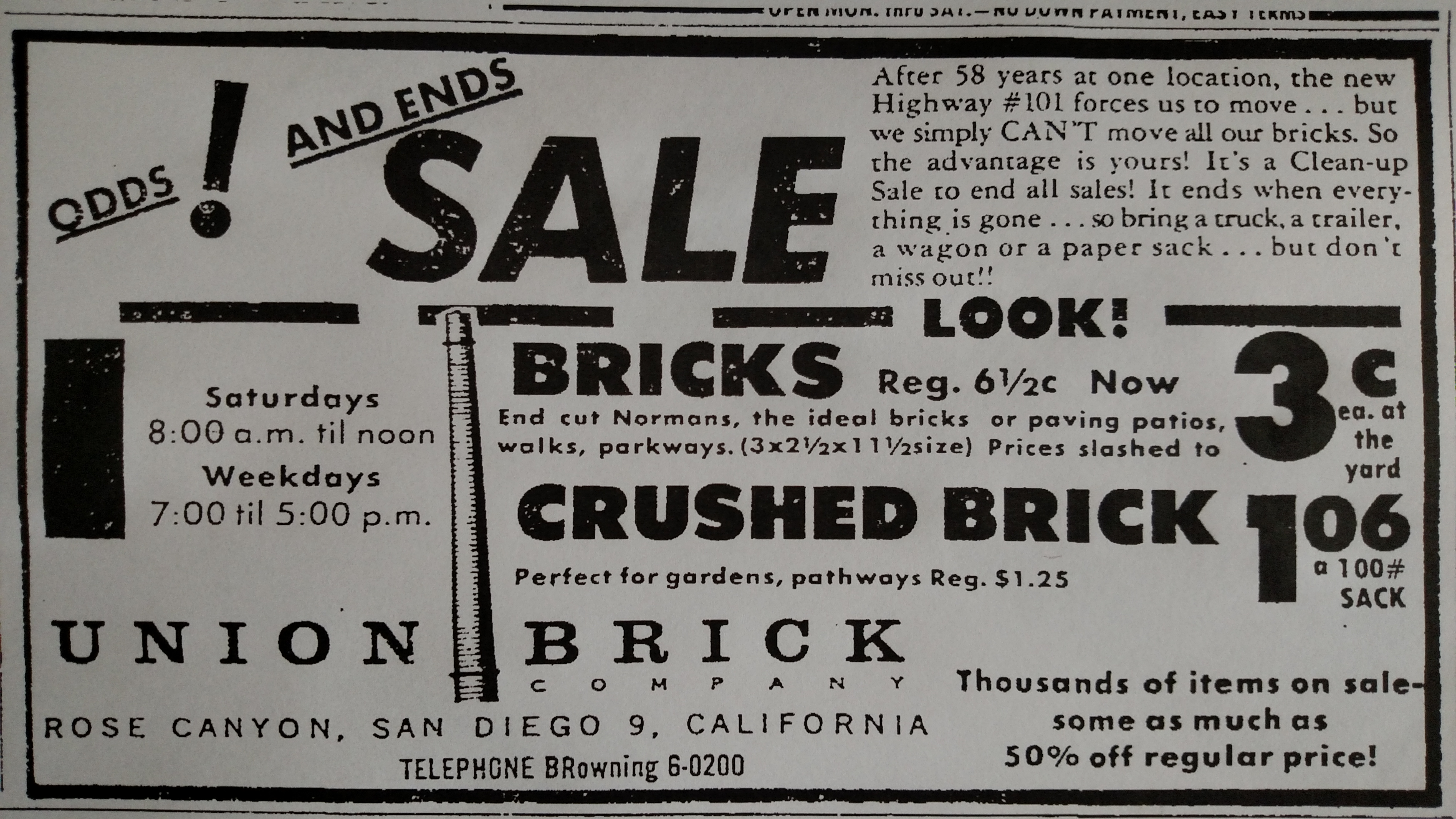


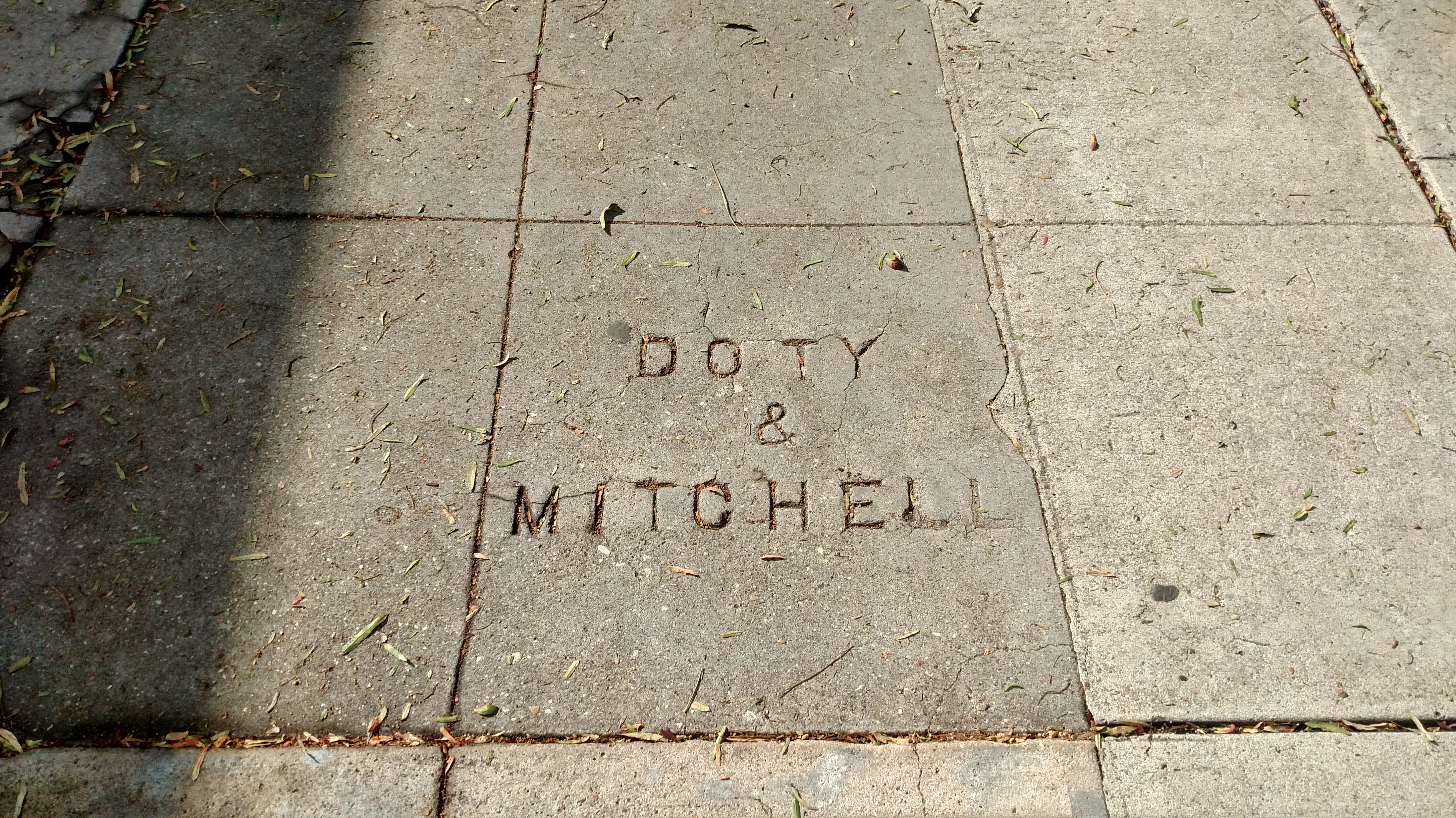
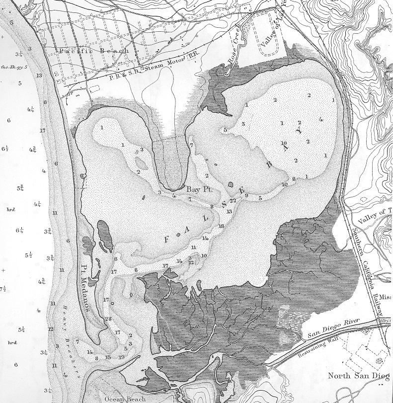

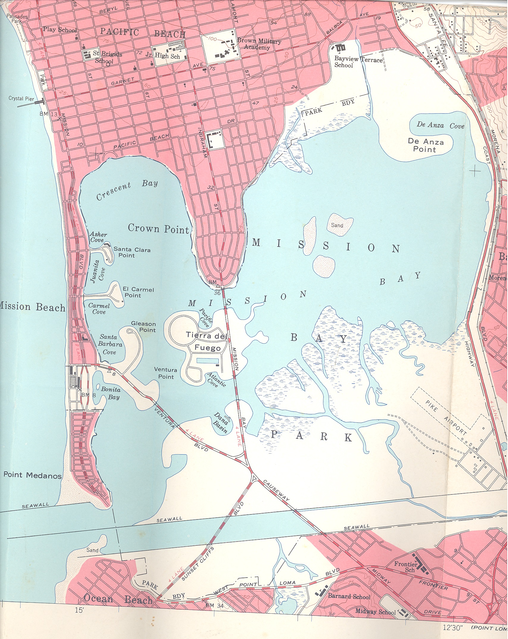


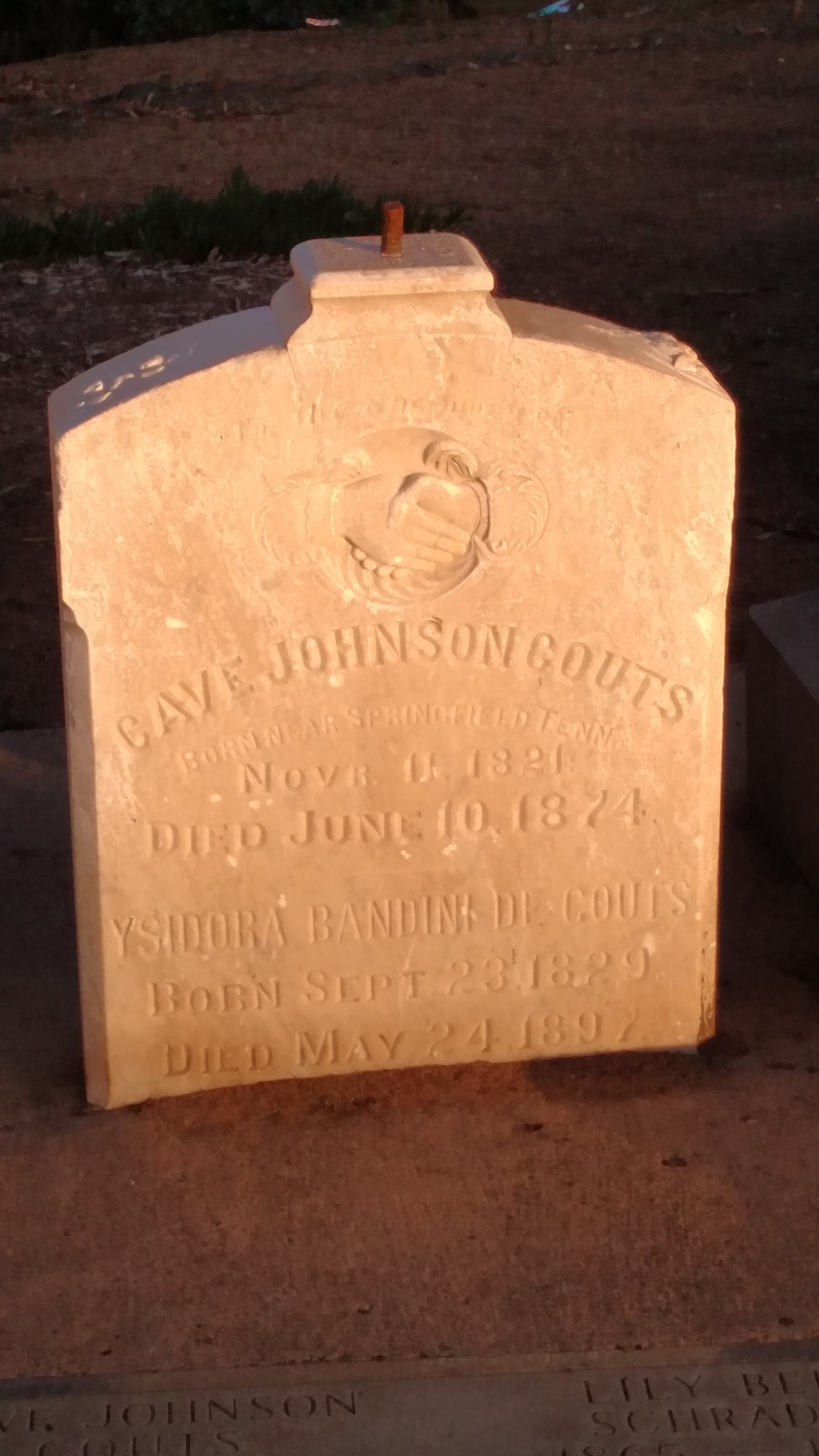


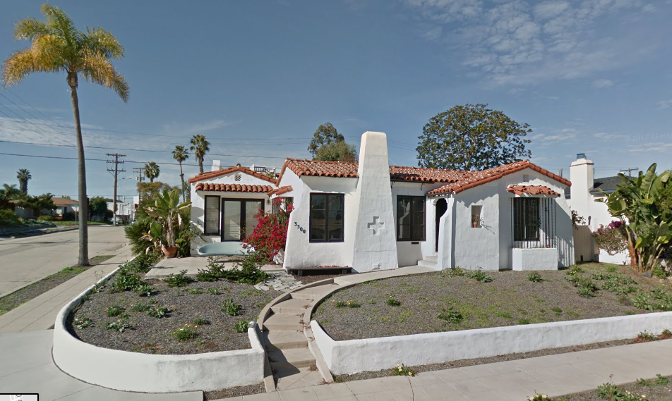
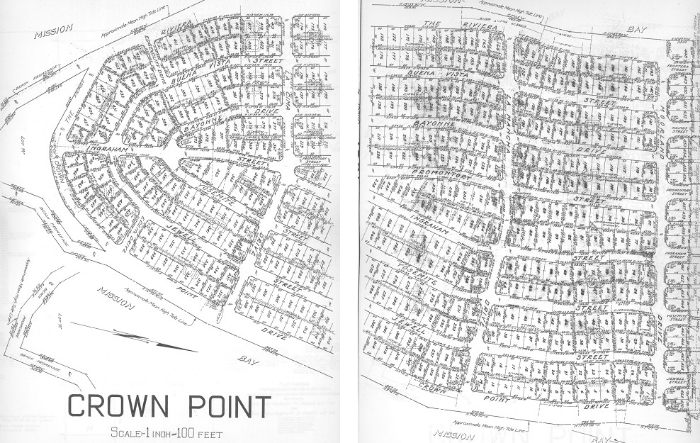


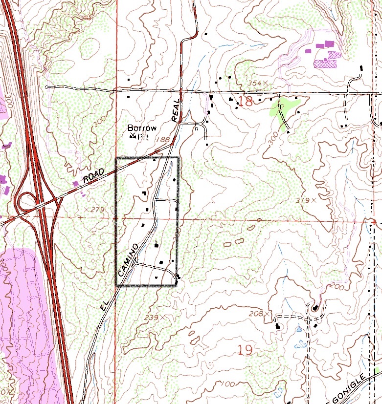